Mormon Row Historic District

Leaders of The Church of Jesus Christ of Latter-day Saints, or Mormons, sent parties from the Salt Lake Valley to establish new communities and support their expanding population. Mormon homesteaders, who settled east of Blacktail Butte near the turn of the 19-century, clustered their farms to share labor and community, a stark contrast with the isolation typical of many western homesteads. These settlers first arrived in the 1890s from Idaho establishing a community (named Grovont by the U.S. Post Office) known today as “Mormon Row.”
Homesteaders established 27 homesteads in the Grovont area because of relatively fertile soil, shelter from winds by Blacktail Butte and access to the Gros Ventre River. Despite the harsh conditions of Jackson Hole, Mormon settlers grew crops by using irrigation. These hardy settlers dug ditches by hand and with teams of horses, building an intricate network of levees and dikes to funnel water from central ditches to their fields between 1896 and 1937. Water still flows in some of these ditches.
Mormon Row Historic District was added to the National Register of Historic Places in 1997 as an Historic District.
Admission & Hours
Grand Teton National Park is open twenty-four hours every day, year-round. Seasonal road closures may limit auto access to some areas in the park during the winter.
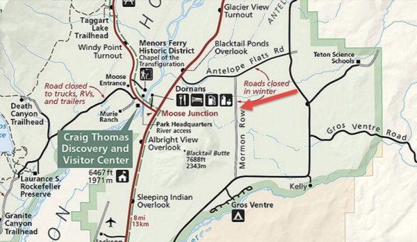
The roads to Mormon Row Historic District are closed from November 1st through April 30th.
The entrance fees are $30 for a private, noncommercial vehicle; $25 for a motorcycle; or $15 for each visitor 16 years and older entering by foot, bicycle, ski, etc. These fees provide the visitor with a 7-day entrance permit for Grand Teton National Park and the John D. Rockefeller, Jr. Memorial Parkway only. Yellowstone National Park has a separate entrance fee.
What to Photograph:
Moulton Barns
Today, two picturesque barns highlight Mormon Row. Settlers John and Thomas Alma (T.A.) Moulton built these barns on adjacent homesteads. After nearly 30 years of working the land, John replaced his log home and barn with a new carpenter-constructed, pink stucco frame house and impressive, two-story gambrel barn north of Antelope Flats Road. South of John’s homestead, T. A. took over 30 years to build his gable-with-shed style barn. Photographers from around the world stop by T. A. Moulton’s barn to capture this iconic historic structure with the Teton Range in the background.
Chambers Homestead
The most extensive historic complex remaining on Mormon Row is the Andy Chambers homestead. Andy Chambers claimed land in 1912 and secured the title under the Homestead Act by building a log cabin and stable and clearing ground to grow grain, a backbreaking chore in the rocky soil. The family lacked running water until 1927 and harnessed electricity with a windmill in 1946. The Rural Electric Administration did not provide power to Mormon Row until the 1950s. By this time, many families had sold their homesteads to become part of the park. The windmill still stands on the homestead.
Free roaming Bison can also be seen in the area.
Best Time for Photographers:
Probably the best time is early morning just as the sun comes up, it will be at your back and lighting the barns and the Tetons in the background. Good shots can be made throughout the day and the sun setting behind the Tetons can make some great shots. Another option is to photograph the night sky and light paint the barns at night.
Fall is a great time for color, there are a lot of Cottonwoods and Aspen which turn bright yellow. During the winter the road is closed and it can be very difficult to access, with hiking, snow showing, or cross country skiing being your only way in.
Getting There:
Driving Directions
Drive north from Jackson on highway 191 past Moose Junction and turn right onto Antelope Flats Road. Follow the road about 1 ½ miles until you see a north-south running dirt road marked by a distinctive pink stucco house on the left with a small dirt parking area. A trail brochure and interpretive sign can be found at the parking lot.
Maps:
Interactive Google Map
Use the map + – controls to zoom in and out, click and drag the to move the map, use the Map drop-down to change to “Map”, “Satellite”, “Hybrid”, or “Terrain” views. Drag the little man icon from the upper left corner to a map location for street level view.
Facilities
During the summer of 2015 plans are to add a trial along Mormon Row and a parking area with vault toilets.
Location Contact Information:
By Mail
Grand Teton National Park
P.O. Drawer 170
Moose, WY 83012-0170
By Phone
Information
(307) 739-3300
Information for the Hearing Impaired (TDD)
TDD is a telecommunications device for the deaf and requires an electronic device for text communication via a phone line at (307) 739-3400
By Email
E-Mail Us
Nearest City or Town:
Jackson Wyoming
Mormon Row Historic District Photo Gallery
Click Here for full page gallery
More Photographic Destinations in Wyoming:
Interactive Google Map
Use the map + – controls to zoom in and out, use the Map drop-down to change to “Map”, “Satellite”, “Hybrid”, or “Terrain” views. Drag the little man icon from the upper left corner to a map location for street level view. Click on a pushpin for more information about the Photographic Destination, then click on the title to go to the location page.
Click Here for Photographic Destinations by State


