Alabama Photographic Destinations


Kymulga Mill and Covered Bridge Sloss Furnaces National Historic Landmark Fort Morgan

Let me help you to find a great location in Alabama for your next photography adventure.  I will list many lesser known destinations, as well as the famous “Icon Locations” for photography.  I will provide photos (Lots of Photos), location information,  consisting of what there is to photograph as well as other information about the destination.  I will give costs, maps, directions, contact information, and other essential information for a successful photo trip.  I will only post for locations that I have personally photographed to insure a quality guide to great locations for photography in Alabama.


Interactive Google Map

Use the map  + – controls to zoom in and out, use the Map drop-down to change to “Map”, “Satellite”, “Hybrid”, or “Terrain” views.  Drag the little man icon from the upper left corner to a map location for street level view. Click on a pushpin for more information about the Photographic Destination, then click on the title to go to the location page.

Alabama Photographic Destinations

Alabama Destinations
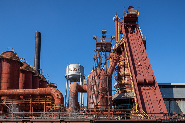
  Sloss Furnaces National Historic Landmark Sloss Furnaces was once the largest manufacturer of pig iron in the world. It stands today just as it did in the late 19th century — a monument to the Industrial Revolution. With its web of pipes and towering stoves, this unique National Historic Landmark provides visitors a glimpse into Birmingham’s rich industrial heritage.  Sloss Furnaces is a National Historic Landmark in Birmingham, Alabama in the United States. It operated as a pig iron-producing blast furnace from 1882 to 1971. After closing, it became one of the first industrial sites (and the only blast furnace) in the U.S. to be preserved and restored for public use. In 1981, the furnaces were designated a National Historic Landmark by the United States Department of the Interior. Erected in 1881-82 by noted southern industrialist James Withers Sloss, this is the oldest remaining blast furnace in the area and represents Alabama’s early 20th century preeminence in the production of pig iron and cast iron pipe. The complex, which remained in operation until 1970, is an outstanding symbol of the post-Civil War efforts to industrialize the South and of the intense economic competition that existed between the predominantly agrarian region and the already-industrialized North. The site currently serves as an interpretive museum of industry and hosts a nationally recognized metal arts program. It also serves as a concert and festival venue. A new visitor center was built 2015 and opened in 2016. The furnace site, along a wide strip of land reserved in Birmingham’s original city plan for railroads and industry, hosts thousands of students through their education programs per year. The museum is free to visit during their operating hours of Tuesday-Saturday 10:00 A.M to 4:00 P.M. and Sunday 12:00 to 4:00 P.M.   The Stock Tunnel Maps: Interactive Google Map Use the map  + – controls to zoom in and out, click and drag the to move the map, use the Map drop-down to change to “Map”, “Satellite”, “Hybrid”, or “Terrain” views.  Drag the little man icon from the upper left corner to a map location for street level view.   Location: 20 32nd Street NorthBirmingham, AL 35222 Get directions on Googles Maps GPS: 33°31’9.989″ N 86°47’37.187″ W Cost: Sloss Furnaces is free to enter during normal business hours. Photography Policy: Visitors to Sloss Furnaces National Historic Landmark who would like to take photographs of the site for personal use (to remember/document their trip, show to family and friends, hang in their homes) are encouraged to do so at NO CHARGE. While we still recommend visiting our Visitor’s Center, you do not need to fill out a Photography Policy application form. Sloss Furnaces defines amateur photographers as someone who uses professional equipment to take photographs, but does not receive any money or compensation for their product. Any amateur photographer who plans to exhibit their photographs to the public in any way MUST fill out the Photography Policy application form. We ask for a DONATION for using the site and to help fund our education programs. FEES‘STUDIO’ PHOTOGRAPHY:A. Amateur (unpaid) ‘studio’ photography: $20 for up to 3 hoursB. Professional (paid) ‘studio’ photography: See Professional Rates Below DRONE PHOTOGRAPHY:A. Drones taking still photographs: $25/hour $80/day PROFESSIONAL/COMMERCIAL SITE PHOTOGRAPHY (for advertisement, catalogues, or portfolios, social media): A. For Crews totaling 5 people, including models: $25/hour $75/dayB. For Crews more than 5 people, including models: $35/hour $125/dayC. For Crews more than 10 people, including models: $55/hour $250/dayD. For Crews more than 15 people, including model: $100/hour $500/dayE. Support vehicles, such as motor homes: $75/dayF. Additional fees may apply for extended hours, access to closed areas, or if permitted, any temporary modifications to the site. VIDEO/FILM WITHIN THE SITE FOR COMMERCIAL OR THEATRICALRELEASE: A. For Crews totaling 15 people, including actors: $50/hour $250/dayB. For Crews more than 15 people, including actors: $100/hour $500/dayC. For Crews more than 25 people, including actors: $200/hour $1,000/dayD. Support vehicles, including trailers: $100/dayE. Drone Video Footage: $50/hour $250/dayF. Additional fees may apply for extended hours, access to closed areas, or if permitted, any temporary modifications to the site. Hours: Closed Monday Tuesday – Saturday 10:00 A.M. to 4:00 P.M. Sunday 12:00 Noon to 4:00 P.M. Facilities:  A gift shop and restrooms are located in the visitor center. Location Contact Information: Sloss Furnaces National Historic Landmark 20 32nd Street North Birmingham, Alabama 35222 (205) 254-2025 GENERAL INFORMATION Regina Nash Administrative Clerk Regina.Nash@Birminghamal.gov (205) 254-2095 Links: Sloss Furnaces National Historic Landmark Sloss Furnaces Photo Gallery Click Here for full page gallery More Photographic Destinations in Alabama: Interactive Google Map Use the map  + – controls to zoom in and out, use the Map drop-down to change to “Map”, “Satellite”, “Hybrid”, or “Terrain” views.  Drag the little man icon from the upper left corner to a map location for street level view. Click on a pushpin for more information about the Photographic Destination, then click on the title to go to the location page. Click Here for Photographic Destinations by State    All the information in this post was believed to be accurate at the time it was published.  Please be sure to double check with the location before relying on this information as everything changes over time, especially hours, prices, and whether the location is still open.   Great Places for Great Photos   Let me help you to find a great location for your next photography adventure.  I will list many lesser-known destinations, as well as the famous "Icon Locations" for photography.  I will provide photos (Lots of Photos), location information, consisting of what there is to photograph as well as other information about the destination.  I will give costs, maps, directions, contact information, and other essential information for a successful photo trip.  I will only post for locations that I have personally photographed to ensure a quality guide to great locations for photography. If you know of great places that are not posted, please send me the details, I may just decide that is a place I need to go!     Greg Disch is a freelance photographer located in Arkansas. Greg specializes in nature, scenic, wildlife, and other outdoor subjects in Arkansas and other areas of the country.  Most of the images on this site are available for sale as prints, personal use, or rights managed stock photos. Greg offers both classroom instruction and in the field hands on photographic workshops. Classroom sessions are normally held in Fort Smith Arkansas, but arrangements can be made to bring a class to your group. All classes and workshops have small class sizes designed to provide an optimum student to instructor ratio, where you can get the personal attention, you need.  Most classes and workshops are limited to a maximum of six participants and will be held with a minimum of only two. If you are looking for a wonderful opportunity to get personal individual instruction, I do private workshops and classes at a location of your choice, whether doing a location photo shoot, coming to your home or business, traveling across the country on a road trip, or at my classroom.  This is a fantastic way to learn digital workflow and be sure that your computer equipment is properly configured for optimum performance. [...]Read more...
  Kymulga Mill and Covered Bridge Kymulga Mill is a working gristmill built in 1864 by German contractor G.E. Morris for Confederate Army Major George H. Forney, who was later promoted to lieutenant colonel. Forney died at the Battle of the Wilderness in Virginia before construction was completed, but his wife allowed Morris to finish it. Union Army soldiers burned most of the gristmills throughout the area during the Civil War, but Kymulga Mill was missed. The mill was sold four times before being purchased by the Childersburg Heritage Committee from latest owner Edward Donahoo in 1988, though it remained in active service through many of those years. Three water powered turbines ran the four-story mill, including lights, grain elevator and millstones used for grinding grain. Two of its five sets are French buhrs, thought to be the hardest rock in the world. Kymulga Mill continues to operate to this day, though under electricity, still making corn meal with its huge millstones. The building is now a tourist attraction open for guided tours. It also serves as a gift shop and park office.   The Kymulga Covered Bridge is a wood & metal combination style covered bridge that spans Talladega Creek, located just east of Kymulga Mill within Kymulga Park. Built in 1861, the 105-foot bridge is a Howe truss construction over a single span. The Kymulga Covered Bridge is one of two 19th-century covered bridges extant in Alabama still remaining at its original location; the Waldo Covered Bridge, also located in Talladega County, is the other. The bridge once provided access to the Old Georgia Road or the McIntosh Road, a Native American trade route which was used by settlers and frontiersmen who ventured the area. Eventually, farms and communities spawned along the former trail. The United States government purchased land adjacent to Kymulga Mill in 1941 for the Alabama Ordnance Works, a military installation. Settlements within the tract had to be relocated. Today, the Kymulga Covered Bridge leads park visitors to a series of nature trails north of Talladega Creek. People may still find remnants of the Old Georgia Road, as well as other traces of the past. Where it is: Located on Grist Mill Road four miles northeast of Childersburg, Alabama. 7346 Grist Mill Road Childersburg, AL 35044 Get Directions (256) 378-7436 Maps: Interactive Google Map Use the map  + – controls to zoom in and out, click and drag the to move the map, use the Map drop-down to change to “Map”, “Satellite”, “Hybrid”, or “Terrain” views.  Drag the little man icon from the upper left corner to a map location for street level view. GPS: Mill 33°20’2.1931″ N 86°17’59.102″ W Covered Bridge 33°20’3.738″ N 86°17’57.972″ W Cost: ENTRY FEE $3.00 Daily – per person – Children 5 and under free $20.00 Yearly – Individual membership / $30.00 Yearly – Family Membership Hours: Normal operating hours – Wednesday to Sunday, 9AM to 5PM.   Facilities: There are restrooms and camping facilities are available at the park as well as a pavilion rental. The part of the park near the bridge offers a venue for musical instruction and performances. Festivals, featuring folk music and dance, pioneer arts and crafts, storytelling and reenactments of local historical events could be held. Location Contact Information: 7346 Grist Mill Road Childersburg, AL 35044 Get Directions (256) 378-7436   Kymulga Mill & Covered Bridge Photo Gallery Click Here for full page gallery   More Photographic Destinations in Alabama Interactive Google Map Use the map  + – controls to zoom in and out, use the Map drop-down to change to “Map”, “Satellite”, “Hybrid”, or “Terrain” views.  Drag the little man icon from the upper left corner to a map location for street level view. Click on a pushpin for more information about the Photographic Destination, then click on the title to go to the location page. Click Here for Photographic Destinations by State    All the information in this post was believed to be accurate at the time it was published.  Please be sure to double check with the location before relying on this information as everything changes over time, especially hours, prices, and whether the location is still open.   Great Places for Great Photos   Let me help you to find a great location for your next photography adventure.  I will list many lesser-known destinations, as well as the famous "Icon Locations" for photography.  I will provide photos (Lots of Photos), location information, consisting of what there is to photograph as well as other information about the destination.  I will give costs, maps, directions, contact information, and other essential information for a successful photo trip.  I will only post for locations that I have personally photographed to ensure a quality guide to great locations for photography. If you know of great places that are not posted, please send me the details, I may just decide that is a place I need to go!     Greg Disch is a freelance photographer located in Arkansas. Greg specializes in nature, scenic, wildlife, and other outdoor subjects in Arkansas and other areas of the country.  Most of the images on this site are available for sale as prints, personal use, or rights managed stock photos. Greg offers both classroom instruction and in the field hands on photographic workshops. Classroom sessions are normally held in Fort Smith Arkansas, but arrangements can be made to bring a class to your group. All classes and workshops have small class sizes designed to provide an optimum student to instructor ratio, where you can get the personal attention, you need.  Most classes and workshops are limited to a maximum of six participants and will be held with a minimum of only two. If you are looking for a wonderful opportunity to get personal individual instruction, I do private workshops and classes at a location of your choice, whether doing a location photo shoot, coming to your home or business, traveling across the country on a road trip, or at my classroom.  This is a fantastic way to learn digital workflow and be sure that your computer equipment is properly configured for optimum performance. [...]Read more...
    Fort Morgan Fort Morgan is a historic masonry Pentagonal bastion fort at the mouth of Mobile Bay, Alabama, United States. Named for Revolutionary War hero Daniel Morgan, it was built on the site of the earlier Fort Bowyer, an earthen and stockade type fortification involved in the final land battles of the War of 1812. Skilled masons, many of which were enslaved African Americans, built the fortification which contains more than 46 million cubic yards of bricks. Construction was completed in 1834 and it received its first garrison in March of the same year.Used intermittently through the Spanish American War, World War I and World War II, the site showcases the evolution of seacoast fortifications and adaptations made by the U.S. Army for the defense of the country. In 1946 the site was turned over to the State of Alabama as a historic site. Fort Morgan was designated a National Historic Landmark in 1960. In 2007 it was listed as “one of the nation’s 10 most endangered battle sites” by the Civil War Preservation Trust in History Under Siege: A Guide to America’s Most Endangered Civil War Battlefields. In June 2008, a 90-pound live Union naval shell was uncovered at the site. The shell was from a Parrott rifle on a U.S. Navy warship and was fired at the fort in the summer of 1864. The discovery came during excavations as part of a project meant to repair cracks in the walls. Where it is: Fort Morgan is at the western end of Hwy 180, 22 miles west of Hwy 59 in Gulf Shores. You can reach the site from Dauphin Island by riding the Mobile Bay Ferry. Get directions on Google Maps Maps: Interactive Google Map Use the map  + – controls to zoom in and out, click and drag the to move the map, use the Map drop-down to change to “Map”, “Satellite”, “Hybrid”, or “Terrain” views.  Drag the little man icon from the upper left corner to a map location for street level view. Satellite View of Fort Morgan GPS: 30°13’43.35″ N 88°1’22.47″ W   Cost:  ADULT $7 * SENIOR OVER 65  $5 * STUDENT OVER 12 $5 * CHILD 6-12 $4 * UNDER 6 FREE Hours: GROUNDS, BEACH, AND FISHING — 8:00AM TO 5:00PM DAILY MUSEUM/GIFT SHOP 251-540-7127 — 9:00AM TO 4:30PM DAILY ADMINISTRATION OFFICE 251-540-5257– 8:00AM TO 5:00PM MON. thru FRI. CLOSED THANKSGIVING DAY, CHRISTMAS DAY, AND NEW YEARS DAY (GATES ARE LOCKED AT 5 PM) Facilities: Museum, restroom, seasonal snack bar. Location Contact Information: Site Director: Heather Tassin Museum: 251-540-5257 Email: heathertassin@fort-morgan.org Media Contact: Jacqulyn Kirkland, 334-230-2645, jacqulyn.kirkland@ahc.alabama.gov 51 Hwy 180 West, Gulf Shores, Alabama 36542   Fort Morgan Photo Gallery   Click Here for full page gallery More Photographic Destinations in Alabama: Interactive Google Map Use the map  + – controls to zoom in and out, use the Map drop-down to change to “Map”, “Satellite”, “Hybrid”, or “Terrain” views.  Drag the little man icon from the upper left corner to a map location for street level view. Click on a pushpin for more information about the Photographic Destination, then click on the title to go to the location page. Click Here for Photographic Destinations by State All the information in this post was believed to be accurate at the time it was published.  Please be sure to double check with the location before relying on this information as everything changes over time, especially hours, prices, and whether the location is still open.   Great Places for Great Photos   Let me help you to find a great location for your next photography adventure.  I will list many lesser-known destinations, as well as the famous "Icon Locations" for photography.  I will provide photos (Lots of Photos), location information, consisting of what there is to photograph as well as other information about the destination.  I will give costs, maps, directions, contact information, and other essential information for a successful photo trip.  I will only post for locations that I have personally photographed to ensure a quality guide to great locations for photography. If you know of great places that are not posted, please send me the details, I may just decide that is a place I need to go!     Greg Disch is a freelance photographer located in Arkansas. Greg specializes in nature, scenic, wildlife, and other outdoor subjects in Arkansas and other areas of the country.  Most of the images on this site are available for sale as prints, personal use, or rights managed stock photos. Greg offers both classroom instruction and in the field hands on photographic workshops. Classroom sessions are normally held in Fort Smith Arkansas, but arrangements can be made to bring a class to your group. All classes and workshops have small class sizes designed to provide an optimum student to instructor ratio, where you can get the personal attention, you need.  Most classes and workshops are limited to a maximum of six participants and will be held with a minimum of only two. If you are looking for a wonderful opportunity to get personal individual instruction, I do private workshops and classes at a location of your choice, whether doing a location photo shoot, coming to your home or business, traveling across the country on a road trip, or at my classroom.  This is a fantastic way to learn digital workflow and be sure that your computer equipment is properly configured for optimum performance. [...]Read more...