
Tallgrass Prairie Preserve

Tallgrass Prairie National Preserve was established on November 12, 1996 to preserve, protect, and interpret for the public an example of the tallgrass prairie ecosystem and the historic and cultural values represented by the Spring Hill Ranch. Once the bed of a vast inland sea located in the heart of the Flint Hills of Kansas, the preserve represents a portion of the less than 4% of remaining tallgrass prairie.
What to Photograph:
Spring Hill Ranch
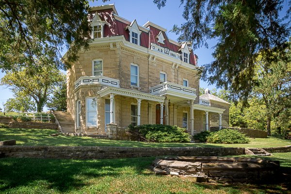
The grand four-level ranch house forms the centerpiece of the Spring Hill Farm and Stock Ranch. Completed in 1881, it stands as a beautiful example of French Second Empire architecture, a style popular in the late 19th century. This large, stately home is also an example of great change in the American West, the transition from small ranches on the vast open range to large enclosed ranching businesses, laying the foundations for the present-day American cattle industry.
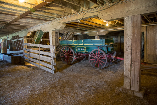
The Barn

Costing approximately $15,000 to construct, the large limestone barn is the focal point of the ranch’s cattle activities. The barn remains one of the largest historic limestone barns in Kansas, 60 feet wide by 110 feet long, containing approximately 19,000 square feet of floor space over three floors. The lower floor was set up as stables for cattle and horses. The main floor stored wagons and other equipment. The upper floor was used for hay and grain storage and was large enough to accommodate entire teams of horses and wagons. These wagons entered the upper floor by driving up one ramp and could exit by driving out either ramp.
The Prairie
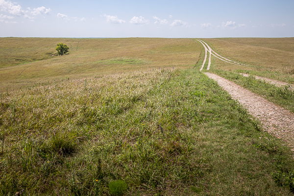
Tallgrass Prairie National Preserve was established on November 12, 1996 to preserve, protect, and interpret for the public an example of the tallgrass prairie ecosystem and the historic and cultural values represented by the Spring Hill Ranch. Once the bed of a vast inland sea located in the heart of the Flint Hills of Kansas, the preserve represents a portion of the less than 4% of remaining tallgrass prairie.
Fox Creek School
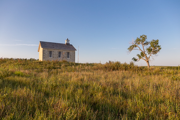
The Lower Fox Creek Schoolhouse was constructed in 1882 on land donated by Stephen Jones, with the stipulation that ownership would revert back to the ranch owner if it was no longer used as a school. Constructed by stone mason David Rettiger, who built the ranch house and the Chase County Courthouse, this one room school house with gable roof has coursed rubble limestone walls. The Schoolhouse was restored by a local group of garden clubs in the 1970s; the roof has been replaced and a chimney removed.
The Lower Fox Creek School is in the Tallgrass Prairie National Preserve. It can be accessed by driving there or by taking the Southwind Nature Trail. The school was used for 48 years until it was abandoned and handed over to the owner of the ranch. The schoolhouse is opened only on Saturday on Sunday in May, June, September and October from 12:00-4:00 p.m.
Best Time for Photographers:
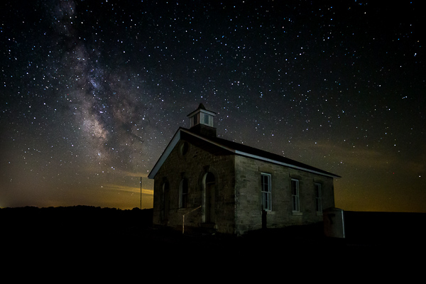
The area is accessible day or night and most anytime can make good photos. As with many subjects outdoors early morning or late evening with the sun low in the sky can give the beautiful golden hour warmth to your images.
Where it is:
The preserve is located in northern Chase County, Kansas 2 miles north of intersection U.S. Hwy 50 and Flint Hills National Scenic Byway 177 (K-177) west of Strong City. Watch for brown attraction signs.
The preserve is located:
- 2 miles north of Strong City, KS on K-177
- 16 miles west of Emporia, KS on U.S. Hwy 50 and 2 miles north on K-177
- 17 miles south of Council Grove, KS on K-177
- 85 miles northeast of Wichita on I-35, U.S. Hwy 50, and K-177
- 60 miles southwest of Topeka on I-335 (Kansas Turnpike) to Emporia, then 16 miles west on U.S. Hwy 50 and 2 miles north on K-177

Maps:
Interactive Google Map
Use the map + – controls to zoom in and out, click and drag the to move the map, use the Map drop-down to change to “Map”, “Satellite”, “Hybrid”, or “Terrain” views. Drag the little man icon from the upper left corner to a map location for street level view.
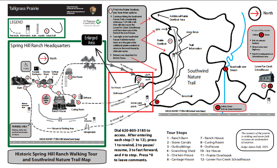
Grounds Map
Click map for a larger image
Trails Map
Click on map for a PDF version.

Cost:
There are no fees for the Tallgrass Prairie Preserve.
Hours:
Tallgrass Prairie National Preserve
Trails are open 24/7. Prescribed fire will close trails. Watch for signs. Visitor Center hours are 8:30 a.m. – 4:30 p.m. May through October. Visitor Center hours are 9:00 a.m. – 4:30 p.m. November through April
Standard Hours
- Sunday: –
- Monday: –
- Tuesday: –
- Wednesday: –
- Thursday: –
- Friday: –
- Saturday: –
Facilities:
Strong City and Cottonwood Falls Communities
Strong City is located two miles southeast of the historic ranch headquarters area on K-177 (Flint Hills National Scenic Byway). Restaurants, lodging, gasoline, postal services, and a city park are available.
Cottonwood Falls is the county seat and is located five miles southeast of the historic ranch headquarters area on K-177 (Flint Hills National Scenic Byway). Restaurants, lodging, gasoline, postal services, camping, two parks, library, museums, and area shops are available.
For a complete listing of all available goods and services in Chase County, visit the Chase County Chamber of Commerce website.
Links:
Tallgrass Prairie National Preserve
Location Contact Information:
2480B KS Hwy 177
Strong City, KS 66869
Phone:
(620) 273-8494 xhit 0
Tallgrass Prairie Photo Gallery
Click Here for full page gallery
More Photographic Destinations in Kansas:
Interactive Google Map
Use the map + – controls to zoom in and out, use the Map drop-down to change to “Map”, “Satellite”, “Hybrid”, or “Terrain” views. Drag the little man icon from the upper left corner to a map location for street level view. Click on a pushpin for more information about the Photographic Destination, then click on the title to go to the location page.
Click Here for Photographic Destinations by State