Chimney Rocks National Monument

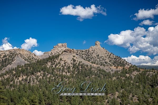
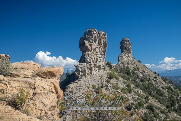
Chimney Rock lies on 4,726 acres of San Juan National Forest land surrounded by the Southern Ute Indian Reservation. Chimney Rock itself occupies 1,000 acres of the site, and is approximately 315 feet tall. Next to Chimney Rock is Companion Rock, which is a popular nesting spot for the Peregrine Falcon.
The site was once home to the ancestors of the modern Pueblo Indians, who built more than 200 homes and ceremonial buildings high above the valley floor more than 1,000 years ago. Archaeologists believe that the site marks a connection to the Chacoan society who inhabited Chaco Canyon in northwestern New Mexico.
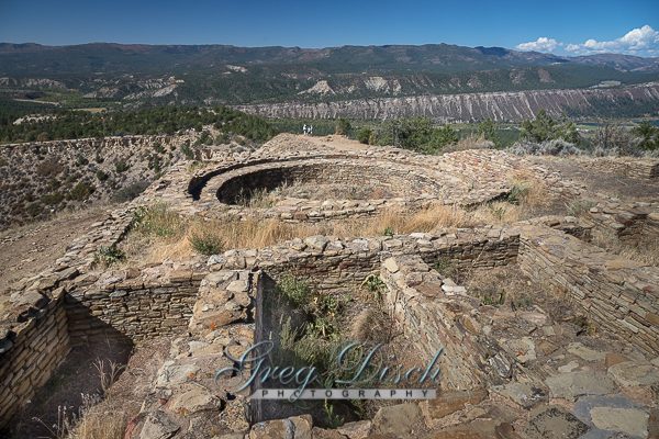
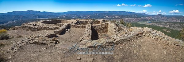
The area has 118 known archaeological sites, including the dramatic Great House Pueblo which likely was used as an observatory for the annual summer solstice. Other features include the Great Kiva, which was likely used for religious ceremonies and community activities; storage rooms; and residential pit houses.
History
The Ancestral Puebloan site, designated on the National Register of Historic Places in 1970, was a community inhabited between Durango and Pagosa Springs about 1,000 years ago with about 200 rooms. Rooms in the buildings were used for living, work areas and ceremonial purposes.
Housing approximately 2,000 ancient Pueblo Indians between AD 925 and 1125, the settlement included a Great House Pueblo with round ceremonial rooms, known as kivas, and 36 ground-floor rooms. A grizzly bear jaw found in one of the rooms when excavated suggested a reverence for the animal, and modern Chaco oral history suggests that the Bear clan originated in the Chimney Rock area.
The Chaco culture which inhabited the Chimney Rock area was hierarchical, with a priest class overseeing the area’s inhabitants. The construction of the Great House Pueblo at the top of the ridge, close to Chimney Rock and its neighbor Companion Rock, had a large ceremonial role in the later years of Chacoan presence. As the moon makes its lunar cycle across the sky over a period of 18.6 years, it appears in a lunar standstill between the two rocks for approximately 16 months.
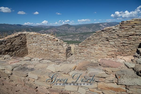
Evidence suggests that Great House Pueblo was first built in AD 1076 during a lunar standstill and expanded and finished in AD 1093 during another. It consists of 36 rooms and two kivas. Archaeologists believe that Great House Pueblo was mainly ceremonial in nature, with only one or two families living in its rooms. During certain key ceremonies, it functioned as a hotel for visiting notables, some of whom came from as far away as Chaco Canyon, in modern-day Northern New Mexico, 90 miles from Chimney Rock.
Material to build the Great House Pueblo came from downhill and was hauled by hand up the ridge line from further below. Five pithouses, titled Room A through E, probably housed the workers who built Great House Pueblo. Rooms A and B were excavated in 1921-1922 by early archaeologists, but their insufficient knowledge of how to stabilize walls, coupled with a decision to use the wood they found in the ruins for their campfires, has left little knowledge of these ruins, with little left today. The pottery was preserved and is now stored in boxes in the basement of the Anasazi Center in Durango.
Halfway between the worker’s houses and the Great House Pueblo was a ruin that archaeologists named the “Guardhouse.” It stretched from one side of the ridge to the other, and housed one family. Rather than serving as a defensive post against invaders, it more likely performed crowd control, keeping undesirables out of the Great House Pueblo, and letting the elites through. After excavation this ruin became extremely unstable and was eventually removed by the Forest Service for fear of visitors’ safety.
The base of the trail up to Great House Pueblo begins next to a pit-house complex made up of three pit houses and accompanying workrooms. An extended, multi generational family would have lived in this complex. Excavations of the workrooms showed separate areas with grinding stones for corn and a sort of “man cave” where men would make arrowheads and tools.
The last two excavated sites are a singular pit house and the Great Kiva. The Great Kiva shows similarities to others across the southwest, with a central fire pit, diverting stone and ventilation shaft.
It also has unique features. Instead of a bench that runs the perimeter to store ritual items, several pits in the ground were built, and they are believed to be storage areas. When excavated, archaeological students found a lack of wood and other roof materials; their hypothesis was that it had no roof and was open to the air. An alternative hypothesis is that it was never finished for a number of reasons. One is that—built in 1084—it was abandoned before they finished. The other is that during construction, the builders believed it had bad spirits and didn’t wish to finish.
The inhabitants of Chimney Rock abandoned the site in 1125, burning the buildings when they left. Their modern-day descendants consider the site sacred with the spirits of their ancestors, and have asked the Forest Service to refrain from further excavation out of respect.
Since the 1960s, Dr. Frank Eddy of the University of Colorado and others have studied the site, and research continues. 8 villages or settlements have been discovered in the area so far, a majority of which have remained unexcavated since Dr. Eddy’s work in the early 1970s.
Utilizing the provisions of the Antiquities Act, U.S. president Barack Obama elevated the archeological site to the status of a national monument on September 21, 2012.
What to Photograph:
Chimney Rock and Companion Rock, which are best photographed from farther away. The archaeological ruins including a Great Kiva, a Pit House, a Multi-Family Dwelling, and a Chacoan-style Great House Pueblo. From the top you have dramatic 360-degree views of Colorado and New Mexico.
The ancient structures are not easily accessible nor visible from any road. The guided walking tour includes four stabilized structures. The audio-guided tour visits two stabilized structures.
Best Time for Photographers:
Chimney Rock is a rarity within the USDA Forest Service. Recently designated a National Monument by the President, it remains under the domain of the Forest Service. As such, it is open to all visitors. However, there are seasonal closures and restrictions on entry into the Monument via motorized vehicle.
Access to the Visitor Cabin is by gravel road about one-half mile from the entrance gate. The gate is open from 9:00am to 4:30pm between May 15 and September 30. From October 1 through May 14, the entrance is locked but guests may hike on the Monument. During tour season, if you pay for a tour or event or have a special permit from the Forest Service, you may drive the 2 1/2 mile winding gravel road to the upper parking lot.
Visitors may hike into the Monument, ride horses, bicycle (only on the road) or snowshoe. If you decide to join a tour, you will be subject to the rules for that tour and asked to pay the fee.
Public access to the Pueblo Trail is seasonally restricted beyond the falcon closure fence (between March 1-September 30.) During this seasonal closure, only guided tours operated by the Chimney Rock Interpretive Association may use the trail, under authority of the USDA Forest Service special use permit.
Horses and dogs are not permitted on the interpretive trails.
Where it is:
DIRECTIONS:
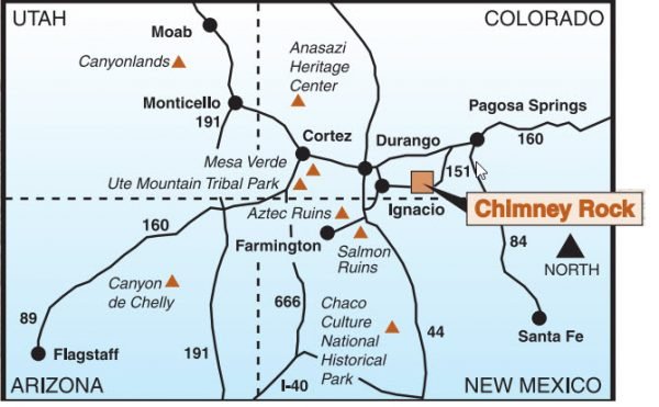
3 miles south of Hwy 160 on Hwy 151; 17 miles west of Pagosa Springs
Maps:
Interactive Google Map
Use the map + – controls to zoom in and out, click and drag the to move the map, use the Map drop-down to change to “Map”, “Satellite”, “Hybrid”, or “Terrain” views. Drag the little man icon from the upper left corner to a map location for street level view.
GPS:
37°11’29.868″ N 107°18’23.088″ W
Cost:
Tour Options
- 2-hour tour available at 9:30am & 1:00pm
- 1-hour tour available at 10:00am & 12:00pm
Trained volunteer interpretive guides will bring this beautiful site to life so you can visualize what it might have been like to live here 1,000 years ago? To fit your schedule, choose a 1-hour or 2-hour tour. The 2-hour tour provides access to the Pueblo Trail., the Kiva Trail and all four excavated structures. You’ll walk a little more than one mile and climb 200 feet. The 1-hour tour of the Pueblo Trail takes you to the Great House Pueblo below the pinnacles.
Kiva Audio-Guided Tour ($10/adult and $5/child (ages 5-12)
- Available between 10am – 3:00pm
Walk the Great Kiva Trail at your own pace; includes the excavated pit house and Great Kiva. This paved trail is one-half mile with little elevation change. There are two ways to enjoy an audio-guided tour:
- Purchase your audio-guided tour at the Visitor Cabin and receive a audio device with pre-recorded audio commentary that gives in-depth information about the structures viewed and the people who lived there.
- Download the San Juan National Forest app before you arrive at Chimney Rock, purchase your audio-guided tour at the Visitor cabin and receive a pin so you can use your own phone or device for the audio-tour.
Per federal regulations governing America the Beautiful passes, only the Senior and Access Passes are accepted at Chimney Rock, which entitle the pass holder to a 50% tour fee discount. The Senior Pass discount is extended to the spouse. (Non-transferrable). The America the Beautiful Annual Pass, which offers discounts for entrance fees at many sites nationwide, does not apply to “Expanded Amenities”, such as the interpretive tours offered here. Active Military personnel are provided a 15% discount on tour fees with proper I.D.
Hours:
May 15th-Sept. 30th
Gate Open: 9:00am-4:30pm
Last Tour at 3:00pm
Facilities:
There are restrooms and a visitor center with a gift shop at the site.
Location Contact Information:
P.O. Box 1662
Pagosa Springs, CO 81147
Monument: (970) 883-5359 (only May 15th-Sept. 30th)
Reservations: 877.444.6777
CRIA Office:(970)731-7133
Chimney Rock National Monument Photo Gallery
Click Here for full page gallery
More Photographic Destinations in Colorado:
Interactive Google Map
Use the map + – controls to zoom in and out, use the Map drop-down to change to “Map”, “Satellite”, “Hybrid”, or “Terrain” views. Drag the little man icon from the upper left corner to a map location for street level view. Click on a pushpin for more information about the Photographic Destination, then click on the title to go to the location page.
Click Here for Photographic Destinations by State
