Klepzig Mill

Walter Klepzig Mill and Farm is a historic farm and sawmill and national historic district located in the Ozark National Scenic Riverways near Eminence Missouri. The district encompasses three contributing buildings, three contributing sites, and one contributing structure associated with an early-20th century Ozark farm and mill. It developed between about 1912 and 1936 and includes the mill (c. 1912) and its related hydraulic system (c. 1912-1935); a spring house and smokehouse (c. 1920-1925); foundations of a 1923 farmhouse and barn (c. 1920-1925); and two post-1934 chicken coops and a ruin of a post-1934 machine shed.
It was listed on the National Register of Historic Places in 1990
Along Rocky Creek is a small turbine mill built by Walter Klepzig in 1928 –hence its name, Klepzig Mill. Walter, son of a Prussian German immigrant, was a progressive thinker. He was the first in the neighborhood to introduce both barbed and woven fence wire and a refined breed of milk cow. He sawed logs into boards for his house and out-buildings, and routinely saved “good boards” for use in building coffins for his neighbors. He frequently ground corn free for neighbors “on starvation,” i.e. those who could ill afford to leave him the customary toll of grain.
Klepzig Mill is a type of building referred to in the vernacular as a “sawmill house.” It was a building type that tended to replace log construction after the arrival of sawmills in a locale. A sawmill house could be erected quickly and by only one or two people. Instead of stud-wall framing, vertical planks were nailed to a hand-hewn sill at the bottom and a sawn two-by-four plate at the top. The resulting wall panels, fabricated flat on the ground, were then raised into place. Battens might then be added to cover the seams. Foundations were often piers of uncut and unmortared native stone.
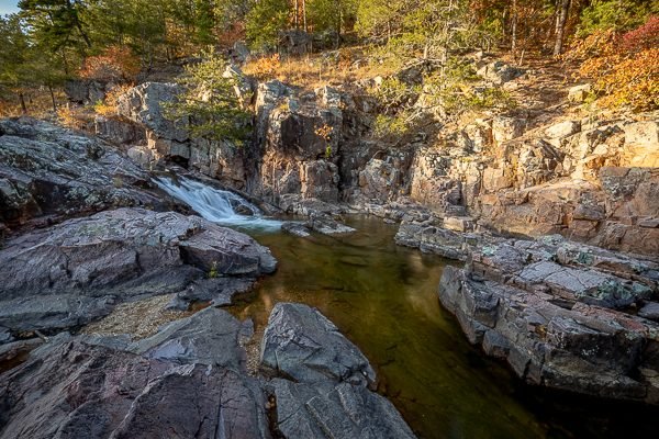
Klepzig Mill is not much to look at with its various accouterments and modifications– cement spillway, scrap metal hinge from the hood of a Model “A” Ford truck, old corrugated iron roof. Still, it is in a spectacular setting, surrounded by the rhyolite rock of the “shut in” canyon made by Rocky Creek. It is a lasting testament to the hardships of every day life in the Ozarks in a time not so long ago.
What to Photograph
The mill and outbuildings and Rocky Creek with some fantastic rock formations.
Where it is:
Klepzig Mill is located within the Ozark National Scenic Riverways which is the first national park area to protect a river system. The Current and Jacks Fork Rivers are two of the finest floating rivers you’ll find anywhere. Spring-fed, cold and clear they are a delight to canoe, swim, boat or fish. Besides these two famous rivers, the park is home to hundreds of freshwater springs, caves, trails and historic sites
To reach Klepzig Mill take Highway H (east of Eminence and Winona) to Highway NN. You’ll pass the sign for Rocky Falls, this is a pleasant stop also. Turn left on County Road #522. This dirt road can be very muddy and is narrow, not recommended for large motorhomes or trailers. Klepzig Mill is less than a mile on the right. There is no sign or defined parking area, and it’s easy to miss in summer vegetation, so watch carefully. It is also possible to hike to Klepzig Mill from Rocky Falls along the Ozark Trail, or park at the end of the pavement on NN and walk up the dirt road.
Maps:
Interactive Google Map
Use the map + – controls to zoom in and out, click and drag the to move the map, use the Map drop-down to change to “Map”, “Satellite”, “Hybrid”, or “Terrain” views. Drag the little man icon from the upper left corner to a map location for street level view.
GPS:
37°7’35.73″ N 91°11’52.926″ W
Cost:
Hours:
There are no hours, the location is accessible 24 hours a day.
Facilities:
There are no facilities at this location.
Location Contact Information:
Klepzig Mill Photo Gallery
Click Here for full page gallery
More Photographic Destinations in Missouri:
Interactive Google Map
Use the map + – controls to zoom in and out, use the Map drop-down to change to “Map”, “Satellite”, “Hybrid”, or “Terrain” views. Drag the little man icon from the upper left corner to a map location for street level view. Click on a pushpin for more information about the Photographic Destination, then click on the title to go to the location page.
Click Here for Photographic Destinations by State


