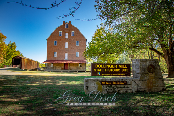
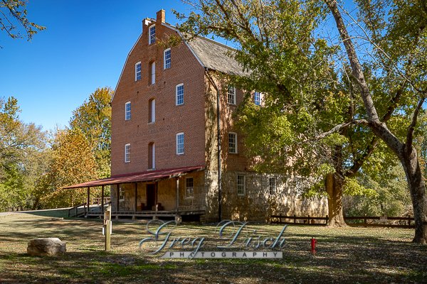
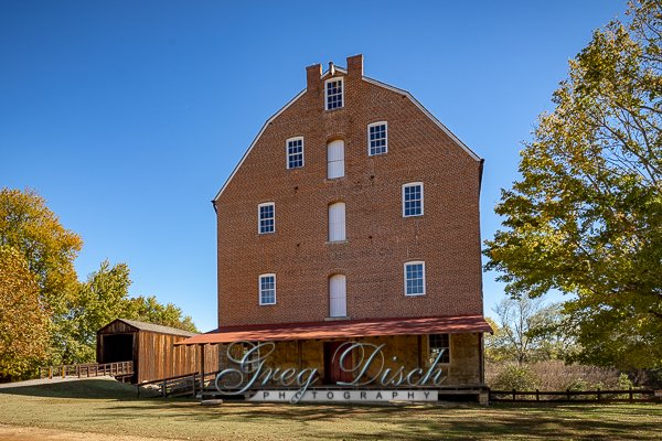
Bollinger Mill State Historic Site

After receiving a Spanish land grant, George Frederick Bollinger led a group of families from North Carolina to this area and in 1800 began construction of a mill and dam on the Whitewater River. The mill quickly became successful and by the 1820s, a road linked Bollinger Mill with surrounding communities. Bollinger himself became well known, entered politics, and served as a senator in Missouri’s first general assembly.
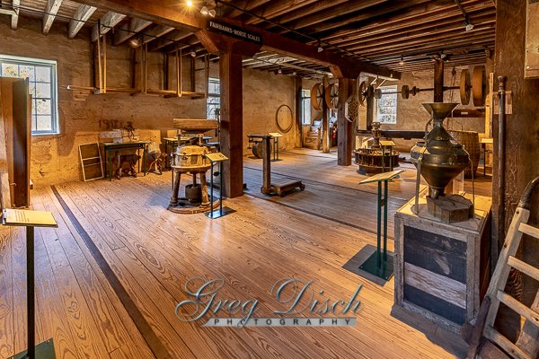
mill machinery inside the millThe mill and dam, originally constructed from logs, were rebuilt in stone in 1825 and this limestone foundation and dam are still visible today. When Bollinger died in 1842, his daughter, Sarah Daugherty, and her two sons continued to operate the popular mill.
During the Civil War, Union forces burned the mill to prevent the passing of flour and meal into rebel hands. Only the stone foundation survived.
After the war, the family sold the mill and 640 acres to Solomon R. Burford, who rebuilt the mill of brick upon the original stone foundation. The present-day, four-story stone and brick mill was completed in 1867 and Burford’s initials are still visible on the wall inside the front door. It was probably at this time that the method of powering the mill was changed from a water wheel to a more efficient, water-driven turbine.
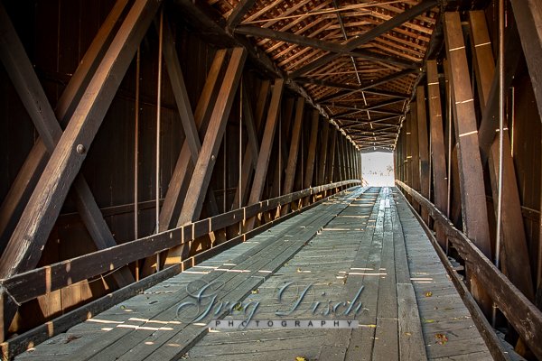
It was also at this time that the town of Burfordville came into existence. Construction of a covered bridge, begun before the war, was completed in 1868 and linked Burfordville to the main road. Made from nearby yellow poplar trees, the bridge was built by Joseph Lansmon, a well-known builder from Cape Girardeau. He used a Howe truss design, wherein diagonal wooden compression members are used with vertical iron rods in tension to form trusses. Historical records show that there was a toll house on the east end of the 140-foot-long bridge.
several vintage old cars parked in front of the millFrom 1897 to 1953, the mill was owned by the Cape County Milling Co. After the milling company went out of business in 1953, the mill was sold to the Vandivort family, relatives of George F. Bollinger. The Vandivorts, interested in seeing the mill preserved, donated it to the Cape Girardeau County Historical Society in 1961, who in turn donated it to the state in 1967. That same year, the Missouri legislature authorized the state park system to maintain all four of Missouri’s remaining covered bridges.
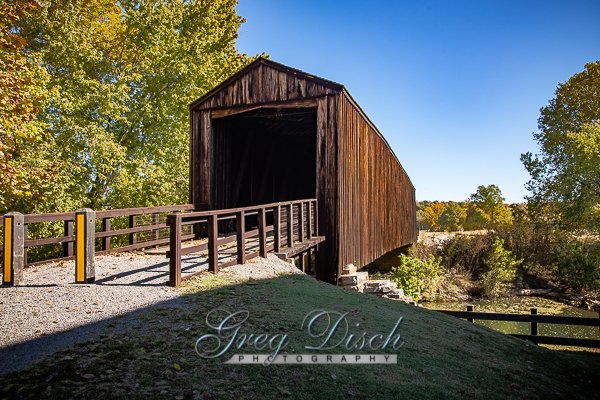
Burfordville Covered Bridge is the oldest remaining covered bridge in Missouri. Joseph Lansmon began its construction in 1858, but it is unclear if the bridge was completed before or after the Civil War. The bridge was not mentioned in St. Louis newspaper accounts of the 1861 burning of Bollinger Mill, located next to the bridge. After the Civil War, the bridge became a vital link, especially to farmers driving wagonloads of grain destined for the mill.
The bridge exhibits Howe-truss construction, named for William Howe, who patented the design in 1840. The essential feature of the design was its use of vertical iron rods to draw the diagonal wooden members tight against the top and bottom of the truss. The Howe-truss span was built mainly of yellow poplar. Burfordville Covered Bridge, which spans the Whitewater River, is 140 feet long and has a clearance 14 feet high and 12 feet wide.
The road going through the bridge was part of the toll-road system between Burfordville, Jackson and Cape Girardeau. At that time, toll roads and bridges were commonly operated as private businesses. Tolls were charged until 1906 when local farmers, tired of waiting for the courts to abolish the tolls, broke down the gates and used the roads without paying.
Although there were many advantages to the shelter provided by the roof and sides, the main purpose behind covering the bridges was to protect the intricate structural network of iron and timber trusses from the weather. The coverings also added strength, which reduced sagging and listing. Riders in uncovered buggies and carriages often used the bridges as shelters from wind, snow and rain.
What to Photograph
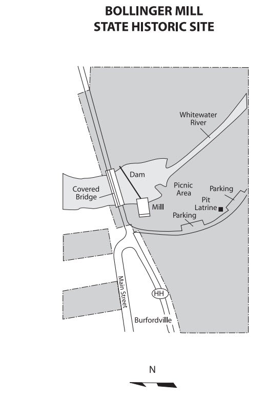
The historic mill, the dam on Whitewater River, and the Burfordville Covered Bridge.
Where it is:
Directions: From the intersection of US-61 and MO-34 (south of downtown) in Jackson take MO-34 west approximately 7 miles to County Road 360. Take a left and go south on County Road 360 approximately 2 mile to Bollinger Mill Road. Turn left on Bollinger Mill Road and proceed to the site.
Maps:
Interactive Google Map
Use the map + – controls to zoom in and out, click and drag the to move the map, use the Map drop-down to change to “Map”, “Satellite”, “Hybrid”, or “Terrain” views. Drag the little man icon from the upper left corner to a map location for street level view.
GPS:
37°22’5.867″ N 89°48’10.865″ W
Cost:
Hours:
PARK HOURS
Historic Site Grounds:
Sunrise to sunset, year-round (except New Year’s, Easter, Thanksgiving and Christmas days)
BOLLINGER MILL HOURS
Tours:
Tours are given on demand.
Summer Hours (On-Season)
March 15 through Nov. 15
10 a.m. – 4 p.m., Monday through Saturday (last tour begins at 3:30 p.m.)
Noon – 4 p.m., Sunday (last tour begins at 3:30 p.m.)
Winter Hours (Off-Season)
Nov. 16 through March 14
10 a.m. – 4 p.m. Monday and Thursday through Saturday (last tour begins at 3:30 p.m.)
Noon – 4 p.m. Sunday (last tour begins at 3:30 p.m.)
No tours are offered on Tuesday or Wednesday.
The historic site is closed New Year’s, Easter, Thanksgiving and Christmas days.
HISTORIC SITE OFFICE HOURS
8 a.m. to 4:30 p.m., Monday through Friday, year-round
Facilities:
Presently, there are two accessible picnic tables. Picnic sites are accessed over natural turf. The vault toilet is accessible via a concrete ramp and there is an accessible parking space. An accessible drinking fountain is along a concrete path near the parking space and vault toilet.
Location Contact Information:
Bollinger Mill Photo Gallery
Click Here for full page gallery
More Photographic Destinations in Missouri:
Interactive Google Map
Use the map + – controls to zoom in and out, use the Map drop-down to change to “Map”, “Satellite”, “Hybrid”, or “Terrain” views. Drag the little man icon from the upper left corner to a map location for street level view. Click on a pushpin for more information about the Photographic Destination, then click on the title to go to the location page.
Click Here for Photographic Destinations by State