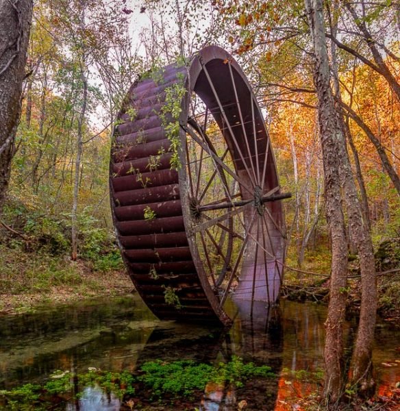
Turner’s Mill Wheel

Turners Mill is an extinct town in eastern Oregon County, in the state of Missouri. The mill was adjacent to Turners Spring on the north bank of the Eleven Point River. The community has the name of Jesse L. Clay Turner, the proprietor of a local mill. A variant name was “Surprise”. A post office called Surprise was established in 1895, and remained in operation until 1925.
Turner Spring is a lovely place for family fun. Turner Spring (1.5-million-gallon average daily flow), flows from a high rocky bluff and use to power a 25 ft metal mill. The Mill is in the Spring branch. There is no camping on the North side of the River. The North River Access is strictly for viewing and exploring.
What remains of Turner Mill is the huge overshot wheel, drive shafts and a stone burr, used fro grinding corn and wheat. Operated as early as the 1850’s by G.W. Decker, the original mill utilized a wooden overshot wheel. Jesse L. (Clay) Turner bought the mill in 1891. After partially rebuilding the wheel, he refurbished the four story mill building with a system of belts, pulleys and drive shafts, which operated a planer, drill press, various types of saws and the equipment for grinding wheat or corn. The Post Office was housed in one end of the mill.
The possession of enough power to operate the mill and the maintenance of the wheel were ongoing concerns. Turner abandoned the wooden wheel in favor of a turbine, which furnished power until 1915. The turbine was then replaced by a 25 foot steel overshot wheel hauled to the site in sections by oxen. Logs were brought to the mill by floating them down the Eleven Point River. Teams of Oxen hauled the logs out of the river. At that time roads were almost non-existent or very poor.
What to Photograph
The only thing remaining of Turner’s Mill is the 25′ Metal wheel that is still standing in the spring near where the mill was located many years ago.
Where it is:
The remains of the mill wheel are located at the Turner’s Mill Access point on the Eleven Point River in the Mark Twain National Forest 15 miles south of Winona, Missouri. Turner Mill North is located on the left side Eleven Point National Scenic River at mile 22.3. This access is 4.9 miles downriver of Greer Crossing. Located on the edge of the Irish Wilderness area near Alton, Missouri,
Directions: Turner Mill North Picnic Area is accessed by hilly, gravel Forest roads 3152 and 3190. The turnoff to Turner Mill is 15 miles south of Winona or 11 miles north of Alton on Hwy 19. From Hwy 19, turn onto FR 3152 for 6 miles then on FR 3190 for 3 miles.
when you reach the canoe access and picnic area there is a trail behind the vault toilets that follows the Turner Spring to the wheel.
Maps:
Interactive Google Map
Use the map + – controls to zoom in and out, click and drag the to move the map, use the Map drop-down to change to “Map”, “Satellite”, “Hybrid”, or “Terrain” views. Drag the little man icon from the upper left corner to a map location for street level view.
GPS:
36°45’59.746″ N 91°16’5.05″ W
Cost:
Hours:
There are no hours the site is open 24 hours a day.
Facilities:
There are vault toilets but no pother facilities at the mill site. The nearest town is Alton, MO.
Location Contact Information:
Turner’s Mill Photo Gallery
Click Here for full page gallery
More Photographic Destinations in Missouri:
Interactive Google Map
Use the map + – controls to zoom in and out, use the Map drop-down to change to “Map”, “Satellite”, “Hybrid”, or “Terrain” views. Drag the little man icon from the upper left corner to a map location for street level view. Click on a pushpin for more information about the Photographic Destination, then click on the title to go to the location page.
Click Here for Photographic Destinations by State


