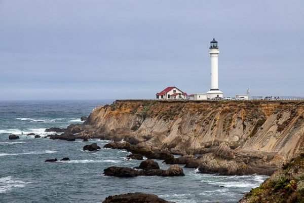
Point Arena Lighthouse

Point Arena Light is a lighthouse two miles north of Point Arena, California. The lighthouse features a small museum and giftshop. Guided tours of the light station as well as self-guided tours of the grounds are available daily.
The lighthouse at this site was constructed in 1870. The brick-and-mortar tower included ornate iron balcony supports and a large keeper residence with enough space to house several families. In April 1906, a devastating earthquake struck the light station. The keeper’s residence and lighthouse were damaged so severely they had to be demolished.
The United States Lighthouse Service contracted with a San Francisco based company to build a new lighthouse on the site, and specified that it had to be able to withstand any future earthquakes. The company chosen normally built factory smokestacks, which accounts for the final design for the new Point Arena Lighthouse, featuring steel reinforcement rods encased in concrete. This was the first lighthouse built this way.
The new lighthouse began operation in 1908, nearly 18 months after the quake. It stands 115 feet tall, and featured a 1st Order Fresnel Lens, over six feet in diameter and weighing more than six tons. The lens was made up of 666 hand-ground glass prisms all focused toward three sets of double bullseyes. It was these bullseyes that gave the Point Arena Lighthouse its unique “light signature” of two flashes every six seconds. The optics, which held an appraised value of over $3.5 million, was set in solid brass framework, and was built in France.
In 1984, a nonprofit organization called the Point Arena Lighthouse Keepers acquired the light station as part of a 25-year land lease from the Coast Guard and the Department of Transportation. In November 2000, the nonprofit group became the official owners of the property due to their diligent historic preservation and educational efforts. Daily visitation, gift store sales, memberships and the rental of the historic Keeper’s homes on the property as vacation houses, all provide income to the group, for ongoing preservation, facility upgrades, and educational endeavors.
What to Photograph
The lighthouse, the fog house and 23 acres of grounds surrounded on 3 sides by the Pacific Ocean.
Where it is:
To get there, follow Highway 1 north from the town of Point Arena and turn west onto Lighthouse Road at the sign for Lighthouse Pointe Resort. Follow this road to the end and follow signs for parking.
Maps:
Interactive Google Map
Use the map + – controls to zoom in and out, click and drag the to move the map, use the Map drop-down to change to “Map”, “Satellite”, “Hybrid”, or “Terrain” views. Drag the little man icon from the upper left corner to a map location for street level view.
GPS:
38°57’16.499″ N 123°44’26.615″ W
Hours:
Point Arena Lighthouse is open every day of the year except Thanksgiving Day and Christmas Day.
Hours of operation:
10 a.m. to 4:30 p.m. Memorial Day weekend through Labor Day
10 a.m. to 3:30 p.m. from the day after Labor Day to Memorial Day weekend
PLEASE NOTE: The last Tower Tour is at 3:15 p.m. (4:15 p.m. Memorial Day weekend through Labor Day). The grounds, Museum and Gift Store are open until 3:30 p.m. (4:30 p.m. Memorial Day weekend through Labor Day).
The Lighthouse will close early on Christmas Eve. Hours on December 24 will be from 10 a.m. to 1 p.m., with the last Tower Tour at 12:45 p.m.
Cost:
Museum admission, no Tower Tour: $5 per person (12 years and up), $1 for children ages 5 – 11, under 5 free
Museum & Tower Tour: $8 per person (12 years and up), $1 for children ages 5 – 11, under 5 free
Museum & Tower Tour per vehicle discount rate (5 to 8 people per vehicle): $35 per vehicle
Active Military & Veterans Admission including Tower tour: $6.50 per person
Location Contact Information:
Point Arena Lighthouse Photo Gallery
Click Here for full page gallery
More Photographic Destinations in California:
Interactive Google Map
Use the map + – controls to zoom in and out, use the Map drop-down to change to “Map”, “Satellite”, “Hybrid”, or “Terrain” views. Drag the little man icon from the upper left corner to a map location for street level view. Click on a pushpin for more information about the Photographic Destination, then click on the title to go to the location page.
Click Here for Photographic Destinations by State


