
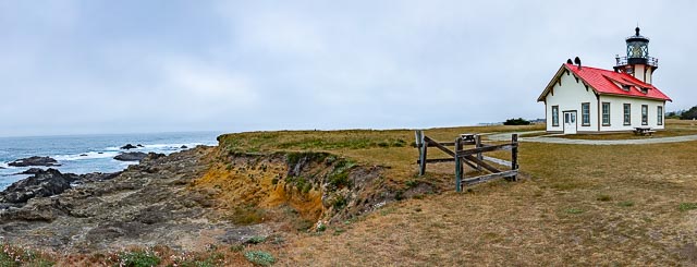
Point Cabrillo Lighthouse

Point Cabrillo Light is a lighthouse in northern California, United States, between Point Arena and Cape Mendocino, just south of the community of Caspar. It has been a federal aid to navigation since 1909. It is part of the California state valium no prescription park system as Point Cabrillo Light Station State Historic Park.
The Point Cabrillo Lighthouse complex is located about 1.5 miles north of Mendocino, California, and includes the lighthouse itself together with several outbuildings. Most of the original structures remain, but the barn is missing: in 1986 it was destroyed in a fire department exercise. The remaining lighthouse station is “one of the most complete light stations in the United States”

History:
Point Cabrillo, the sandstone headland on which the Point Cabrillo Light lies, was named in 1870 by the United States Geological Survey after the Portuguese explorer João Rodrigues Cabrilho, although Cabrillo’s voyage of exploration on behalf of Spain along the California coast did not reach as far north as the point. Because Spain controlled early California, the Spanish derivation of his name is the one used today. The opium-trading brig Frolic wrecked on a reef north of Point Cabrillo in 1850; the investigation of the wreck by agents of Henry Meiggs led to the discovery of the coast redwood forests of the Mendocino area and the beginning of the timber trade that would drive the local economy for decades.
In 1873, Point Cabrillo was surveyed as a potential site for a lighthouse; however, no lighthouse was built at that time. By 1904, several shipwrecks later, the U.S. Lighthouse Service recommended that a lighthouse be placed at the point. The bill to fund its construction, Senate Bill 6648, passed in June 1906, and the government bought 30 acres of land on Point Cabrillo from rancher David Gordon for $3,195. The lighthouse was constructed by the Lindgren Company beginning in 1908, and began operation in 1909. Its first light keeper was Wilhelm Baumgartner, who held the position until 1923. In 1935, an air diaphone supertyfone sound signal was installed.
The United States Coast Guard took over the Lighthouse Service in 1939. The lighthouse building sustained major damage in 1960 after a storm caused waves that crested above the light and flooded the building with mud, but the lens remained undamaged. Later during the Cold War, the station was used to simulate a Soviet radar base in training exercises. The Coast Guard manned the station until 1973, when the lens was covered and a modern rotating beacon was mounted on a metal stand on the roof west of the lantern room.
In 1988 the California Coastal Conservancy began buying the land surrounding the light station, and in 1991 the station was added to the National Register of Historic Places. However, the California State Park System declined to take over the land at that time because of state budget shortfalls; instead, the station was managed for nine years by a non-profit organization, the North Coast Interpretive Association. Beginning in 1996, the NCIA organized a major restoration of the station to the state it would have been in the 1930s, after it was electrified, including a return to active duty of the main lens of the light. In 1999, the original third-order Fresnel lens was reinstalled after being upgraded to meet more modern standards. Before it could be used the light had to be as reliable as a Directional Code Beacon, which is commonly used at airports. The restored lighthouse was opened to the public in August 2001, and appeared in the Warner Bros. 2001 drama film The Majestic. In 2002, California State Parks purchased the light station for four million dollars. The NCIA, which then became the Point Cabrillo Light Keeper Association, continued to run the station for the state park system. The station won the Governor’s Historic Preservation Award in 2007, and the Preservation Design Award of the California Preservation Foundation in the same year.
A hiking trail, part of the California Coastal Trail, was established in 2011 and connects the light station to Caspar Headlands State Beach one mile to the north, passing Frolic Cove along the way.
The Light Station includes:
- The Lighthouse, which is an active duty Aid to Navigation, containing the original Chance Brothers classic 3rd order Fresnel lens
- three restored Lightkeeper homes; the first house is a period museum of a lightkeeper’s house in the 1930s; the other two houses are comfortable vacation rental homes
- the restored Blacksmith & Carpentry Shop, which houses the Marine Science Exhibit with its 240 gallon saltwater aquarium
- three restored storage buildings behind the residences; two of these have been converted to lovely vacation rental cottages, the other is a public restroom
What to Photograph
The historic lighthouse and keepers quarters, which are one of the most intact light stations in the country.
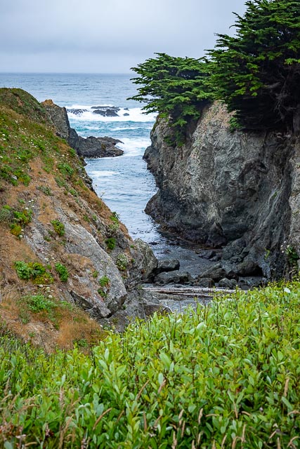
There are hiking trails throughout the Point which wind through coastal prairie and coastal bluff habitats.
Where it is:
Located on the Mendocino Coast, between Mendocino village and Fort Bragg, about halfway between Russian Gulch State Park and Caspar Beach, on Point Cabrillo Drive.
Parking: The Light Station is approximately one half mile walk from the entry gate on Point Cabrillo Drive. Please park vehicles in the paved parking area at the gate. The parking area is open from sunrise to sunset daily. Handicapped access parking is available at the Light Station in front of the residences.

Maps:
Interactive Google Map
Use the map + – controls to zoom in and out, click and drag the to move the map, use the Map drop-down to change to “Map”, “Satellite”, “Hybrid”, or “Terrain” views. Drag the little man icon from the upper left corner to a map location for street level view.
GPS:
39°20’55.948″ N 123°49’35.688″ W

Hours:

Cost:
There is not cost to visit the Point Cabrillo Light Station California State Historical Park, donations are welcome.
Drone Policy:
Due to the fragile and sensitive cultural and wildlife resources present at Point Cabrillo Light Station State Historic Park, the flying of private drones is prohibited throughout the Park.
Location Contact Information:
office phone: 707.937.6123
giftshop: send email to giftshop@pointcabrillo.org
general questions: send email to info@pointcabrillo.org
web site issues: send email to pclk.webmaster@jhfrey.com
Point Cabrillo Lighthouse Photo Gallery
Click Here for full page gallery
More Photographic Destinations in California:
Interactive Google Map
Use the map + – controls to zoom in and out, use the Map drop-down to change to “Map”, “Satellite”, “Hybrid”, or “Terrain” views. Drag the little man icon from the upper left corner to a map location for street level view. Click on a pushpin for more information about the Photographic Destination, then click on the title to go to the location page.
Click Here for Photographic Destinations by State