Talimena Scenic Drive

The Talimena National Scenic Byway, a breathtaking 54-mile route, is known for its spectacular views. Designated by the U.S. Department of Transportation as an official National Scenic Byway, Talimena Drive was built specifically to highlight the area’s beautiful foliage and spans one of the highest mountain ranges between the Appalachians and the Rockies.
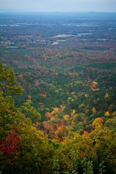
Join thousands of visitors during the fall season and view amazing fall foliage stretching as far as the eye can see. Awash in vibrant shades of red and gold, the forested slopes surrounding Talimena Drive make this scenic byway an autumn hot spot and regional crown jewel. Numerous viewpoints and scenic turnoffs along the Talimena Drive provide visitors with spectacular views of the fall color change. Stop at one of the 22 designated vistas along the route and take advantage of the route’s interpretive signage.
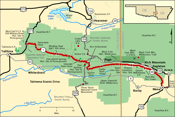
One of the first National forest Scenic Byways, the Talimena Scenic Drive, is located in the western part of the Ouachita Mountains. The drive, designated in February 1989, is between the city limits of Mena, Arkansas and a point of US highway 271 just north of Talihina, Oklahoma.
Constructed by the Oklahoma and Arkansas Highway departments between 1964 and 1969 with federal public highway funds, the route connected two truck trails originally built by Civilian Conservation Corps (CCC). The Oklahoma and Arkansas highway departments’ now maintain the byway.
Designated a National Scenic Byway by the America’s Byway Program in 2005, the road travels within the Ouachita National Forest along the highest peaks of the Winding Stair Mountains, part of the Ouachita Mountain chain, including the second tallest peak in Arkansas, Rich Mountain, 2,681 feet in elevation. Many of the forests along these ridges, stunted and of little commercial value, were never logged and are old growth. There are at least 13% hill grades along the route.
Queen Wilhemina State Park
Located atop Rich Mountain, Arkansas’s second highest peak, Queen Wilhelmina offers some of the most breathtaking views in the state from the fully renovated lodge. Travel the Talimena National Scenic Byway to this park and its lofty setting. This site is as rich in history as it is in scenery. The original lodge was built in the late 1800s as a Victorian resort named Wilhelmina Inn to honor the young Queen of the Netherlands. Two inns followed the original “Castle in the Sky.” The latest inn is today’s park lodge, the crowning attraction at Queen Wilhelmina State Park. The 40-room lodge features a new look and many modern updates. Enjoy Southern cuisine and first-class hospitality in the Queen’s Restaurant. A conference room with private balcony accommodates up to 75.
The park includes 41 campsites (eight Class A, 27 Class B, five tent sites with water, and one hike-in tent site), picnic areas, and trails. Interpretive programs highlight Rich Mountain’s fauna and unique flora and connect you to the fascinating history of the three inns that have graced this mountaintop site.

The lodge at Queen Wilhelmina State Park in Arkansas on the Talimena Scenic Drive in the Ouachita National Forest in Arkansas and Oklahoma.
What to Photograph
54 miles of vistas and scenic views on this National Scenic Byway.
Located on the Talimena Scenic Highway on the Ouachita National Forest, Rich Mountain Fire Tower is at the highest point on the road and is a popular picnic spot. The 42’ steel tower with a 14’x14’ Cl-100 metal cab was constructed in 1952 and used for fire detection until 1975. It replaced an unusual 6’x6’ wooden cab perched atop a 20’ log tower with a Spartan groundhouse living quarters.

An Ice storm hit the Talimena Scenic Drive in Decemer 2013, which runs from Mena AR to Talihina Ok. The road travels within the Ouachita National Forest along the highest peaks of the Winding Stair Mountains, part of the Ouachita Mountain chain.
Where it is:
Getting There:
FromtheWest (Oklahoma)
U.S. HIGHWAY 259
U.S. Highway 259 intersects the halfway point of the Talimena scenic Drive 5 miles north of Big Cedar, Oklahoma, and 18 miles south of Heavener, Oklahoma.
U.S. HIGHWAY 271
U.S. Highway 271 Intersect Oklahoma Highway 1. The Talimena Scenic Drive, at the West End Visitor Information Station, 7 miles northeast of Talihina, Oklahoma or 30 miles southwest of Poteau, Oklahoma.
FromtheEast (Arkansas)
ARKANSAS HIGHWAY 88
Arkansas Highway 88 intersects U.S. Highway 59/71 in the town of Mena.
The Talimena Scenic drive begins at the East End Visitor Information Station north of town.
ARKANSAS HIGHWAY 272
Arkansas Highway 272 intersects U.S. Highway 270/59 at the town of Rich Mountain, 8 miles North West of the town of Acorn, Arkansas. This highway goes directly to Queen Wilhelmina State Park.
GPS:
- The byway starts at the East End Visitor Information Station, GPS point (34.601078,-94.243223).
- Drive north on State Hwy. 88/Talimena Scenic Dr. to the state line of Arkansas and Oklahoma. GPS point (34.693553,-94.455697)
Maps:
Interactive Google Map
Use the map + – controls to zoom in and out, click and drag the to move the map, use the Map drop-down to change to “Map”, “Satellite”, “Hybrid”, or “Terrain” views. Drag the little man icon from the upper left corner to a map location for street level view.
Hours:
There is no cost to drive the Talimena Scenic Drive.
Facilities:
Location Contact Information:
Talimena Scenic Drive Photo Gallery
Click Here for full page gallery
More Photographic Destinations in Arkansas:
Interactive Google Map
Use the map + – controls to zoom in and out, use the Map drop-down to change to “Map”, “Satellite”, “Hybrid”, or “Terrain” views. Drag the little man icon from the upper left corner to a map location for street level view. Click on a pushpin for more information about the Photographic Destination, then click on the title to go to the location page.


Hi there I grew up in talihinia Oklahoma my uncle used to be forest ranger at the talimena drive is it such a beautiful drive thank you for sharing this item have a great day