Ruby Ghost Town

Ruby is a ghost town in Arizona, founded as a mining town in Bear Valley, originally named Montana Camp, so named because the miners were mining at the foot of Montana Peak.
Mining started circa 1877. The Montana Mine produced gold, silver, lead, zinc and copper. At its peak in the mid-1930s, Ruby had a population of about 1,200.
On April 11, 1912 the mining camp’s general store owner Julius Andrews established the post office. Andrews named the post office “Ruby”, after his wife, Lille B. Ruby Andrews, and the mining camp soon became known as Ruby. The post office was discontinued on May 31, 1941.
Between 1920 and 1922, the town of Ruby and the surroundings were the scene of three double homicides known as the Ruby Murders, which led to the largest manhunt in the history of the Southwest.
The most prosperous period for Ruby was in the late 1920s and 1930s, when the Eagle-Picher Mining Company operated the mine and upgraded the camp. From 1934 to 1937, the Montana mine was the leading lead and zinc producer in Arizona. In 1936, it was third in silver production. The mine closed in 1940, and by the end of 1941 Ruby was abandoned.
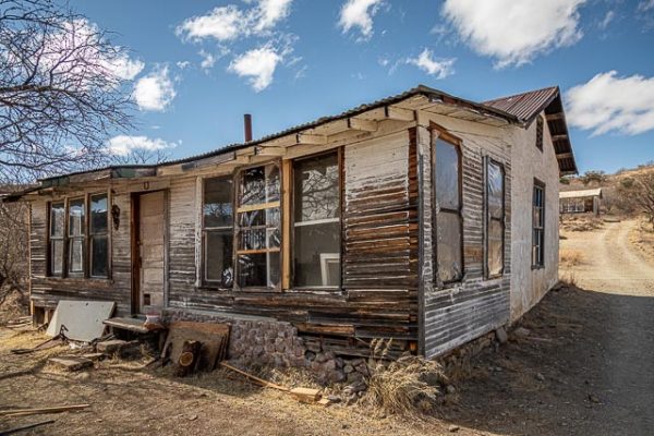
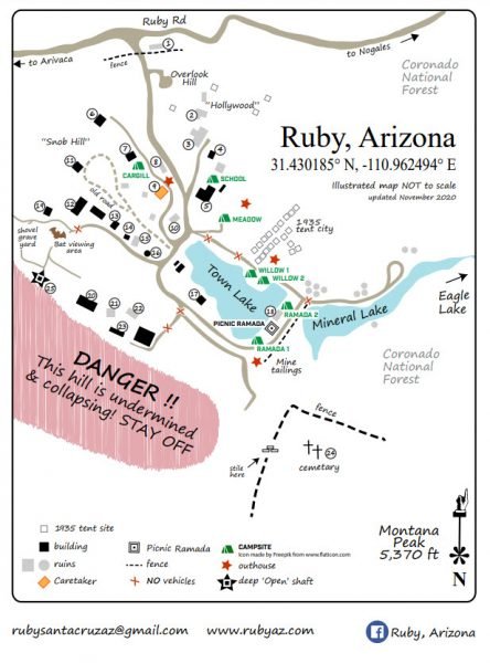
Ruby is one of the two best-preserved mining ghost towns in Arizona, along with the Vulture Mine near Wickenburg. Ruby’s attractions today include approximately 25 buildings under roof, including the jail and houses, the school, the playground, mine machinery, buildings and mine workings.
Ruby is entirely on private property and there is a charge for admission to the site.
Where it is:
Ruby is about 70 miles south of Tucson Arizona. There will about 6 miles on a rough dirt road which is normally drivable with a normal car.
FROM TUCSON
Take I-19 south to exit 48 (Amado)
Follow Arivaca Rd. (paved) 22 miles west to Arivaca
Once in Arivaca, follow the sign to Ruby (south)
Go past Arivaca Lake and continue on paved road to Santa Cruz County line
Continue on the dirt road 6 miles to the Ruby access road.
FROM NOGALES
Take Ruby Road (SR289) past Pena Blanca Lake
From Pena Blanca Lake, take Forest Service Road 39 (Ruby Road) to Ruby
Maps:
Interactive Google Map
Use the map + – controls to zoom in and out, click and drag the to move the map, use the Map drop-down to change to “Map”, “Satellite”, “Hybrid”, or “Terrain” views. Drag the little man icon from the upper left corner to a map location for street level view.
GPS:
31°27’52.836″ N 111°14’19.092″ W
Cost:
Hours:
The gates are open from 9am-dusk Thursday through Sunday for self-guided tours. You may have to walk in and get a permit and code to open the gate.
Reservations can be made online for other times by requesting a Visit Permit.
Check their Facebook page to be sure they are open.
Ruby Ghost Town Photo Gallery
Click Here for full page gallery
More Photographic Destinations in Arizona
Interactive Google Map
Use the map + – controls to zoom in and out, use the Map drop-down to change to “Map”, “Satellite”, “Hybrid”, or “Terrain” views. Drag the little man icon from the upper left corner to a map location for street level view. Click on a pushpin for more information about the Photographic Destination, then click on the title to go to the location page.
Click Here for Photographic Destinations by State


