Mount Rushmore National Memorial

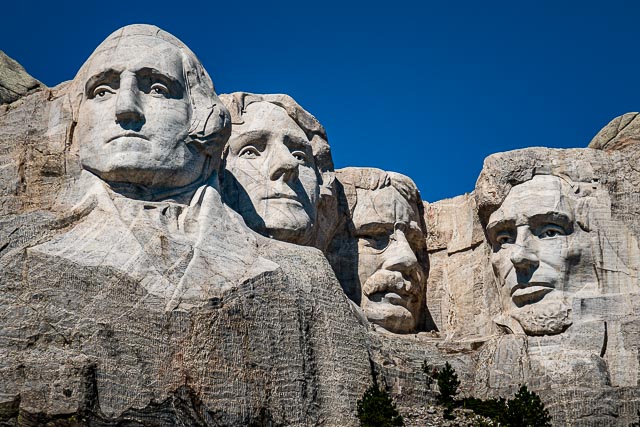
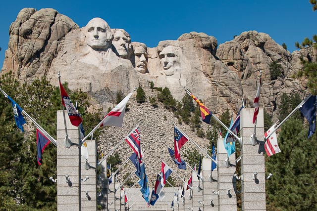
Mount Rushmore National Memorial is centered on a colossal sculpture carved into the granite face of Mount Rushmore in the Black Hills in Keystone, South Dakota. Sculptor Gutzon Borglum created the sculpture’s design and oversaw the project’s execution from 1927 to 1941 with the help of his son, Lincoln Borglum. The sculpture features the 60-foot heads of Presidents George Washington (1732–1799), Thomas Jefferson (1743–1826), Theodore Roosevelt (1858–1919) and Abraham Lincoln (1809–1865). The four presidents were chosen to represent the nation’s birth, growth, development and preservation, respectively.
South Dakota historian Doane Robinson is credited with conceiving the idea of carving the likenesses of noted figures into the mountains of the Black Hills of South Dakota in order to promote tourism in the region. His initial idea was to sculpt the Needles; however, Gutzon Borglum rejected the Needles because of the poor quality of the granite and strong opposition from the Lakota (Sioux), who consider the Black Hills to be sacred ground; it was originally included in the Great Sioux Reservation. The United States broke up the territory after gold was discovered in the Black Hills. The mountain into which it was carved is known to the Lakota Sioux as Six Grandfathers.
The sculptor and tribal representatives settled on Mount Rushmore, which also has the advantage of facing southeast for maximum sun exposure. Robinson wanted it to feature American West heroes, such as Lewis and Clark, their expedition guide Sacagawea, Oglala Lakota chief Red Cloud, Buffalo Bill Cody, and Oglala Lakota chief Crazy Horse. Borglum believed that the sculpture should have broader appeal and chose the four presidents.
Peter Norbeck, U.S. Senator from South Dakota, sponsored the project and secured federal funding. Construction began in 1927; the presidents’ faces were completed between 1934 and 1939. After Gutzon Borglum died in March 1941, his son Lincoln took over as leader of the construction project. Each president was originally to be depicted from head to waist, but lack of funding forced construction to end on October 31, 1941.
Sometimes referred to as the “Shrine of Democracy”, Mount Rushmore attracts more than two million visitors annually.
Where it is:
Visitors traveling by car on I-90 should exit at Rapid City and follow U.S.. Highway 16 southwest to Keystone and then South Dakota Highway 244 to Mount Rushmore. Visitors coming from the south should follow U. S. Highway 385 north to South Dakota Highway 244, which is the road leading to the memorial.
Maps:
Interactive Google Map
Use the map + – controls to zoom in and out, click and drag the to move the map, use the Map drop-down to change to “Map”, “Satellite”, “Hybrid”, or “Terrain” views. Drag the little man icon from the upper left corner to a map location for street level view.
GPS:
Latitude/Longitude Coordinates for Mount Rushmore National Memorial
| N 43° 53.559′ | W 103° 28.246′ |
Decimal coordinates
| 43.8789472 | -103.459825 |
Universal Transverse Mercator (UTM) for Mount Rushmore National Memorial
| 623773E 4859716N Zone 13 |
Cost:
Parking Fees
| Cars, Motorcycles and RVs | $10 per vehicle $5 for Seniors (62 and older) Free for Active Duty Military |
| Commercial Tour Bus | $50* |
| Verified, nonprofit Educational Bus | $25* |
Hours:
Parking Structure and Memorial Grounds Hours
|
Mount Rushmore National Memorial Photo Gallery
Click Here for full page gallery
More Photographic Destinations in South Dakota
Interactive Google Map
Use the map + – controls to zoom in and out, use the Map drop-down to change to “Map”, “Satellite”, “Hybrid”, or “Terrain” views. Drag the little man icon from the upper left corner to a map location for street level view. Click on a pushpin for more information about the Photographic Destination, then click on the title to go to the location page.
Click Here for Photographic Destinations by State


