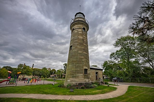
Pennsylvania Photographic Destinations

Hopewell Furnace National Historic Site Presque Isle Lighthouse Erie Land Lighthouse Knox Covered Bridge

Let me help you to find a great location in Pennsylvania for your next photography adventure.  I will list many lesser known destinations, as well as the famous “Icon Locations” for photography.  I will provide photos (Lots of Photos), location information,  consisting of what there is to photograph as well as other information about the destination.  I will give costs, maps, directions, contact information, and other essential information for a successful photo trip.  I will only post for locations that I have personally photographed to insure a quality  guide to great locations for photography in Arkansas.

Interactive Google Map

Use the map  + – controls to zoom in and out, use the Map drop-down to change to “Map”, “Satellite”, “Hybrid”, or “Terrain” views.  Drag the little man icon from the upper left corner to a map location for street level view. Click on a pushpin for more information about the Photographic Destination, then click on the title to go to the location page.


Pennsylvania Photographic Destinations

Pennsylvania Destinations
Presque Isle Lighthouse The Presque Isle Light, historically nicknamed the “Flash Light”, is a lighthouse on the shore of Lake Erie in U.S. state of Pennsylvania. It is one of three lighthouses in Erie, along with the Erie Land Light and the North Pier Light. The lighthouse is situated on the northern shoreline of Presque Isle State Park overlooking the beach. The lighthouse became active on July 12, 1873 and was listed on the National Register of Historic Places in 1983. The Presque Isle Light is 68 feet tall with a focal height of 63 feet. Originally, the tower was only 40 feet tall before it was raised to its current height. It has a light characteristic consisting of a 6-second, white isophase light (3 seconds on, 3 seconds off) that is visible up to 15 nautical miles from the lighthouse. Up until August 2013, a backup, emergency light was mounted below the main beacon that would flash every 10 seconds at a “reduced intensity” if the main beacon was non-operational. Around the same time as the removal of the emergency light, the main beacon was replaced with a six-tier, light-emitting diode, Vega marine beacon. The lighthouse tower is attached a four-bedroom residence used by the lighthouse keeper. The whale oil and, eventually, kerosene necessary to keep the lighthouse illuminated for the entire night was stored in the room at the base of the stairs leading to the lantern room. For safety reasons, the rest of the fuel was stored in a shed located elsewhere on the property. After it was electrified, the oil room became the storage room for the batteries powering the light. On July 25, 2014, the Department of Conservation and Natural Resources transferred the Presque Isle Light, in a 35-year lease to a nonprofit organization charged with restoring and operating the lighthouse as a museum. The lighthouse was reopened to the public for tours in the summer of 2015. Renovations will see the 1989-additions, as well as most of the modern amenities, removed to return the lighthouse to its appearance in the late-1800s and early-1900s. Where it is: The Presque Isle Lighthouse is located in the Presque Isle State Park in Erie Pennsylvania. From the intersection of Interstates 79 and 90 near Erie, go north on Interstate 79 5.6 miles to its end at 12th Street. Turn left on 12th Street, travel 1.1 miles, and turn right on Peninsula Drive (Highway 832). Follow Peninsula Drive 5.6 miles onto Presque Isle Peninsula and into Presque Isle State Park where you will see the lighthouse on your left. Links: Presque Isle Lighthouse GPS: 42°9’57.378″ N 80°6’55.734″ W Hours: Presque Isle is a day-use park that provides year-round recreational opportunities. Open for the season Open daily: 10 am to 5 pm from mid-April through August, and Friday through Sunday from 10 a.m. to 4 p.m. in September and October. Online Shop open 24/7 Grounds open during operational hours only. Cost: Presque Isle Lighthouse Tower Climb $8, Free for members Includes self-guided access to house and grounds Available every 20-minutes, no reservation required Must be 44″ tall to climb Location Contact Information: Mailing Address Presque Isle Lighthouse 301 Peninsula Drive Erie, PA 16505 (814) 833-3604 Email Presque Isle State Park 301 Peninsula Drive, Suite 1 Erie, PA 16505-2042 814-833-7424 presqueislesp@pa.gov Presque Isle Lighthouse Photo Gallery Click Here for full page gallery     More Photographic Destinations in Pennsylvania Interactive Google Map Use the map  + – controls to zoom in and out, use the Map drop-down to change to “Map”, “Satellite”, “Hybrid”, or “Terrain” views.  Drag the little man icon from the upper left corner to a map location for street level view. Click on a pushpin for more information about the Photographic Destination, then click on the title to go to the location page. Click Here for Photographic Destinations by State All the information in this post was believed to be accurate at the time it was published.  Please be sure to double check with the location before relying on this information as everything changes over time, especially hours, prices, and whether the location is still open.   Great Places for Great Photos   Let me help you to find a great location for your next photography adventure.  I will list many lesser-known destinations, as well as the famous "Icon Locations" for photography.  I will provide photos (Lots of Photos), location information, consisting of what there is to photograph as well as other information about the destination.  I will give costs, maps, directions, contact information, and other essential information for a successful photo trip.  I will only post for locations that I have personally photographed to ensure a quality guide to great locations for photography. If you know of great places that are not posted, please send me the details, I may just decide that is a place I need to go!     Greg Disch is a freelance photographer located in Arkansas. Greg specializes in nature, scenic, wildlife, and other outdoor subjects in Arkansas and other areas of the country.  Most of the images on this site are available for sale as prints, personal use, or rights managed stock photos. Greg offers both classroom instruction and in the field hands on photographic workshops. Classroom sessions are normally held in Fort Smith Arkansas, but arrangements can be made to bring a class to your group. All classes and workshops have small class sizes designed to provide an optimum student to instructor ratio, where you can get the personal attention, you need.  Most classes and workshops are limited to a maximum of six participants and will be held with a minimum of only two. If you are looking for a wonderful opportunity to get personal individual instruction, I do private workshops and classes at a location of your choice, whether doing a location photo shoot, coming to your home or business, traveling across the country on a road trip, or at my classroom.  This is a fantastic way to learn digital workflow and be sure that your computer equipment is properly configured for optimum performance. [...]Read more...
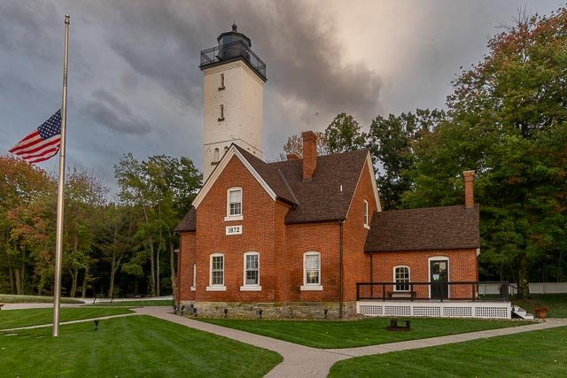
Knox Covered Bridge     A History of the Knox Covered Bridge Originally built in 1851 at a cost of $843, its span was 50 feet. The bridge was made of white pine, light in weight and resistant to worms and weather. Like other covered bridges, it was covered for protection from the weather, to keep off the rain, snow and sun. The superstructure over the bridge kept water out of the joints, where it might freeze during the winter or cause rotting in the summer, and also kept the bridge from drying. The 1851 bridge was washed away in 1865 by a flood. A replacement was built that year at a cost of $1,179. With slightly longer a 65-foot span. In 1958 the bridge was damaged by fire. When it was rebuilt by the State, steel girders were added to reinforce and strengthen it. For many years the bridge was known as the Valley Forge Dam Bridge. In the 19th century there were a number of mills and factories along The Valley Creek with a dam near what is now Route 23 providing water power for their operation. The lake formed by the dam was a “very pretty body of water” but with the water level only a foot or so below the road, it also caused flooding from time to time. Today the bridge is usually identified as the Knox Bridge – though there is some disagreement over which Knox its name is taken; Senator Philander C. Knox or General Henry Knox. It seems more probable that it took its name from the former. In 1903 he purchased 256 acres of land adjacent to the bridge and moved into the old farm house west of the bridge that had been the quarters of General William Maxwell during the Valley Forge encampment. He was an attorney and prominent in the Republican party in the early years of the 20th century, serving as Attorney General under President Theodore Roosevelt and as the Secretary of State in the cabinet of President William Howard Taft. He also served two terms as a United States Senator from Pennsylvania. The suggestion that the bridge may have been named for General Henry Knox stems from the fact that, during the Valley Forge encampment, the 300-pound commander of the Continental artillery had his quarters in the old farm house to the east of the bridge. Where it is: Knox Covered Bridge in Valley Forge National Historical Park across Valley Run (creek) near Lord Stirling’s Quarters. On (or at the end of) Yellow Springs Road as it joins Valley Creek Road (PA 252). Confusingly, the last bit of Yellow Springs Road, and part of 252 are also known as Baptist Road. Maps: Interactive Google Map Use the map  + – controls to zoom in and out, click and drag the to move the map, use the Map drop-down to change to “Map”, “Satellite”, “Hybrid”, or “Terrain” views.  Drag the little man icon from the upper left corner to a map location for street level view. GPS: 40°5’13.914″ N 75°27’23.262″ W Cost: Entry to Valley Forge National Historical Park is free of charge.   Hours: Open daily, year-round 7 AM to dark Facilities: Restrooms, snacks and refreshments are available to the visitor center. Knox Covered Bridge Photo Gallery Click Here for full page gallery   More Photographic Destinations in Pennsylvania Interactive Google Map Use the map  + – controls to zoom in and out, use the Map drop-down to change to “Map”, “Satellite”, “Hybrid”, or “Terrain” views.  Drag the little man icon from the upper left corner to a map location for street level view. Click on a pushpin for more information about the Photographic Destination, then click on the title to go to the location page. Click Here for Photographic Destinations by State    [...]Read more...
Hopewell Furnace National Historic Site Hopewell Furnace National Historic Site in southeastern Berks County, near Elverson, Pennsylvania, is an example of an American 19th century rural iron plantation, whose operations were based around a charcoal-fired cold-blast iron blast furnace. The significant restored structures include the furnace group (blast furnace, water wheel, blast machinery, cast house and charcoal house), as well as the ironmaster’s house, a company store, the blacksmith’s shop, a barn and several worker’s houses. Hopewell Furnace was founded about 1771 by ironmaster Mark Bird, son of William Bird, who had been one of Pennsylvania’s most prominent ironmasters. The site’s most prosperous time was during the 1820-1840 period with a brief return to significant production during the American Civil War. In the mid-19th century, changes in iron making, including a shift from charcoal-fueled furnaces to anthracite-fueled steel mills, rendered smaller furnaces like Hopewell obsolete. The site discontinued operations in 1883. In 1938, the property was designated Hopewell Village National Historic Site under the authority of the Historic Sites Act, thereby becoming one of the earliest cultural units of the National Park System. Today, Hopewell Furnace consists of 14 restored structures, 52 features on the List of Classified Structures, and a total of 848 mostly wooded acres. Hopewell Furnace National Historic Site is located in the Hopewell Big Woods and bordered by French Creek State Park on three sides and State Game Lands 43 on the south side, which preserves the lands the furnace utilized for its natural resources. Where it is: Park Address: 2 Mark Bird Lane, Elverson, PA 19520 Directions From the North: US Route 422 to PA Route 345. Turn onto Route 345 South and travel 6.6 miles through the town of Birdsboro and French Creek State Park until you reach the park entrance. From the East: PA Turnpike (I-76) West to exit 312 (Downingtown). Take PA Route 100 North 9 miles to PA Route 23. Turn left onto Route 23 West and travel 7 miles to PA Route 345. Turn right onto Route 345 North 4 miles to the park entrance. From the South: I-95 North to PA Turnpike (I-76). PA Turnpike West to exit 312 (Downingtown). Take PA Route 100 North and travel 9 miles to PA Route 23. Turn left onto Route 23 West and travel 7 miles to PA Route 345. Turn right onto Route 345 North and travel 4 miles to the park entrance. From the West: PA Turnpike (I-76) East to exit 298 (Morgantown). Turn onto PA Route 10 South and travel 1 mile to PA Route 23. Turn left onto Route 23 East and travel 5.3 miles to PA Route 345. Turn left onto Route 345 North and travel 4 miles to the park entrance. GPS: Latatude: 40.20667 Longitude: -75.767660 Hours: Sunday:9:00 AM–5:00 PM Monday and Tuesday:Closed Wednesday-Saturday:9:00 AM–5:00 PM Hopewell Furnace National Historic Site is open Wednesday through Sunday from 9:00AM to 5:00PM. On days the park is closed, its historic buildings, parking lot and visitor center are unavailable for use, but its trails (which interconnect with trails from French Creek State Park) remain open. Cost: There are no fees to access Hopewell Furnace National Historic Site. Location Contact Information: Mailing Address: Hopewell Furnace NHS 2 Mark Bird Lane Elverson, PA 19520 Phone: 610 582-8773 Fax 610-582-2768 Facilities: Public restrooms are located outside on the lower level of the Visitor Center. A water fountain with a bottle filling station and doggie drinking station is located just outside the restrooms. Hopewell Furnace National Historic Site Photo Gallery Click Here for full page gallery     More Photographic Destinations in Pennsylvania Interactive Google Map Use the map  + – controls to zoom in and out, use the Map drop-down to change to “Map”, “Satellite”, “Hybrid”, or “Terrain” views.  Drag the little man icon from the upper left corner to a map location for street level view. Click on a pushpin for more information about the Photographic Destination, then click on the title to go to the location page. Click Here for Photographic Destinations by State All the information in this post was believed to be accurate at the time it was published.  Please be sure to double check with the location before relying on this information as everything changes over time, especially hours, prices, and whether the location is still open.   Great Places for Great Photos   Let me help you to find a great location for your next photography adventure.  I will list many lesser-known destinations, as well as the famous "Icon Locations" for photography.  I will provide photos (Lots of Photos), location information, consisting of what there is to photograph as well as other information about the destination.  I will give costs, maps, directions, contact information, and other essential information for a successful photo trip.  I will only post for locations that I have personally photographed to ensure a quality guide to great locations for photography. If you know of great places that are not posted, please send me the details, I may just decide that is a place I need to go!     Greg Disch is a freelance photographer located in Arkansas. Greg specializes in nature, scenic, wildlife, and other outdoor subjects in Arkansas and other areas of the country.  Most of the images on this site are available for sale as prints, personal use, or rights managed stock photos. Greg offers both classroom instruction and in the field hands on photographic workshops. Classroom sessions are normally held in Fort Smith Arkansas, but arrangements can be made to bring a class to your group. All classes and workshops have small class sizes designed to provide an optimum student to instructor ratio, where you can get the personal attention, you need.  Most classes and workshops are limited to a maximum of six participants and will be held with a minimum of only two. If you are looking for a wonderful opportunity to get personal individual instruction, I do private workshops and classes at a location of your choice, whether doing a location photo shoot, coming to your home or business, traveling across the country on a road trip, or at my classroom.  This is a fantastic way to learn digital workflow and be sure that your computer equipment is properly configured for optimum performance. [...]Read more...
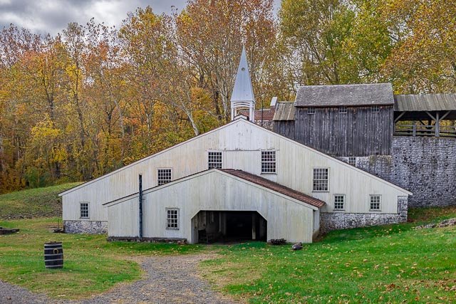
Erie Land Lighthouse The Erie Land Lighthouse, as it is now commonly referred to, was the first commissioned lighthouse along the Great Lakes in the United States. The light was positioned on a cliff overlooking the entrance to Presque Isle Bay, which is now the foot of Lighthouse Street in Erie, PA. The original structure was a 20-foot-high square wooden tower with an enclosed lantern room. The lamp that would light the way for ships was a nine-lamp array that was fueled by oil. The lighthouse’s location was strategically chosen at the entrance of what was then an ‘s’ shaped entrance to the bay and the port of Erie. Presque Isle is a dynamic landmass, called a sandspit, that changes over time. In the early 1800s, submerged sandbars made the bay nearly impassable. A proposal to engineer a uniform channel depth was made to Congress around the same time at funds were secured to construction the Land Lighthouse. This lighthouse aided travelers for nearly 50 years before the structure began to fail. Over time, the lighthouse started to lean. Metal bands were placed around the light to attempt to stabilize it, but these efforts for unsuccessful and it was clear the tower needed to be replaced. The lighthouse operated until 1880 when, based on the recommendation of the inspector of the Tenth Lighthouse District, it was discontinued. The property then fell into private hands for a short time until, after public protest, Congress appropriated $7,000 for the reestablishment of the lighthouse in 1884. The light remained active until 1899 when it was finally closed. The lens and lantern room were removed and taken to Marblehead Lighthouse in Sandusky, OH. Today, the Erie Land Lighthouse has been restored thanks to the efforts of the City of Erie and the Erie Port Authority. While no longer an active aid to navigation, the site provides spectacular views of Lake Erie and Presque Isle and is open to visitors seasonally.   Where it is: Located at the foot of Lighthouse St, in Erie, PA 2 Lighthouse St., Erie, PA 16507 Maps: Interactive Google Map Use the map  + – controls to zoom in and out, click and drag the to move the map, use the Map drop-down to change to “Map”, “Satellite”, “Hybrid”, or “Terrain” views.  Drag the little man icon from the upper left corner to a map location for street level view.   Cost: Erie Land Lighthouse Tower Climb $6, Free for Members Includes self-guided access to grounds Available every 20-minutes, no reservation required Must be 44″ tall to climb Links: Erie Land Lighthouse GPS: 42°8’38.352″ N 80°3’44.49″ W Hours: Open for the summer season The Erie Land Lighthouse will be open Fridays through Mondays from 10 a.m. to 3 p.m. through Memorial Day and then will be open Fridays through Mondays from 10 a.m. to 5 p.m. through Labor Day. Grounds open dawn to dusk. Closed July 4th and August 17th Location Contact Information: Two Lighthouse St. Erie, PA 16507   (814) 452-3937 Erie Land Lighthouse Photo Gallery Click Here for full page gallery     More Photographic Destinations in Pennsylvania Interactive Google Map Use the map  + – controls to zoom in and out, use the Map drop-down to change to “Map”, “Satellite”, “Hybrid”, or “Terrain” views.  Drag the little man icon from the upper left corner to a map location for street level view. Click on a pushpin for more information about the Photographic Destination, then click on the title to go to the location page. Click Here for Photographic Destinations by State All the information in this post was believed to be accurate at the time it was published.  Please be sure to double check with the location before relying on this information as everything changes over time, especially hours, prices, and whether the location is still open.   Great Places for Great Photos   Let me help you to find a great location for your next photography adventure.  I will list many lesser-known destinations, as well as the famous "Icon Locations" for photography.  I will provide photos (Lots of Photos), location information, consisting of what there is to photograph as well as other information about the destination.  I will give costs, maps, directions, contact information, and other essential information for a successful photo trip.  I will only post for locations that I have personally photographed to ensure a quality guide to great locations for photography. If you know of great places that are not posted, please send me the details, I may just decide that is a place I need to go!     Greg Disch is a freelance photographer located in Arkansas. Greg specializes in nature, scenic, wildlife, and other outdoor subjects in Arkansas and other areas of the country.  Most of the images on this site are available for sale as prints, personal use, or rights managed stock photos. Greg offers both classroom instruction and in the field hands on photographic workshops. Classroom sessions are normally held in Fort Smith Arkansas, but arrangements can be made to bring a class to your group. All classes and workshops have small class sizes designed to provide an optimum student to instructor ratio, where you can get the personal attention, you need.  Most classes and workshops are limited to a maximum of six participants and will be held with a minimum of only two. If you are looking for a wonderful opportunity to get personal individual instruction, I do private workshops and classes at a location of your choice, whether doing a location photo shoot, coming to your home or business, traveling across the country on a road trip, or at my classroom.  This is a fantastic way to learn digital workflow and be sure that your computer equipment is properly configured for optimum performance. [...]Read more...