Fort McHenry National Monument

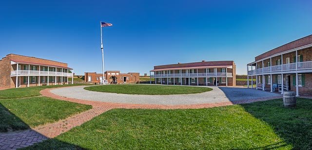
Fort McHenry is a historical American coastal pentagonal bastion fort on Locust Point, now a neighborhood of Baltimore, Maryland. It is best known for its role in the War of 1812, when it successfully defended Baltimore Harbor from an attack by the British navy from Chesapeake Bay on September 13–14, 1814.
The fort was built in 1798 and was used continuously by U.S. armed forces through World War I and by the United States Coast Guard in World War II. It was designated a national park in 1925, and, in 1939, was redesignated a U.S. National Monument.
During the War of 1812, an American storm flag, 17 by 25 feet (5.2 m × 7.6 m), was flown over Fort McHenry during the British bombardment of the fort. The flag was replaced early on the morning of September 14, 1814, with a larger American garrison flag, 30 by 42 feet. The larger flag signaled American victory over the British in the Battle of Baltimore.
The sight of the ensign inspired Francis Scott Key to write the poem “Defence of Fort M’Henry” that was later set to music in the song “To Anacreon in Heaven”, which was later known and designated as “The Star-Spangled Banner”, the national anthem of the United States.
Where it is:
The park is three miles southeast of the Baltimore Inner Harbor and just off I-95. Follow the brown Fort McHenry directional signs along all major routes to the park. From I-95 northbound, take Exit 55 to Key Highway and follow Fort McHenry signs. From I-95 southbound, as you approach the Fort McHenry Tunnel, move to the toll booths on the far right as you will be exiting immediately after emerging from the tunnel. Take Exit 55 to Key Highway and follow the Fort McHenry signs using Lawrence Street and not Woodall, as your GPS might indicate.
From the Inner Harbor, take Light Street south to Key Highway. Turn left and follow the Fort McHenry signs to Lawrence Street. Turn right on Lawrence Street and then left on Fort Avenue to the park.
The most direct route to Fort McHenry is I-95. Take Exit 55 and drive to the light at Key Highway. Follow the signs to the fort.
At the third light on Key Highway, turn left onto Lawrence Street. Turn left at the next light and Fort Avenue will bring you to Fort McHenry.
GPS:
39°15’54.894″ N 76°34’47.61″ W
Hours:
Standard Hours
- Every Day:9:00 AM–5:00 PM
Park Grounds and Parking lot: 8:00 a.m. – 5:00 p.m. Star Fort, Visitor Center, gift shop, and restrooms close 15 minutes before the park closes. Closing times indicate when the gates will be close; all visitors must exit by this time.
Summer Hours
- Sunday:9:00 AM–6:00 PM
- Monday-Friday:9:00 AM–5:00 PM
- Saturday:9:00 AM–6:00 PM
Cost:
All visitors must have one of these entrance passes:
Standard Pass $15.00
Annual Pass $45.00
America the Beautiful Pass (includes Senior Passes) FREE–$80.00
Location Contact Information:
Mailing Address:
2400 East Fort Avenue
Baltimore, MD 21230
Phone:
410 962-4290 x250
Facilities:
The Paul S. Sarbanes Visitor and Education Center is open daily from 9:00 am – 4:45 pm. Inside the visitor center is an introductory museum, a movie (plays every 30 minutes), the park bookstore, restrooms, and water bottle filling station.
Click Here for full page gallery
More Photographic Destinations in Maryland
Interactive Google Map
Use the map + – controls to zoom in and out, use the Map drop-down to change to “Map”, “Satellite”, “Hybrid”, or “Terrain” views. Drag the little man icon from the upper left corner to a map location for street level view. Click on a pushpin for more information about the Photographic Destination, then click on the title to go to the location page.