Shoshone Falls

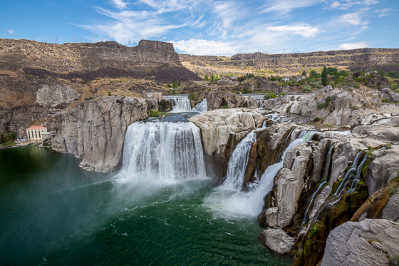
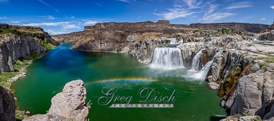
Shoshone Falls is a waterfall on the Snake River in southern Idaho, approximately 3 miles northeast of the city of Twin Falls. Sometimes called the “Niagara of the West,” Shoshone Falls is 212 feet high—45 feet higher than Niagara Falls—and flows over a rim nearly 1,000 feet wide.
Formed by catastrophic outburst flooding during the Pleistocene ice age about 14,000 years ago, Shoshone Falls marks the historical upper limit of fish migration (including salmon) in the Snake River, and was an important fishing and trading place for Native Americans. The falls were documented by Europeans as early as the 1840s; despite the isolated location, it became a tourist attraction starting in the 1860s. At the beginning of the 20th century, part of the Snake River was diverted for irrigation of the Magic Valley. Now, the flows over the falls can be viewed seasonally based on snowfall, irrigation needs and hydroelectric demands. Irrigation and hydroelectric power stations built on the falls were the primary contributors to early economic development in southern Idaho.
The City of Twin Falls owns and operates a park overlooking the waterfall. The flow over the falls ranges from over 20,000 cubic feet per second during late spring of wet years, to a minimum “scenic flow” (dam release) of 300 cubic feet per second in dry years.
What to Photograph:
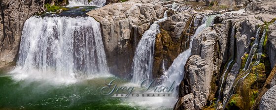
The spectacular waterfalls and the Snake River below.
Best Time for Photographers:
Shoshone Falls is best viewed in the spring, as diversion of the Snake River often significantly diminishes water levels in the late summer and fall.
Where it is:
Shoshone Falls is a waterfall on the Snake River in southern Idaho, United States, approximately 3 miles northeast of the city of Twin Falls.
Shoshone Falls
Falls Ave, 1 1/4 mile north on 3300 East
Twin Falls, ID 83301
Maps:
Interactive Google Map
Use the map + – controls to zoom in and out, click and drag the to move the map, use the Map drop-down to change to “Map”, “Satellite”, “Hybrid”, or “Terrain” views. Drag the little man icon from the upper left corner to a map location for street level view.
GPS:
42°35’38.303″ N 114°24’6.173″ W
Cost:
The cost for admission at Shoshone Falls Park is $3.00 per car (subject to change).
Parks and Recreation begins charging admission each year on March 30 and continues through September.
Season passes to Shoshone Falls are $25 and are available to purchase at the Parks and Recreation Department building and the ticket booth at Shoshone Falls.
Facilities:
The falls offer a unique blend of recreational facilities, including playgrounds, hiking trails, picnic areas, a boat ramp, swimming area, and a scenic overlook. A picnic in the shaded, grassy areas provides a perfect vantage point for viewing Shoshone Falls.
Amenities
11 grills
Alcohol consumption prohibited on boat docks
Boat launch to Snake River
Concession stand
Drinking fountain
No electricity available
Picnic tables
Restrooms
Shoshone Falls overlook
Trails
Links:
Location Contact Information:

Mailing Address
P.O. Box 1907 | Twin Falls, ID 83303
Physical Address
203 Main Ave. East | Twin Falls, ID 83301
Emergency 9-1-1
Non-Emergency (208) 735-4357
City Hall (208) 735-7287
Fax (208) 736-2296
Shoshone Falls Photo Gallery
Click Here for full page gallery
More Photographic Destinations in Idaho:
Interactive Google Map
Use the map + – controls to zoom in and out, use the Map drop-down to change to “Map”, “Satellite”, “Hybrid”, or “Terrain” views. Drag the little man icon from the upper left corner to a map location for street level view. Click on a pushpin for more information about the Photographic Destination, then click on the title to go to the location page.
Click Here for Photographic Destinations by State


