New Hampshire Photographic Destinations

Swiftwater Covered Bridge Rocky Gorge Scenic Area Albany Covered Bridge Groveton Covered Bridge Madame Sherri's Castle

Let me help you to find a great location in New Hampshire for your next photography adventure.  I will list many lesser known destinations, as well as the famous “Icon Locations” for photography.  I will provide photos (Lots of Photos), location information,  consisting of what there is to photograph as well as other information about the destination.  I will give costs, maps, directions, contact information, and other essential information for a successful photo trip.  I will only post for locations that I have personally photographed to insure a quality guide to great locations for photography in New Hampshire.

Interactive Google Map

Use the map  + – controls to zoom in and out, use the Map drop-down to change to “Map”, “Satellite”, “Hybrid”, or “Terrain” views.  Drag the little man icon from the upper left corner to a map location for street level view. Click on a pushpin for more information about the Photographic Destination, then click on the title to go to the location page.

New Hampshire Photographic Destinations

New Hampshire Destinations
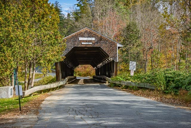
Swiftwater Covered Bridge The Swiftwater Covered Bridge is a historic covered bridge which carries Porter Road over the Wild Ammonoosuc River in Bath, New Hampshire. Built in 1849, it is one of New Hampshire’s few surviving 19th-century covered bridges, and a well-preserved example of the Paddleford truss design. The bridge was added to the National Register of Historic Places in 1976. It is a locally distinctive single-span Paddleford truss design, with laminated arches and steel beam reinforcements added in the 20th century. The bridge has an overall length of 173’8″ and two clear spans of 77’6″ and 57’6″. The roadbed is 14’6″ wide, with a vertical clearance of 12’9″. It rests on lightly-mortared split granite abutments topped with concrete footings. The roof is made of corrugated metal, and the sides are sheathed in vertical planking to a height of eight feet, leaving an exposed area above. Its portals are also covered in vertical planking, but do not extend all the way to the ground. The bridge, the fourth on the site, was built in 1849; the first two bridges, dating back to 1810, were washed away by floods. It was probably built under the auspices of Joseph Fifield and John Carbee, town officials responsible for its highways and bridges. Its design, an unpatented truss by New Hampshire native Peter Paddleford, may have been used due to local connections with Paddleford associates. The bridge is said to have survived the use of explosives to clear logjams in the area. Where it is: The Swiftwater Covered Bridge is located in southeastern Bath, carrying Porter Road over the Wild Ammonoosuc River just north of New Hampshire Route 112.   GPS: 44°8’2.2287″ N 71°57’2.7203″ W Hours: The Swiftwater Covered Bridge is on a public road and is always open. Cost: There is no cost to visit the bridge. Location Contact Information: The bridge is owned by the town of Bath New Hampshire. Facilities: There are no facilities at the bridge. Photo Gallery Click Here for full page gallery     More Photographic Destinations in New Hampshire Interactive Google Map Use the map  + – controls to zoom in and out, use the Map drop-down to change to “Map”, “Satellite”, “Hybrid”, or “Terrain” views.  Drag the little man icon from the upper left corner to a map location for street level view. Click on a pushpin for more information about the Photographic Destination, then click on the title to go to the location page. Click Here for Photographic Destinations by State All the information in this post was believed to be accurate at the time it was published.  Please be sure to double check with the location before relying on this information as everything changes over time, especially hours, prices, and whether the location is still open.   Great Places for Great Photos   Let me help you to find a great location for your next photography adventure.  I will list many lesser-known destinations, as well as the famous "Icon Locations" for photography.  I will provide photos (Lots of Photos), location information, consisting of what there is to photograph as well as other information about the destination.  I will give costs, maps, directions, contact information, and other essential information for a successful photo trip.  I will only post for locations that I have personally photographed to ensure a quality guide to great locations for photography. If you know of great places that are not posted, please send me the details, I may just decide that is a place I need to go!     Greg Disch is a freelance photographer located in Arkansas. Greg specializes in nature, scenic, wildlife, and other outdoor subjects in Arkansas and other areas of the country.  Most of the images on this site are available for sale as prints, personal use, or rights managed stock photos. Greg offers both classroom instruction and in the field hands on photographic workshops. Classroom sessions are normally held in Fort Smith Arkansas, but arrangements can be made to bring a class to your group. All classes and workshops have small class sizes designed to provide an optimum student to instructor ratio, where you can get the personal attention, you need.  Most classes and workshops are limited to a maximum of six participants and will be held with a minimum of only two. If you are looking for a wonderful opportunity to get personal individual instruction, I do private workshops and classes at a location of your choice, whether doing a location photo shoot, coming to your home or business, traveling across the country on a road trip, or at my classroom.  This is a fantastic way to learn digital workflow and be sure that your computer equipment is properly configured for optimum performance. [...]Read more...
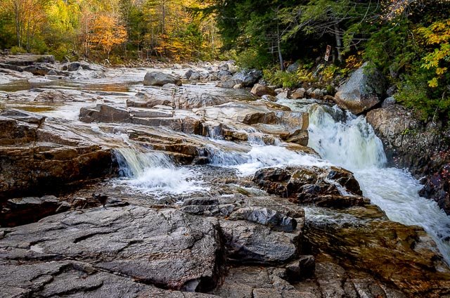
Rocky Gorge Scenic Area Rocky Gorge is a waterfall and the name of a scenic and picnic area along the Swift River in the White Mountain National Forest of New Hampshire, United States, next to the Kancamagus Highway. Rocky Gorge is a powerful narrow gorge that was carved by glaciers, and offers a 10′ drop and rapids throughout. This beautiful scenic area is accessed by a short walk along a paved walkway from the large parking area off of the Kancamagus Highway. There is a foot bridge over the gorge which provides an excellent photo opportunity looking upstream to where the Swift River cascades into the gorge. The foot path on the other side of the bridge gradually ascends a small rise to Falls Pond. There is a mile long trail around the pond which is a popular fishing area. Rocky Gorge accessible to those with disabilities. Swimming in or jumping into the gorge is prohibited and is strictly enforced. Where it is: Located eight miles west of Conway on the Kancamagus Highway. Kancamagus Highway Albany, NH 03818 GPS: 44°0’14.898″ N 71°16’40.224″ W Hours: Mid-May – mid-October Cost: There is a $5.00 recreation fee to park Location Contact Information: White Mountain National Forest Supervisor’s Office 71 White Mountain Drive Campton, NH 03223 (603) 536-6100 TTY: 711 Facilities: There are no restrooms or potable water at this location. There are picnic tables. Rocky Gorge Scenic Area Photo Gallery Click Here for full page gallery     More Photographic Destinations in New Hampshire Interactive Google Map Use the map  + – controls to zoom in and out, use the Map drop-down to change to “Map”, “Satellite”, “Hybrid”, or “Terrain” views.  Drag the little man icon from the upper left corner to a map location for street level view. Click on a pushpin for more information about the Photographic Destination, then click on the title to go to the location page. Click Here for Photographic Destinations by State All the information in this post was believed to be accurate at the time it was published.  Please be sure to double check with the location before relying on this information as everything changes over time, especially hours, prices, and whether the location is still open.   Great Places for Great Photos   Let me help you to find a great location for your next photography adventure.  I will list many lesser-known destinations, as well as the famous "Icon Locations" for photography.  I will provide photos (Lots of Photos), location information, consisting of what there is to photograph as well as other information about the destination.  I will give costs, maps, directions, contact information, and other essential information for a successful photo trip.  I will only post for locations that I have personally photographed to ensure a quality guide to great locations for photography. If you know of great places that are not posted, please send me the details, I may just decide that is a place I need to go!     Greg Disch is a freelance photographer located in Arkansas. Greg specializes in nature, scenic, wildlife, and other outdoor subjects in Arkansas and other areas of the country.  Most of the images on this site are available for sale as prints, personal use, or rights managed stock photos. Greg offers both classroom instruction and in the field hands on photographic workshops. Classroom sessions are normally held in Fort Smith Arkansas, but arrangements can be made to bring a class to your group. All classes and workshops have small class sizes designed to provide an optimum student to instructor ratio, where you can get the personal attention, you need.  Most classes and workshops are limited to a maximum of six participants and will be held with a minimum of only two. If you are looking for a wonderful opportunity to get personal individual instruction, I do private workshops and classes at a location of your choice, whether doing a location photo shoot, coming to your home or business, traveling across the country on a road trip, or at my classroom.  This is a fantastic way to learn digital workflow and be sure that your computer equipment is properly configured for optimum performance. [...]Read more...
Madame Sherri’s Castle The Madame Sherri Forest is named after a former owner, Madame Antoinette Sherri, a Paris-born theatrical costume designer who worked in New York City during the early 1900s. She and her husband built a French-inspired chateau summer house in Chesterfield that featured extensive stonework including a roman arch stairway, ornate interior, and designed landscape gardens. There they lavishly entertained their New York City friends at parties during the Roaring 1920s. Madame Sherri became famous – or infamous – for her wild parties. However, in time Madame Sherri’s fortunes declined, and her castle fell to ruin and vandalism. After a long separation, she returned to the house in 1959 to find the interior badly vandalized. She left, heartbroken, never to return again. The house burned down completely in 1963. Today, ancient sugar maples surround a stone foundation and stairway, a large empty fireplace tapers to a freestanding chimney. This is all that remains of the former summer home of Madame Sherri who died in Brattleboro Vermont on October 21, 1965. What to Photograph The ruins of Madame Sherri’s home or “Castle” including what is referred to as the “Stairway to Heaven” along with the beautiful Madame Sherri Forest.         Where it is: The Madame Sherri Forest is located on the Gulf Road. Coming from the east on Rt. 9 take Rt. 63 south through Chesterfield Village past the town hall. At approx. 1.6 miles from Rt. 9 take a right on Stage Rd. and then shortly after bear left onto Castle Rd. Castle Rd will join Gulf Rd and continues to the Madame Sherri Forest approx. 2.6 miles from Rt. 63. The entrance on the left is notable for a red steel gate. From the west take a right just after the Riverside Store along the Connecticut River. Gulf Rd. bears quickly off to the left and continues approx. 2.2 miles to the forest entrance. All nonmotorized travel is welcomed on the trails. From the parking lot, the foundation, chimneys, and grand stone staircase of the former Madame Sherri “castle” are just 100 feet up a short side trail. Maps: Interactive Google Map Use the map  + – controls to zoom in and out, click and drag the to move the map, use the Map drop-down to change to “Map”, “Satellite”, “Hybrid”, or “Terrain” views.  Drag the little man icon from the upper left corner to a map location for street level view. GPS: 42°51’52.999″ N 72°31’10” W   Cost: There is no cost to access the Madame Sherri Forest or the ruins of  Madame Sherri’s Castle. RESTRICTIONS No wheeled vehicles (including Bicycles) No Motorized wheeled vehicles (ATVs, trucks, dirt bikes) No Camping No Fires Carry in, Carry out all trash Do not disturb plants, animals, or cultural features No guaranteed winter access Hours: The location is always open, however it may not be accessible in winter. Facilities: There are no facilities at this location. Location Contact Information: Society for the Protection of New Hampshire Forests 54 Portsmouth St.Concord, NH 03301 Phone: 603.224.9945 Fax: 603.228.0423 info@forestsociety.org Madame Sherri’s Castle Photo Gallery Click Here for full page gallery   More Photographic Destinations in New Hampshire: Interactive Google Map Use the map  + – controls to zoom in and out, use the Map drop-down to change to “Map”, “Satellite”, “Hybrid”, or “Terrain” views.  Drag the little man icon from the upper left corner to a map location for street level view. Click on a pushpin for more information about the Photographic Destination, then click on the title to go to the location page. Click Here for Photographic Destinations by State    All the information in this post was believed to be accurate at the time it was published.  Please be sure to double check with the location before relying on this information as everything changes over time, especially hours, prices, and whether the location is still open.   Great Places for Great Photos   Let me help you to find a great location for your next photography adventure.  I will list many lesser-known destinations, as well as the famous "Icon Locations" for photography.  I will provide photos (Lots of Photos), location information, consisting of what there is to photograph as well as other information about the destination.  I will give costs, maps, directions, contact information, and other essential information for a successful photo trip.  I will only post for locations that I have personally photographed to ensure a quality guide to great locations for photography. If you know of great places that are not posted, please send me the details, I may just decide that is a place I need to go!     Greg Disch is a freelance photographer located in Arkansas. Greg specializes in nature, scenic, wildlife, and other outdoor subjects in Arkansas and other areas of the country.  Most of the images on this site are available for sale as prints, personal use, or rights managed stock photos. Greg offers both classroom instruction and in the field hands on photographic workshops. Classroom sessions are normally held in Fort Smith Arkansas, but arrangements can be made to bring a class to your group. All classes and workshops have small class sizes designed to provide an optimum student to instructor ratio, where you can get the personal attention, you need.  Most classes and workshops are limited to a maximum of six participants and will be held with a minimum of only two. If you are looking for a wonderful opportunity to get personal individual instruction, I do private workshops and classes at a location of your choice, whether doing a location photo shoot, coming to your home or business, traveling across the country on a road trip, or at my classroom.  This is a fantastic way to learn digital workflow and be sure that your computer equipment is properly configured for optimum performance. [...]Read more...
  Groveton Covered Bridge The Groveton Covered Bridge is located in Groveton Village, in the town of Northumberland. Built in 1852 by Captain Charles Richardson and his son, the Groveton Bridge is 126 feet long, has a clear span of just over 108 feet, and its overall width is 21 feet. The bridge spans the upper Ammonoosuc River, and connects Route 3 in Northumberland to Route 110 in Groveton. The Groveton Bridge is an example of a Paddleford truss bridge, a truss style developed by Peter Paddleford of Littleton, New Hampshire. The Paddleford truss, found only in New England, is an unpatented regional variant of the Long truss style that was originally developed by Stephen H. Long. The Long truss is made entirely of wood and the diagonal members are under compression while vertical members are in tension. The fact that almost all Paddleford truss bridges, including the Groveton Covered Bridge, eventually required strengthening suggests an inherent design flaw. Fortunately, the flaws were able to be remediated with relative ease by adding Burr arches to the structures. The Burr arch, invented in 1804 by Theodore Burr, is a combination of an arch and multiple kingposts, one of the simplest truss styles consisting of two angled supports leaning into a common vertical support. The Groveton Bridge was bypassed following the reconstruction of Route 3 in 1939. Covered bridge restoration experts, Milton Graton and his son, Arnold, repaired the bridge between the years of 1964 and 1965. Historically, covered bridges were a popular infrastructure investment towns made throughout New England and the northeast. Timber was an abundant resource, and the remote location of the desired crossing often necessitated a small bridge. The humid Northeastern climate favored wooden construction, and in order to keep a wooden bridge sound for a much longer period of time, the bridge was constructed with a roof which protected it from the elements, allowing a covered bridge to be used for a century or more. The Groveton Covered Bridge is no exception, as the bridge has remained a sound structure (with repairs) for over 160 years. Where it is: East of U.S. Route 3 in the village of Groveton/Northumberland New Hampshire over the Ammonoosue River.   Maps: Interactive Google Map Use the map  + – controls to zoom in and out, click and drag the to move the map, use the Map drop-down to change to “Map”, “Satellite”, “Hybrid”, or “Terrain” views.  Drag the little man icon from the upper left corner to a map location for street level view.   GPS: 44°35’44.502″ N 71°30’39.282″ W Cost: There is no cost to visit the bridge. Hours: The bridge is accessible at any time. Facilities: There is a picnic area at the bridge, there are no restroom facilities.  The bridge is located on the edge of town where there are restaurants and stores. Location Contact Information:  The bridge is maintained by the town of Northumberland New Hampshire PO Box 128 17 Catherine Street Gansevoort, NY 12831 (518)792-9179 Groveton Covered Bridge Photo Gallery Click Here for full page gallery   More Photographic Destinations in New Hampshire Interactive Google Map Use the map  + – controls to zoom in and out, use the Map drop-down to change to “Map”, “Satellite”, “Hybrid”, or “Terrain” views.  Drag the little man icon from the upper left corner to a map location for street level view. Click on a pushpin for more information about the Photographic Destination, then click on the title to go to the location page. Click Here for Photographic Destinations by State    All the information in this post was believed to be accurate at the time it was published.  Please be sure to double check with the location before relying on this information as everything changes over time, especially hours, prices, and whether the location is still open.   Great Places for Great Photos   Let me help you to find a great location for your next photography adventure.  I will list many lesser-known destinations, as well as the famous "Icon Locations" for photography.  I will provide photos (Lots of Photos), location information, consisting of what there is to photograph as well as other information about the destination.  I will give costs, maps, directions, contact information, and other essential information for a successful photo trip.  I will only post for locations that I have personally photographed to ensure a quality guide to great locations for photography. If you know of great places that are not posted, please send me the details, I may just decide that is a place I need to go!     Greg Disch is a freelance photographer located in Arkansas. Greg specializes in nature, scenic, wildlife, and other outdoor subjects in Arkansas and other areas of the country.  Most of the images on this site are available for sale as prints, personal use, or rights managed stock photos. Greg offers both classroom instruction and in the field hands on photographic workshops. Classroom sessions are normally held in Fort Smith Arkansas, but arrangements can be made to bring a class to your group. All classes and workshops have small class sizes designed to provide an optimum student to instructor ratio, where you can get the personal attention, you need.  Most classes and workshops are limited to a maximum of six participants and will be held with a minimum of only two. If you are looking for a wonderful opportunity to get personal individual instruction, I do private workshops and classes at a location of your choice, whether doing a location photo shoot, coming to your home or business, traveling across the country on a road trip, or at my classroom.  This is a fantastic way to learn digital workflow and be sure that your computer equipment is properly configured for optimum performance. [...]Read more...
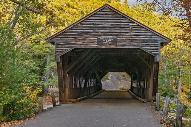
  Albany Covered Bridge The Albany Covered Bridge is also known  as “White Mountain National Forest Bridge. The Albany Covered Bridge is a historic bridge located in the White Mountains near the Kancamagus Highway. Albany Covered Bridge was built in 1858 but destroyed by a storm which flooded the Swift River and swept away the new bridge. The bridge was quickly rebuilt and remained usable for over 100 years before needing to be renovated in 1970. This covered bridge was constructed in 1858 and spans 120 feet across the Swift River in central New Hampshire. After its renovation in the late 1900s, the Albany Covered Bridge became strong enough to support vehicular traffic. This is a popular place for landscape photography, especially during the fall. The Albany Covered Bridge was first constructed in 1858. Repairs and restorations over the years have kept the bridge in the usable condition you see today. The site has a large parking lot that will accommodate buses and restrooms are available. There are several interpretive panels on both sides of the bridge and a granite fishing pier on the north side. The bridge is closed during the winter months but foot traffic is welcome. The parking lot is maintained year-round. Where it is: The Albany Covered Bridge spans the Swift River just north of the Kancamagus Highway. The bridge is actually located on Passaconaway/Dugway Road just a short distance from the Kancamagus Highway six miles west of Conway. There is a 7’ 9” height restriction for vehicles using the bridge. GPS: 44°0’20.364″ N 71°14’27.636″ W Hours: The bridge is on a public road and is open 24 hour a day. The bridge is closed during the winter months but foot traffic is welcome. Cost: No fees are required for the Albany Covered Bridge. Location Contact Information: White Mountain National Forest Supervisor’s Office 71 White Mountain Drive Campton, NH 03223 (603) 536-6100 TTY: 711 Albany Covered Bridge Photo Gallery Click Here for full page gallery     More Photographic Destinations in New Hampshire Interactive Google Map Use the map  + – controls to zoom in and out, use the Map drop-down to change to “Map”, “Satellite”, “Hybrid”, or “Terrain” views.  Drag the little man icon from the upper left corner to a map location for street level view. Click on a pushpin for more information about the Photographic Destination, then click on the title to go to the location page. Click Here for Photographic Destinations by State All the information in this post was believed to be accurate at the time it was published.  Please be sure to double check with the location before relying on this information as everything changes over time, especially hours, prices, and whether the location is still open.   Great Places for Great Photos   Let me help you to find a great location for your next photography adventure.  I will list many lesser-known destinations, as well as the famous "Icon Locations" for photography.  I will provide photos (Lots of Photos), location information, consisting of what there is to photograph as well as other information about the destination.  I will give costs, maps, directions, contact information, and other essential information for a successful photo trip.  I will only post for locations that I have personally photographed to ensure a quality guide to great locations for photography. If you know of great places that are not posted, please send me the details, I may just decide that is a place I need to go!     Greg Disch is a freelance photographer located in Arkansas. Greg specializes in nature, scenic, wildlife, and other outdoor subjects in Arkansas and other areas of the country.  Most of the images on this site are available for sale as prints, personal use, or rights managed stock photos. Greg offers both classroom instruction and in the field hands on photographic workshops. Classroom sessions are normally held in Fort Smith Arkansas, but arrangements can be made to bring a class to your group. All classes and workshops have small class sizes designed to provide an optimum student to instructor ratio, where you can get the personal attention, you need.  Most classes and workshops are limited to a maximum of six participants and will be held with a minimum of only two. If you are looking for a wonderful opportunity to get personal individual instruction, I do private workshops and classes at a location of your choice, whether doing a location photo shoot, coming to your home or business, traveling across the country on a road trip, or at my classroom.  This is a fantastic way to learn digital workflow and be sure that your computer equipment is properly configured for optimum performance. [...]Read more...