Ohio Photographic Destinations


Vermillion Lighthouse Lorain Harbor Lighthouse Fairport Harbor Lighthouse Marblehead Lighthouse Huron Harbor Lighthouse Bay Covered Bridge State Road Covered Bridge

Let me help you to find a great location in Ohio for your next photography adventure.  I will list many lesser known destinations, as well as the famous “Icon Locations” for photography.  I will provide photos (Lots of Photos), location information,  consisting of what there is to photograph as well as other information about the destination.  I will give costs, maps, directions, contact information, and other essential information for a successful photo trip.  I will only post for locations that I have personally photographed to insure a quality guide to great locations for photography in Illinois.


Interactive Google Map

Use the map  + – controls to zoom in and out, use the Map drop-down to change to “Map”, “Satellite”, “Hybrid”, or “Terrain” views.  Drag the little man icon from the upper left corner to a map location for street level view. Click on a pushpin for more information about the Photographic Destination, then click on the title to go to the location page.

Ohio Photographic Destinations

Ohio Destinations
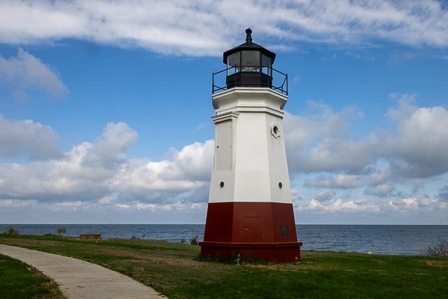
Vermillion Lighthouse The Vermilion Lighthouse is a lighthouse on the shores of Lake Erie in Vermilion, Ohio, USA. It is situated near the mouth of the Vermilion River. Erected on 23 October 1991 and dedicated on 6 June 1992, the lighthouse is illuminated by a 200 watt incandescent light bulb with a 5th order Fresnel lens. The lighthouse’s United States Coast Guard-mandated light color is steady red. The current lighthouse is a 34-foot replica of the previous Vermilion Lighthouse that had been removed in 1929. Once the lighthouse had been dismantled in 1929, it was transported to Buffalo, New York, where it was renovated. Six years later, in 1935, the lighthouse was given a new home and a new charge—on Lake Ontario. Sitting off Cape Vincent at the entrance to the Saint Lawrence Seaway, the Vermilion Lighthouse was given a fifth-order Fresnel lens and renamed East Charity Shoal Lighthouse. The light remains an active aid to navigation, with its modern optic (installed in 1992) displayed at a 52-foot focal plane. Following a multi-year fundraising campaign headed by local historian Theodore Wakefield, the replica was built by the Great Lakes Historical Society using $55,000 in public contributions. Designed by architect Robert Lee Tracht of Huron, Ohio, groundbreaking for the lighthouse occurred on 24 July 1991. Where it is: From Highway 6 in Vermilion, turn north towards the lake on Main Street. The former site of the Inland Seas Maritime Museum, where the lighthouse is located, will be on your left at the end of the street.  480 Main St, Vermilion, OH 44089 Links: Vermillion Ohio Lighthouse GPS: 41°25’28.476″ N 82°21’59.766″ W Hours: The grounds are open 24 hours, the tower is not open to the public. Cost: There is no fee to view the lighthouse. Location Contact Information: Discover Vermilion PO Box 136, Vermilion, Ohio 44089   Vermillion Lighthouse Photo Gallery Click Here for full page gallery     More Photographic Destinations in Ohio Interactive Google Map Use the map  + – controls to zoom in and out, use the Map drop-down to change to “Map”, “Satellite”, “Hybrid”, or “Terrain” views.  Drag the little man icon from the upper left corner to a map location for street level view. Click on a pushpin for more information about the Photographic Destination, then click on the title to go to the location page. Click Here for Photographic Destinations by State All the information in this post was believed to be accurate at the time it was published.  Please be sure to double check with the location before relying on this information as everything changes over time, especially hours, prices, and whether the location is still open.   Great Places for Great Photos   Let me help you to find a great location for your next photography adventure.  I will list many lesser-known destinations, as well as the famous "Icon Locations" for photography.  I will provide photos (Lots of Photos), location information, consisting of what there is to photograph as well as other information about the destination.  I will give costs, maps, directions, contact information, and other essential information for a successful photo trip.  I will only post for locations that I have personally photographed to ensure a quality guide to great locations for photography. If you know of great places that are not posted, please send me the details, I may just decide that is a place I need to go!     Greg Disch is a freelance photographer located in Arkansas. Greg specializes in nature, scenic, wildlife, and other outdoor subjects in Arkansas and other areas of the country.  Most of the images on this site are available for sale as prints, personal use, or rights managed stock photos. Greg offers both classroom instruction and in the field hands on photographic workshops. Classroom sessions are normally held in Fort Smith Arkansas, but arrangements can be made to bring a class to your group. All classes and workshops have small class sizes designed to provide an optimum student to instructor ratio, where you can get the personal attention, you need.  Most classes and workshops are limited to a maximum of six participants and will be held with a minimum of only two. If you are looking for a wonderful opportunity to get personal individual instruction, I do private workshops and classes at a location of your choice, whether doing a location photo shoot, coming to your home or business, traveling across the country on a road trip, or at my classroom.  This is a fantastic way to learn digital workflow and be sure that your computer equipment is properly configured for optimum performance. [...]Read more...
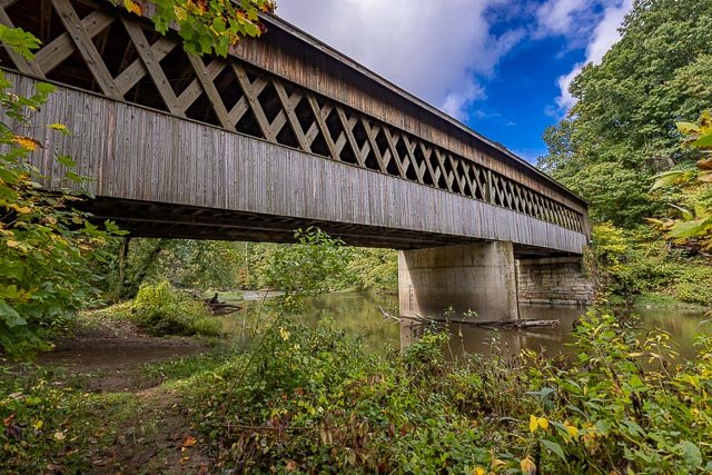
State Road Covered Bridge State Road Bridge is a covered bridge spanning Conneaut Creek in Monroe Township, Ashtabula County, Ohio, United States. The bridge, one of currently 17 drivable bridges in the county, is a single span Town truss design. Constructed of 97,000 feet of southern pine and oak, it features a 4-foot-tall window which extends the length of the bridge. This bridge was constructed in 1983. The 152-foot Town lattice span was the first covered bridge designed and built by County Engineer John Smolen, Jr. The original covered bridge was built in 1831, by Ira Benton, and David Niles, for a cost of $100. The bridge stood until 1898. The dedication of the bridge in 1983 was the forerunner of the Ashtabula County Covered Bridge Festival. Where it is: State Road Covered Bridge is located approximately 3.9 miles east-southeast of North Kingsville Ohio. 5899 State Rd., Kingsville, OH 44048 Maps: Interactive Google Map Use the map  + – controls to zoom in and out, click and drag the to move the map, use the Map drop-down to change to “Map”, “Satellite”, “Hybrid”, or “Terrain” views.  Drag the little man icon from the upper left corner to a map location for street level view. GPS: 41°53’10.362″ N 80°37’13.41″ W   Cost: There is no cost to visit. Hours: Always Open Facilities: There are no facilities at the bridge. Location Contact Information: Contact Details Phone 440-599-7697 Address 5899 State Rd., Kingsville, OH 44048 State Road Covered Bridge Photo Gallery Click Here for full page gallery   More Photographic Destinations in Ohio Interactive Google Map Use the map  + – controls to zoom in and out, use the Map drop-down to change to “Map”, “Satellite”, “Hybrid”, or “Terrain” views.  Drag the little man icon from the upper left corner to a map location for street level view. Click on a pushpin for more information about the Photographic Destination, then click on the title to go to the location page. Click Here for Photographic Destinations by State    All the information in this post was believed to be accurate at the time it was published.  Please be sure to double check with the location before relying on this information as everything changes over time, especially hours, prices, and whether the location is still open.   Great Places for Great Photos   Let me help you to find a great location for your next photography adventure.  I will list many lesser-known destinations, as well as the famous "Icon Locations" for photography.  I will provide photos (Lots of Photos), location information, consisting of what there is to photograph as well as other information about the destination.  I will give costs, maps, directions, contact information, and other essential information for a successful photo trip.  I will only post for locations that I have personally photographed to ensure a quality guide to great locations for photography. If you know of great places that are not posted, please send me the details, I may just decide that is a place I need to go!     Greg Disch is a freelance photographer located in Arkansas. Greg specializes in nature, scenic, wildlife, and other outdoor subjects in Arkansas and other areas of the country.  Most of the images on this site are available for sale as prints, personal use, or rights managed stock photos. Greg offers both classroom instruction and in the field hands on photographic workshops. Classroom sessions are normally held in Fort Smith Arkansas, but arrangements can be made to bring a class to your group. All classes and workshops have small class sizes designed to provide an optimum student to instructor ratio, where you can get the personal attention, you need.  Most classes and workshops are limited to a maximum of six participants and will be held with a minimum of only two. If you are looking for a wonderful opportunity to get personal individual instruction, I do private workshops and classes at a location of your choice, whether doing a location photo shoot, coming to your home or business, traveling across the country on a road trip, or at my classroom.  This is a fantastic way to learn digital workflow and be sure that your computer equipment is properly configured for optimum performance. [...]Read more...
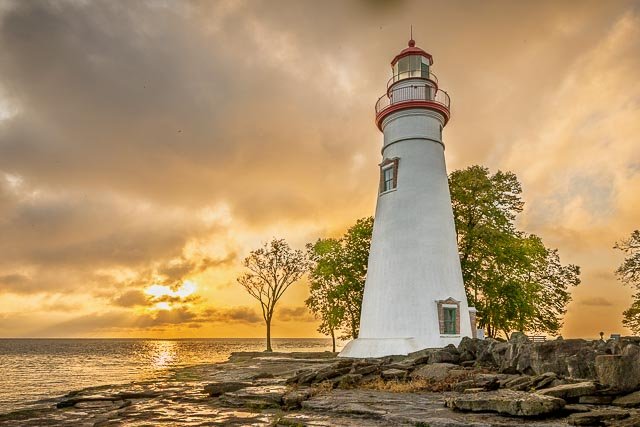
Marblehead Lighthouse The Marblehead Lighthouse is one of Lake Erie’s best known and most-photographed landmarks. It is the oldest lighthouse in continuous operation on the Great Lakes. Visitors can climb to the top of the lighthouse during the summer season for spectacular views of the lake and its islands in the distance. The lighthouse is now part of the 9-acre Marblehead Lighthouse State Park. The park features picnic tables and offers views of Lake Erie, Sandusky Bay, Kelleys Island, and South Bass Island. The Marblehead Lighthouse Historical Society operates the Marblehead Lighthouse Museum in the old keeper’s house. Exhibits include the lighthouse, a Fresnel lens, ice harvesting, ice fishing, the local maritime industry, ships, a replica Lifesaving Station, local fossils, and shipwrecks. Visitors can take tours of the lighthouse tower in the summer. The museum is open when tours are available. In 2016, a replica of the 1876 U.S. Lifesaving Station was built on the State Park property. The lifesaving station museum is located near the Lighthouse on the State Park Property and features a variety of exhibits and an authentically restored 27-foot Coast Guard rescue boat complete with a launching railway. Where it is: Marblehead Lighthouse is located in Marblehead Lighthouse State Park. From Highway 2 which crosses Sandusky Bay, go north on Highway 53 1.3 miles to Highway 163, then go east on Highway 163 just over eight miles to the eastern end of the peninsula. Turn north onto Lighthouse Drive and follow it to Marblehead Lighthouse State Park. Interactive Google Map Use the map  + – controls to zoom in and out, click and drag the to move the map, use the Map drop-down to change to “Map”, “Satellite”, “Hybrid”, or “Terrain” views.  Drag the little man icon from the upper left corner to a map location for street level view. Links: Marblehead Lighthouse State Park GPS: 41°32’10.02″ N 82°42’43.248″ W Hours: Park Hours: 6am to 11pm daily. Visitors are permitted to actively engage in legitimate recreational activities outside these hours. If you have questions, call the park office. Tours of the Lighthouse (Memorial Day Weekend through Labor Day) Noon-4pm every day in summer Cost: Tours $3 per person; children 5 & under free. Location Contact Information: Marblehead Lighthouse State Park 110 Lighthouse Dr Marblehead, OH 43440 Park Office: (419) 734-4424; Office located at East Harbor State Park Marblehead Lighthouse Photo Gallery Click Here for full page gallery     More Photographic Destinations in Ohio Interactive Google Map Use the map  + – controls to zoom in and out, use the Map drop-down to change to “Map”, “Satellite”, “Hybrid”, or “Terrain” views.  Drag the little man icon from the upper left corner to a map location for street level view. Click on a pushpin for more information about the Photographic Destination, then click on the title to go to the location page. Click Here for Photographic Destinations by State All the information in this post was believed to be accurate at the time it was published.  Please be sure to double check with the location before relying on this information as everything changes over time, especially hours, prices, and whether the location is still open.   Great Places for Great Photos   Let me help you to find a great location for your next photography adventure.  I will list many lesser-known destinations, as well as the famous "Icon Locations" for photography.  I will provide photos (Lots of Photos), location information, consisting of what there is to photograph as well as other information about the destination.  I will give costs, maps, directions, contact information, and other essential information for a successful photo trip.  I will only post for locations that I have personally photographed to ensure a quality guide to great locations for photography. If you know of great places that are not posted, please send me the details, I may just decide that is a place I need to go!     Greg Disch is a freelance photographer located in Arkansas. Greg specializes in nature, scenic, wildlife, and other outdoor subjects in Arkansas and other areas of the country.  Most of the images on this site are available for sale as prints, personal use, or rights managed stock photos. Greg offers both classroom instruction and in the field hands on photographic workshops. Classroom sessions are normally held in Fort Smith Arkansas, but arrangements can be made to bring a class to your group. All classes and workshops have small class sizes designed to provide an optimum student to instructor ratio, where you can get the personal attention, you need.  Most classes and workshops are limited to a maximum of six participants and will be held with a minimum of only two. If you are looking for a wonderful opportunity to get personal individual instruction, I do private workshops and classes at a location of your choice, whether doing a location photo shoot, coming to your home or business, traveling across the country on a road trip, or at my classroom.  This is a fantastic way to learn digital workflow and be sure that your computer equipment is properly configured for optimum performance. [...]Read more...
Lorain Harbor Lighthouse The Lorain West Breakwater Light, also called the Lorain Harbor Light, is a lighthouse in Lorain, Ohio, United States. The light was built in 1917 on Lake Erie by the United States Army Corps of Engineers. It was taken out of service in 1965 when it was replaced by an automated light tower on a nearby breakwater. The light was added to the National Register of Historic Places in 1978. The 1917 lighthouse was the fourth lighthouse built to service the City of Lorain’s Black River port. After the automated light tower was installed in 1965, the 1917 light was decommissioned and marked for demolition. The demolition had to be rescheduled for the following year after the project was delayed by a storm. During that time, the Lorain community was able to mobilize to save the lighthouse as a historical landmark for the City of Lorain. The original lens was a fourth order, Fresnel that was installed in 1918. When the lighthouse was decommissioned, the Fresnel lens was relocated for use in a New York lighthouse. In 2021 the original Lorain Fresnel lens was returned to Lorain and is on display inside the Lorain Port Authority. The Lorain Lighthouse has been managed by the Lorain Lighthouse Foundation (formerly Port of Lorain Foundation) since 1990. Where it is: From Highway 6 in Lorain just west of Black River, turn north onto Broadway and follow it to the piers where you will get a distant view of the light. There is a gap in the harbor breakwater, which prevents access to the lighthouse by foot. The walk to the end of the mile long pier begins at Erie Steak and Seafood Restaurant/Oasis Marina parking lot. From the West: Take OH-RT 6 east across the Charles Berry Bascule Bridge then turn left on Colorado Ave. Turn left onto Lakeside Ave and the very first right (almost immediate) is the Erie Steak and Seafood Restaurant/Oasis Marina parking lot. From the East: Take OH-RT 6 west until you come to Colorado Ave. Make a right on Colorado and then a left onto Lakeside Ave.and the very first right (almost immediate) is the Erie Steak and Seafood Restaurant/Oasis Marina parking lot. From the South: Take OH-RT 57 or OH-RT 58 north until you come to OH-RT 6. Turn right onto OH-RT 6. Take OH-RT 6 East across the Charles Berry Bascule Bridge then turn Left on Colorado Ave. Turn left onto Lakeside Ave and the very first right (almost immediate) is the Erie Steak and Seafood Restaurant/Oasis Marina parking lot. Links: https://lorainlighthouse.com/ GPS: 41°28’35.262″ N 82°10’51.09″ W  Lookout at end of pier. Hours: The pier is open to foot traffic all the time. Cost: There is no cost to view the lighthouse from the lookout on the mile long pier. Tours are available during the summer months by the Lorain Lighthouse Foundation.  Pricing starts at $25 per person. Location Contact Information: info@lorainlighthouse.com or mail at: Lorain Lighthouse Foundation c/o Lorain Port Authority 319 Black River Lane Lorain, OH 44052 Lorain Harbor Lighthouse Photo Gallery Click Here for full page gallery     More Photographic Destinations in Ohio Interactive Google Map Use the map  + – controls to zoom in and out, use the Map drop-down to change to “Map”, “Satellite”, “Hybrid”, or “Terrain” views.  Drag the little man icon from the upper left corner to a map location for street level view. Click on a pushpin for more information about the Photographic Destination, then click on the title to go to the location page. Click Here for Photographic Destinations by State All the information in this post was believed to be accurate at the time it was published.  Please be sure to double check with the location before relying on this information as everything changes over time, especially hours, prices, and whether the location is still open.   Great Places for Great Photos   Let me help you to find a great location for your next photography adventure.  I will list many lesser-known destinations, as well as the famous "Icon Locations" for photography.  I will provide photos (Lots of Photos), location information, consisting of what there is to photograph as well as other information about the destination.  I will give costs, maps, directions, contact information, and other essential information for a successful photo trip.  I will only post for locations that I have personally photographed to ensure a quality guide to great locations for photography. If you know of great places that are not posted, please send me the details, I may just decide that is a place I need to go!     Greg Disch is a freelance photographer located in Arkansas. Greg specializes in nature, scenic, wildlife, and other outdoor subjects in Arkansas and other areas of the country.  Most of the images on this site are available for sale as prints, personal use, or rights managed stock photos. Greg offers both classroom instruction and in the field hands on photographic workshops. Classroom sessions are normally held in Fort Smith Arkansas, but arrangements can be made to bring a class to your group. All classes and workshops have small class sizes designed to provide an optimum student to instructor ratio, where you can get the personal attention, you need.  Most classes and workshops are limited to a maximum of six participants and will be held with a minimum of only two. If you are looking for a wonderful opportunity to get personal individual instruction, I do private workshops and classes at a location of your choice, whether doing a location photo shoot, coming to your home or business, traveling across the country on a road trip, or at my classroom.  This is a fantastic way to learn digital workflow and be sure that your computer equipment is properly configured for optimum performance. [...]Read more...
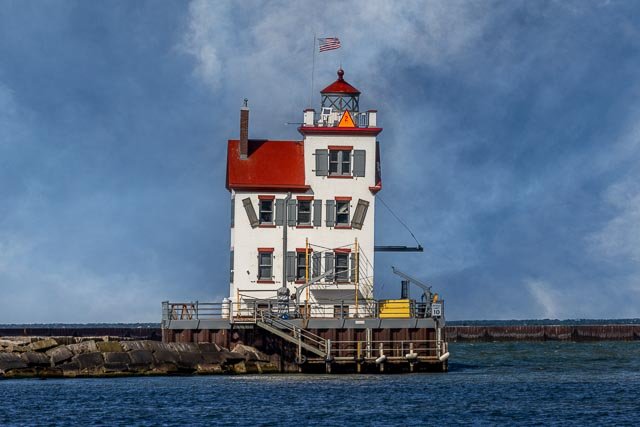
Huron Harbor Lighthouse Huron’s lighthouses have served as beacons to Great Lakes shipping since the early nineteenth century. The first of three Huron lighthouses was built in 1835. Built of wood and ill-equipped to deal with strong Lake Erie winds, it was destroyed by a fierce storm in May 1854. A second more secure lighthouse—fully enclosed and made of iron—was erected in 1857. The current white, pyramidal lighthouse was constructed in 1939 when the pier was extended to a location three-quarters of a mile offshore. It was one of the first Lake Erie lighthouses to provide an electrically powered beacon to aid maritime navigation. Its light can be seen over a twelve-mile radius. Where it is: Directions: From US-6 in Huron, Ohio, follow Williams Street north to the lake. It will end at Wall Street. Turn right onto Wall Street and follow that for a short distance to Main Street. Turn left onto Main Street, and follow that to the end where there is a small parking area. You can now walk out to the lighthouse on the pier. You can also view the lighthouse from the other side of the inlet. To get here you will follow Ohio Route 2 eastbound and get off at Ohio Route 13 and head towards the lake. Make a right onto Cleveland Road East (Ohio Route 6). You will go over several bridges, one over water and the next over railroad tracks. Make a left onto Tiffen and then a left onto Nickel Plate Drive. This will take you into Nickel Plate Park, a great place to view the light. Again this light sits out on a breakwater, I used a 500mm telephoto to get a nice close up shot. Maps: Interactive Google Map Use the map  + – controls to zoom in and out, click and drag the to move the map, use the Map drop-down to change to “Map”, “Satellite”, “Hybrid”, or “Terrain” views.  Drag the little man icon from the upper left corner to a map location for street level view. Cost: There is no cost to view the lighthouse. The lighthouse is owned by the Coast Guard. Grounds open, tower closed.  You are no longer allowed to walk all the way out to the lighthouse. Links: cityofhuron.org GPS: 41°24’7.05″ N 82°32’46.614″ W Hours: Hours: Dawn to Dusk The Huron Lighthouse is maintained by the United States Coast Guard. The mile long pier is open to the public and is a great fishing spot all year long. Location Contact Information: (419) 433-8487 Parks@huronohio.us 30 Main Street, end of N. Main Street, Huron, OH44839 Huron Harbor Lighthouse Photo Gallery Click Here for full page gallery     More Photographic Destinations in Ohio Interactive Google Map Use the map  + – controls to zoom in and out, use the Map drop-down to change to “Map”, “Satellite”, “Hybrid”, or “Terrain” views.  Drag the little man icon from the upper left corner to a map location for street level view. Click on a pushpin for more information about the Photographic Destination, then click on the title to go to the location page. Click Here for Photographic Destinations by State All the information in this post was believed to be accurate at the time it was published.  Please be sure to double check with the location before relying on this information as everything changes over time, especially hours, prices, and whether the location is still open.   Great Places for Great Photos   Let me help you to find a great location for your next photography adventure.  I will list many lesser-known destinations, as well as the famous "Icon Locations" for photography.  I will provide photos (Lots of Photos), location information, consisting of what there is to photograph as well as other information about the destination.  I will give costs, maps, directions, contact information, and other essential information for a successful photo trip.  I will only post for locations that I have personally photographed to ensure a quality guide to great locations for photography. If you know of great places that are not posted, please send me the details, I may just decide that is a place I need to go!     Greg Disch is a freelance photographer located in Arkansas. Greg specializes in nature, scenic, wildlife, and other outdoor subjects in Arkansas and other areas of the country.  Most of the images on this site are available for sale as prints, personal use, or rights managed stock photos. Greg offers both classroom instruction and in the field hands on photographic workshops. Classroom sessions are normally held in Fort Smith Arkansas, but arrangements can be made to bring a class to your group. All classes and workshops have small class sizes designed to provide an optimum student to instructor ratio, where you can get the personal attention, you need.  Most classes and workshops are limited to a maximum of six participants and will be held with a minimum of only two. If you are looking for a wonderful opportunity to get personal individual instruction, I do private workshops and classes at a location of your choice, whether doing a location photo shoot, coming to your home or business, traveling across the country on a road trip, or at my classroom.  This is a fantastic way to learn digital workflow and be sure that your computer equipment is properly configured for optimum performance. [...]Read more...
Fairport Harbor Lighthouse The Grand River (Fairport Harbor) Light is located in the village of Fairport Harbor, Ohio. The lighthouse was built in 1871 and has a 60-foot tower with a detached keeper’s house. The light was decommissioned in 1925, replaced by the Fairport Harbor West Breakwater Light. At one time the Coast Guard considered using the keeper’s house to house their personnel and demolish the tower but a letter writing campaign by local residents prevented it from happening. In 1945 the Coast Guard turned over ownership of the light to the town. The tower is open to the public and the keeper’s house currently serves as the Fairport Harbor Marine Museum and Lighthouse (the first of its kind in the country), operated by the Fairport Harbor Historical Society. Visitors can climb the lighthouse for a view of the harbor. Founded in 1945, the museum features exhibits about the history of the lighthouse and its keepers, a Fresnel lens, lifesaving equipment, life on the Great Lakes, ship models and maritime artifacts. There is a gift shop. The former pilothouse from the Great Lakes carrier the Frontenac is attached to the museum’s building. The museum is open seasonally, and is located at 129 Second Street. The lighthouse and museum are said to be haunted. Legend has it that a ghost cat haunts the facility. Volunteers and tourists alike have reported feeling a cat rub against them, although the cat is never seen. Where it is: The Grand River (Fairport Harbor) Light is located at the intersection of Second and High Streets in the village of Fairport Harbor. From Highway 2 in Fairport, take the Painesville Exit and go north on Richmond Street. Richmond Street will become High Street, and Fairport Lighthouse is on the corner of High Street and 2nd Street. Interactive Google Map Use the map  + – controls to zoom in and out, click and drag the to move the map, use the Map drop-down to change to “Map”, “Satellite”, “Hybrid”, or “Terrain” views.  Drag the little man icon from the upper left corner to a map location for street level view. Links: Fairport Harbor Marine Museum and Lighthouse GPS: 41°45’24.432″ N 81°16’38.64″ W Hours: Summer Hours for 2025 are Wednesdays, Fridays, Saturdays, Sundays and Legal Holidays – Noon – 6:00pm Cost: The cost is not clear on any information I could find, it appears to be between 4 and 7 dollars per person. Location Contact Information: Fairport Harbor Historical Society 129 Second Street Fairport Harbor, OH 44077 For more information call (440) 354-4825. email- keeper@fairportharborlighthouse.org Fairport Harbor Lighthouse Photo Gallery Click Here for full page gallery     More Photographic Destinations in Ohio Interactive Google Map Use the map  + – controls to zoom in and out, use the Map drop-down to change to “Map”, “Satellite”, “Hybrid”, or “Terrain” views.  Drag the little man icon from the upper left corner to a map location for street level view. Click on a pushpin for more information about the Photographic Destination, then click on the title to go to the location page. Click Here for Photographic Destinations by State All the information in this post was believed to be accurate at the time it was published.  Please be sure to double check with the location before relying on this information as everything changes over time, especially hours, prices, and whether the location is still open.   Great Places for Great Photos   Let me help you to find a great location for your next photography adventure.  I will list many lesser-known destinations, as well as the famous "Icon Locations" for photography.  I will provide photos (Lots of Photos), location information, consisting of what there is to photograph as well as other information about the destination.  I will give costs, maps, directions, contact information, and other essential information for a successful photo trip.  I will only post for locations that I have personally photographed to ensure a quality guide to great locations for photography. If you know of great places that are not posted, please send me the details, I may just decide that is a place I need to go!     Greg Disch is a freelance photographer located in Arkansas. Greg specializes in nature, scenic, wildlife, and other outdoor subjects in Arkansas and other areas of the country.  Most of the images on this site are available for sale as prints, personal use, or rights managed stock photos. Greg offers both classroom instruction and in the field hands on photographic workshops. Classroom sessions are normally held in Fort Smith Arkansas, but arrangements can be made to bring a class to your group. All classes and workshops have small class sizes designed to provide an optimum student to instructor ratio, where you can get the personal attention, you need.  Most classes and workshops are limited to a maximum of six participants and will be held with a minimum of only two. If you are looking for a wonderful opportunity to get personal individual instruction, I do private workshops and classes at a location of your choice, whether doing a location photo shoot, coming to your home or business, traveling across the country on a road trip, or at my classroom.  This is a fantastic way to learn digital workflow and be sure that your computer equipment is properly configured for optimum performance. [...]Read more...
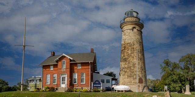
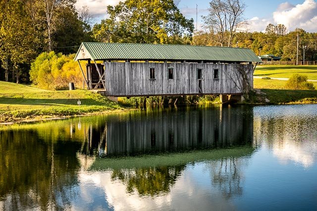
  Bay Covered Bridge BAY BRIDGE (1876) (Also called TINKER) Moved from its original site  over Little Raccoon Creek in 1967 (near Lake Rupert) to the Vinton County Junior Fairgrounds which is 1 1/2 miles north of McArthur on State Route 93. The move was precipitated by the construction of Lake Rupert. The bridge remains a unique attraction on the fairgrounds and is open to pedestrians. Where it is: Vinton County Junior Fairgrounds which is 1 1/2 miles north of McArthur on State Route 93. Maps: Interactive Google Map Use the map  + – controls to zoom in and out, click and drag the to move the map, use the Map drop-down to change to “Map”, “Satellite”, “Hybrid”, or “Terrain” views.  Drag the little man icon from the upper left corner to a map location for street level view. GPS: 39°16’10.71″ N 82°28’29.556″ W Cost: There is no cost to visit. Hours: Open when the fairgrounds are open, it is visible from State Route 93 North when the fairgrounds are closed. Facilities: There are facilities at the bridge which are part of the fairgrounds and only open during events. Location Contact Information: Vinton County Fairgrounds Map Unavailable Address 31471 St. Rt. 93 McArthur Ohio 45651 United States   Bay Covered Bridge Photo Gallery Click Here for full page gallery More Photographic Destinations in Ohio Interactive Google Map Use the map  + – controls to zoom in and out, use the Map drop-down to change to “Map”, “Satellite”, “Hybrid”, or “Terrain” views.  Drag the little man icon from the upper left corner to a map location for street level view. Click on a pushpin for more information about the Photographic Destination, then click on the title to go to the location page. Click Here for Photographic Destinations by State    All the information in this post was believed to be accurate at the time it was published.  Please be sure to double check with the location before relying on this information as everything changes over time, especially hours, prices, and whether the location is still open.   Great Places for Great Photos   Let me help you to find a great location for your next photography adventure.  I will list many lesser-known destinations, as well as the famous "Icon Locations" for photography.  I will provide photos (Lots of Photos), location information, consisting of what there is to photograph as well as other information about the destination.  I will give costs, maps, directions, contact information, and other essential information for a successful photo trip.  I will only post for locations that I have personally photographed to ensure a quality guide to great locations for photography. If you know of great places that are not posted, please send me the details, I may just decide that is a place I need to go!     Greg Disch is a freelance photographer located in Arkansas. Greg specializes in nature, scenic, wildlife, and other outdoor subjects in Arkansas and other areas of the country.  Most of the images on this site are available for sale as prints, personal use, or rights managed stock photos. Greg offers both classroom instruction and in the field hands on photographic workshops. Classroom sessions are normally held in Fort Smith Arkansas, but arrangements can be made to bring a class to your group. All classes and workshops have small class sizes designed to provide an optimum student to instructor ratio, where you can get the personal attention, you need.  Most classes and workshops are limited to a maximum of six participants and will be held with a minimum of only two. If you are looking for a wonderful opportunity to get personal individual instruction, I do private workshops and classes at a location of your choice, whether doing a location photo shoot, coming to your home or business, traveling across the country on a road trip, or at my classroom.  This is a fantastic way to learn digital workflow and be sure that your computer equipment is properly configured for optimum performance. [...]Read more...