Idaho Photographic Destinations

Craters of the Moon National Monument Shoshone Falls

Let me help you to find a great location in Idaho for your next photography adventure.  I will list many lesser known destinations, as well as the famous “Icon Locations” for photography.  I will provide photos (Lots of Photos), location information,  consisting of what there is to photograph as well as other information about the destination.  I will give costs, maps, directions, contact information, and other essential information for a successful photo trip.  I will only post for locations that I have personally photographed to insure a quality guide to great locations for photography in Idaho.

Interactive Google Map

Use the map  + – controls to zoom in and out, use the Map drop-down to change to “Map”, “Satellite”, “Hybrid”, or “Terrain” views.  Drag the little man icon from the upper left corner to a map location for street level view. Click on a pushpin for more information about the Photographic Destination, then click on the title to go to the location page.
 

Idaho Photographic Destinations

Idaho Destinations
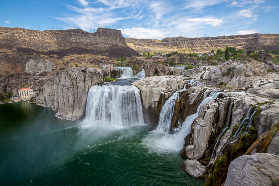
Shoshone Falls Shoshone Falls is a waterfall on the Snake River in southern Idaho, approximately 3 miles northeast of the city of Twin Falls. Sometimes called the “Niagara of the West,” Shoshone Falls is 212 feet high—45 feet higher than Niagara Falls—and flows over a rim nearly 1,000 feet wide. Formed by catastrophic outburst flooding during the Pleistocene ice age about 14,000 years ago, Shoshone Falls marks the historical upper limit of fish migration (including salmon) in the Snake River, and was an important fishing and trading place for Native Americans. The falls were documented by Europeans as early as the 1840s; despite the isolated location, it became a tourist attraction starting in the 1860s. At the beginning of the 20th century, part of the Snake River was diverted for irrigation of the Magic Valley. Now, the flows over the falls can be viewed seasonally based on snowfall, irrigation needs and hydroelectric demands. Irrigation and hydroelectric power stations built on the falls were the primary contributors to early economic development in southern Idaho. The City of Twin Falls owns and operates a park overlooking the waterfall.  The flow over the falls ranges from over 20,000 cubic feet per second during late spring of wet years, to a minimum “scenic flow” (dam release) of 300 cubic feet per second in dry years. What to Photograph: The spectacular waterfalls and the Snake River below. Best Time for Photographers: Shoshone Falls is best viewed in the spring, as diversion of the Snake River often significantly diminishes water levels in the late summer and fall. Where it is: Shoshone Falls is a waterfall on the Snake River in southern Idaho, United States, approximately 3 miles northeast of the city of Twin Falls. Shoshone Falls Falls Ave, 1 1/4 mile north on 3300 East Twin Falls, ID 83301 Maps: Interactive Google Map Use the map  + – controls to zoom in and out, click and drag the to move the map, use the Map drop-down to change to “Map”, “Satellite”, “Hybrid”, or “Terrain” views.  Drag the little man icon from the upper left corner to a map location for street level view.   Click here for larger map. GPS: 42°35’38.303″ N 114°24’6.173″ W Cost: The cost for admission at Shoshone Falls Park is $3.00 per car (subject to change). Parks and Recreation begins charging admission each year on March 30 and continues through September. Season passes to Shoshone Falls are $25 and are available to purchase at the Parks and Recreation Department building and the ticket booth at Shoshone Falls. Facilities: The falls offer a unique blend of recreational facilities, including playgrounds, hiking trails, picnic areas, a boat ramp, swimming area, and a scenic overlook. A picnic in the shaded, grassy areas provides a perfect vantage point for viewing Shoshone Falls. Amenities 11 grills Alcohol consumption prohibited on boat docks Boat launch to Snake River Concession stand Drinking fountain No electricity available Picnic tables Restrooms Shoshone Falls overlook Trails Links: City of Twin Falls Website Location Contact Information: Mailing Address P.O. Box 1907  |  Twin Falls, ID 83303 Physical Address 203 Main Ave. East  |  Twin Falls, ID 83301 Emergency 9-1-1 Non-Emergency (208) 735-4357 City Hall (208) 735-7287 Fax (208) 736-2296 Shoshone Falls Photo Gallery Click Here for full page gallery More Photographic Destinations in Idaho: Interactive Google Map Use the map  + – controls to zoom in and out, use the Map drop-down to change to “Map”, “Satellite”, “Hybrid”, or “Terrain” views.  Drag the little man icon from the upper left corner to a map location for street level view. Click on a pushpin for more information about the Photographic Destination, then click on the title to go to the location page. Click Here for Photographic Destinations by State    All the information in this post was believed to be accurate at the time it was published.  Please be sure to double check with the location before relying on this information as everything changes over time, especially hours, prices, and whether the location is still open.   Great Places for Great Photos   Let me help you to find a great location for your next photography adventure.  I will list many lesser-known destinations, as well as the famous "Icon Locations" for photography.  I will provide photos (Lots of Photos), location information, consisting of what there is to photograph as well as other information about the destination.  I will give costs, maps, directions, contact information, and other essential information for a successful photo trip.  I will only post for locations that I have personally photographed to ensure a quality guide to great locations for photography. If you know of great places that are not posted, please send me the details, I may just decide that is a place I need to go!     Greg Disch is a freelance photographer located in Arkansas. Greg specializes in nature, scenic, wildlife, and other outdoor subjects in Arkansas and other areas of the country.  Most of the images on this site are available for sale as prints, personal use, or rights managed stock photos. Greg offers both classroom instruction and in the field hands on photographic workshops. Classroom sessions are normally held in Fort Smith Arkansas, but arrangements can be made to bring a class to your group. All classes and workshops have small class sizes designed to provide an optimum student to instructor ratio, where you can get the personal attention, you need.  Most classes and workshops are limited to a maximum of six participants and will be held with a minimum of only two. If you are looking for a wonderful opportunity to get personal individual instruction, I do private workshops and classes at a location of your choice, whether doing a location photo shoot, coming to your home or business, traveling across the country on a road trip, or at my classroom.  This is a fantastic way to learn digital workflow and be sure that your computer equipment is properly configured for optimum performance. [...]Read more...
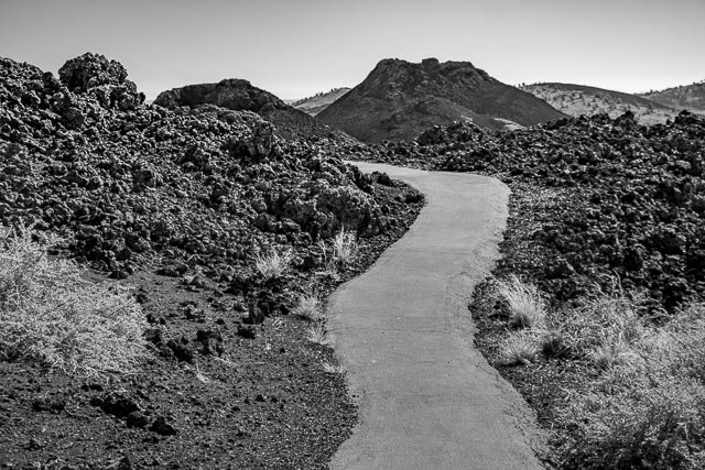
Craters of the Moon National Monument Craters of the Moon National Monument and Preserve is a U.S. national monument and national preserve in the Snake River Plain in central Idaho. The protected area’s features are volcanic and represent one of the best-preserved flood basalt areas in the continental United States. The Monument and Preserve encompass three major lava fields and about 400 square miles of sagebrush steppe grasslands to cover a total area of 1,117 square miles. The Monument alone covers 343,000 acres. All three lava fields lie along the Great Rift of Idaho, with some of the best examples of open rift cracks in the world, including the deepest known on Earth at 800 feet. There are excellent examples of almost every variety of basaltic lava, as well as tree molds (cavities left by lava-incinerated trees), lava tubes (a type of cave), and many other volcanic features. Where it is: Craters of the Moon is in south-central Idaho, midway between Boise and Yellowstone National Park. The lava field reaches southeastward from the Pioneer Mountains. Combined U.S. Highway 20–26–93 cuts through the northwestern part of the monument and provides access to it. However, the rugged landscape of the monument itself remains remote and undeveloped, with only one paved road across the northern end. Craters of the Moon’s visitor center is located 18 miles southwest of Arco, Idaho on U.S. Highway 20/26/93. It is 24 miles northeast of Carey, Idaho on U.S. Highway 20/26/93. The physical address is 1266 Craters Loop Road. Maps: Interactive Google Map Use the map  + – controls to zoom in and out, click and drag the to move the map, use the Map drop-down to change to “Map”, “Satellite”, “Hybrid”, or “Terrain” views.  Drag the little man icon from the upper left corner to a map location for street level view.   GPS: Latitude: 43° 27.711’N Longitude: 113° 33.791’W Cost: Standard Entrance Fees The following 7 day passes apply to private, non-commercial vehicles. The fee covers the driver and any passengers. Vehicle $20 Motorcycle $15 Walk in/ Bicycle $10 (15 and under free) National Park passes are accepted Whenever the Loop Road is not fully open to automobile travel, there is a Fee Free day! Depending on weather, this occurs roughly from November through April. Hours: The Monument and Preserve is open every day of the year, 24 hours a day. Winter snows usually prevent automobile access around the Loop Road from mid-November through mid-April. Visitor Center Hours Winter Hours (December through February): 9:00 a.m. to 4:30 p.m. daily Closed on the following federal winter holidays: Thanksgiving, Christmas Eve, Christmas Day, & New Years Day with an early closure on December 31 at 1:30 p.m Summer, Spring, and Fall Hours (March through November): 8:00 a.m. to 4:30 p.m. daily Facilities: There is no lodging available in the park. The nearest lodging and other services are available in Arco, 18 miles east of the visitor center. Aside from vending machines in the visitor center, there is no food service available in the park. Picnic tables are available on the east side of the visitor center and at various locations around the Loop Road. The nearest restaurants are located in the town of Arco. A campground with 42 sites are available on a first come-first served basis; no reservations are accepted. Location Contact Information: Craters of the Moon National Monument and Preserve National Park Service P.O. Box 29 Arco, ID 83213 Physical Address Craters of the Moon National Monument 1266 Craters Loop Road (18 miles west of Arco on U.S. Highway 20/26/93) By Phone Visitor Information (208) 527-1335 Headquarters (208) 527-1300 By Fax 208-527-3073 Craters of the Moon National Monument Photo Gallery Click Here for full page gallery   More Photographic Destinations in Idaho: Interactive Google Map Use the map  + – controls to zoom in and out, use the Map drop-down to change to “Map”, “Satellite”, “Hybrid”, or “Terrain” views.  Drag the little man icon from the upper left corner to a map location for street level view. Click on a pushpin for more information about the Photographic Destination, then click on the title to go to the location page. Click Here for Photographic Destinations by State    All the information in this post was believed to be accurate at the time it was published.  Please be sure to double check with the location before relying on this information as everything changes over time, especially hours, prices, and whether the location is still open.   Great Places for Great Photos   Let me help you to find a great location for your next photography adventure.  I will list many lesser-known destinations, as well as the famous "Icon Locations" for photography.  I will provide photos (Lots of Photos), location information, consisting of what there is to photograph as well as other information about the destination.  I will give costs, maps, directions, contact information, and other essential information for a successful photo trip.  I will only post for locations that I have personally photographed to ensure a quality guide to great locations for photography. If you know of great places that are not posted, please send me the details, I may just decide that is a place I need to go!     Greg Disch is a freelance photographer located in Arkansas. Greg specializes in nature, scenic, wildlife, and other outdoor subjects in Arkansas and other areas of the country.  Most of the images on this site are available for sale as prints, personal use, or rights managed stock photos. Greg offers both classroom instruction and in the field hands on photographic workshops. Classroom sessions are normally held in Fort Smith Arkansas, but arrangements can be made to bring a class to your group. All classes and workshops have small class sizes designed to provide an optimum student to instructor ratio, where you can get the personal attention, you need.  Most classes and workshops are limited to a maximum of six participants and will be held with a minimum of only two. If you are looking for a wonderful opportunity to get personal individual instruction, I do private workshops and classes at a location of your choice, whether doing a location photo shoot, coming to your home or business, traveling across the country on a road trip, or at my classroom.  This is a fantastic way to learn digital workflow and be sure that your computer equipment is properly configured for optimum performance. [...]Read more...