Great Places for Great Photos

Let me help you to find a great location for your next photography adventure. I will list many lesser known destinations, as well as the famous “Icon Locations” for photography. I will provide photos (Lots of Photos), location information, consisting of what there is to photograph as well as other information about the destination. I will give costs, maps, directions, contact information, and other essential information for a successful photo trip. I will only post for locations that I have personally photographed to insure a quality guide to great locations for photography.

Route 66 Destinations

Interactive Google Map

Use the map  + – controls to zoom in and out, use the Map drop-down to change to “Map”, “Satellite”, “Hybrid”, or “Terrain” views.  Drag the little man icon from the upper left corner to a map location for street level view. Click on a pushpin for more information about the Photographic Destination, then click on the title to go to the location page.
Route 66

Route 66 Destinations
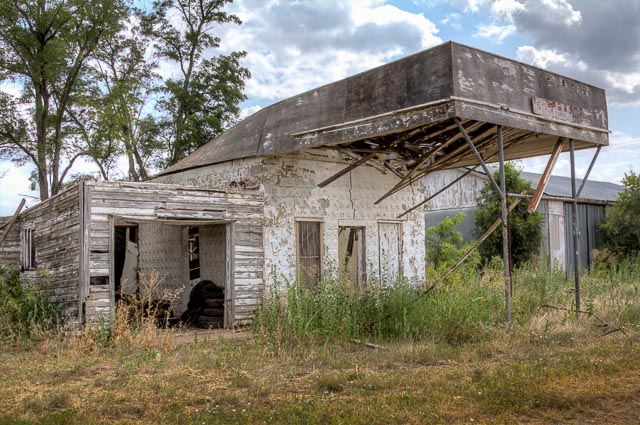
  Texola Ghost Town Texola is a living Ghost Town meaning there are still people living there even though the town is mostly abandoned.  Texola sits on the border of Texas and Oklahoma on old Route 66.  There are many abandoned buildings including a 1930 Magnolia Gas Station and a one room jail. The History of Texola dates back to the early 1900s. Before being named Texola, the town site had been called Texokla and Texoma. Because of its location near the 100th Meridian, the town was surveyed eight different times, which meant that some early residents lived in both Texas and Oklahoma without ever moving. Texola was originally part of northern Greer County until Beckham County was formed after Oklahoma gained statehood in 1907. A post office was established in the community on December 12, 1901 with Reuben H. Grimes serving as the first postmaster. In 1902, the Choctaw, Oklahoma and Gulf Railroad (later owned by the Chicago, Rock Island and Pacific Railway) was built through the town. A weekly newspaper, the Texola Herald, began publishing in 1902 and continued to operate into the early 1920s. By 1909, Texola had two cotton gins as well as a corn and grist mill. The local economy was agriculturally based and several businesses opened in the community. The 1910 census recorded 361 people living in Texola. That same year, a small Territorial Jail was built. After a slight decline in population during the 1910s, Texola grew rapidly in the 1920s. The population peaked at 581 in the 1930 census. The arrival of Route 66  had a positive impact on the local economy. Cotton production increased during the decade, necessitating the need for two additional gins. As the town prospered, amenities such as a ten-acre park and an auditorium capable of seating 300 people were found in the community. The population began to decline in the 1940s and continued to do so throughout the remainder of the twentieth century. By 1980, Texola was a town of 106 residents. When the next census was conducted in 1990, Texola had lost nearly 58 percent of its population, leaving just 45 people in the town. That figure rose by two, to 47, in 2000. By 2010, the population had decreased to 36.     One Room Jail The Texola Territorial Jail was used from 1908 to 1910 and consists of nothing more than a one room block building with iron bars on the door and window. the walls continue several feet underground to keep the bad guys from digging out.   Where it is: Texola is located on Route 66 just south of Interstate 40 Oklahoma Exit 1. Get directions on Google Maps Maps: Interactive Google Map Use the map  + – controls to zoom in and out, click and drag the to move the map, use the Map drop-down to change to “Map”, “Satellite”, “Hybrid”, or “Terrain” views.  Drag the little man icon from the upper left corner to a map location for street level view. GPS: 35°13’9.312″ N 99°59’29.232″ W Cost: There is no cost to visit Texola. Hours: The location is accessible at all times. Facilities: There are no public facilities available. Location Contact Information: No contact information is available.     Texola Ghost Town Photo Gallery Click Here for full page gallery   More Photographic Destinations in Oklahoma Interactive Google Map Use the map  + – controls to zoom in and out, use the Map drop-down to change to “Map”, “Satellite”, “Hybrid”, or “Terrain” views.  Drag the little man icon from the upper left corner to a map location for street level view. Click on a pushpin for more information about the Photographic Destination, then click on the title to go to the location page. Click Here for Photographic Destinations by State    All the information in this post was believed to be accurate at the time it was published.  Please be sure to double check with the location before relying on this information as everything changes over time, especially hours, prices, and whether the location is still open.   Great Places for Great Photos   Let me help you to find a great location for your next photography adventure.  I will list many lesser-known destinations, as well as the famous "Icon Locations" for photography.  I will provide photos (Lots of Photos), location information, consisting of what there is to photograph as well as other information about the destination.  I will give costs, maps, directions, contact information, and other essential information for a successful photo trip.  I will only post for locations that I have personally photographed to ensure a quality guide to great locations for photography. If you know of great places that are not posted, please send me the details, I may just decide that is a place I need to go!     Greg Disch is a freelance photographer located in Arkansas. Greg specializes in nature, scenic, wildlife, and other outdoor subjects in Arkansas and other areas of the country.  Most of the images on this site are available for sale as prints, personal use, or rights managed stock photos. Greg offers both classroom instruction and in the field hands on photographic workshops. Classroom sessions are normally held in Fort Smith Arkansas, but arrangements can be made to bring a class to your group. All classes and workshops have small class sizes designed to provide an optimum student to instructor ratio, where you can get the personal attention, you need.  Most classes and workshops are limited to a maximum of six participants and will be held with a minimum of only two. If you are looking for a wonderful opportunity to get personal individual instruction, I do private workshops and classes at a location of your choice, whether doing a location photo shoot, coming to your home or business, traveling across the country on a road trip, or at my classroom.  This is a fantastic way to learn digital workflow and be sure that your computer equipment is properly configured for optimum performance. [...]Read more...
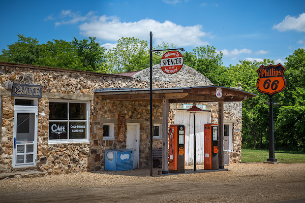
Spencer Ghost Town Spencer is a small unincorporated crossroads in eastern Lawrence County, Missouri, United States. It lies along former U.S. Route 66 (now a county road) approximately six miles  west of Halltown.  A post office called Spencer was established in 1868, and remained in operation until 1907. The community was named after a local merchant whose store was known as “Spencer”. Prior to that the place was known as Johnson’s Mill. Route 66 is many things to many people. Each person tends to experience the road differently There is a certain spirit / feeling, that resides along Route 66. The spirit Of Route 66 lives on in people. their stories, the structures that they have seen, and their appreciation Spencer. Missouri is a very important part of the historical Route 66. Route 66 bypassed Spencer in 1961. The story behind Spencer was one man’s dream. Sidney Casey heard that the first major east to west highway (U S Route 66) would be constructed through the center of the United States. He had the vision to know that some day when the road came through, it would be an excellent location to operate the many business’s that he eventually had, such as, service station garage, cafe, grocery store, barber shop. post Office and feed store (all but the cafe and barber shop were operated by the Casey family). He wanted this dream so bad that he walked 100 miles on foot to buy the property in July 1925. He contacted the owner of this property, Frank Johnson, and paid him S400.00 for the entire asking price, for the store building and two acres of land. And eventually after many years his dream had been fulfilled. This land was also important because across the road there was a labor camp. They  had several hundred men that were used to construct the highway. They used the water from Johnson Creek and mixed their concrete by hand in sleds and used teams of horses to pull the sleds to the roadway and hand troweled the concrete. As of today, the highway in front of Spencer is the only one of four stretches of Route 66 that has the original concrete road and has never been overlaid or widened. In its heyday, Spencer was an important stop along Route 66. There were tourist cabins up the hill at Camp Lookout, that you could rent nightly and a wooden dance floor that was a popular attraction to the many travelers passing through on Route 66. Francis and Mary Lynn Ryan purchased Spencer in 2007. They have done a lot of research to help them in their goal to restore the Buildings back to how they were. Over the years, many structures along Missouri ‘s Route 66 have deteriorated and it’s sad to see history disappear. The Ryans purchased Spencer with intention of keeping it from deteriorating any further. There is too much at stake. It is not just a service station or feed store or café, it is a town. Restoring it has been a huge undertaking, but has received great recognition in Missouri. So much could be done with this particular strip of Route 66, but their interests at this time is to preserve the structures of the town of Spencer. Their plans are not to make any of the stores functional, but to restore them to look like they did back in the 30 ‘s and 40 ‘s. Lots of work and money has gone into the restoration but the Ryan ‘s have enjoyed every part of it. In the short time they have owned Spencer, the Ryan Is have been overwhelmed with the tourists that stop and just want to know about the history of Spencer and what their future plans are. Where it is: Spencer is located on historic Route 66 six miles west of Halltown Mo.  From Route 66 turn south onto Co Rd 2062 (the original Route 66) and drive one mile to the gas station, on the left. Maps: Interactive Google Map Use the map  + – controls to zoom in and out, click and drag the to move the map, use the Map drop-down to change to “Map”, “Satellite”, “Hybrid”, or “Terrain” views.  Drag the little man icon from the upper left corner to a map location for street level view.   GPS: 37°11’4.283″ N 93°42’10.181″ W   Cost: There is no cost to visit Spencer, this is private property, please show respect. Hours: There are no hours, if the owners are present they may have the buildings open and will tell you the history of the town.   Location Contact Information: Address: Co Rd 2062, Spencer, MO No contact information is available. Facilities: There are no facilities in Spencer.   Spencer Ghost Town  Photo Gallery Click Here for full page gallery   More Photographic Destinations in Missouri: Interactive Google Map Use the map  + – controls to zoom in and out, use the Map drop-down to change to “Map”, “Satellite”, “Hybrid”, or “Terrain” views.  Drag the little man icon from the upper left corner to a map location for street level view. Click on a pushpin for more information about the Photographic Destination, then click on the title to go to the location page. Click Here for Photographic Destinations by State    All the information in this post was believed to be accurate at the time it was published.  Please be sure to double check with the location before relying on this information as everything changes over time, especially hours, prices, and whether the location is still open.   Great Places for Great Photos   Let me help you to find a great location for your next photography adventure.  I will list many lesser-known destinations, as well as the famous "Icon Locations" for photography.  I will provide photos (Lots of Photos), location information, consisting of what there is to photograph as well as other information about the destination.  I will give costs, maps, directions, contact information, and other essential information for a successful photo trip.  I will only post for locations that I have personally photographed to ensure a quality guide to great locations for photography. If you know of great places that are not posted, please send me the details, I may just decide that is a place I need to go!     Greg Disch is a freelance photographer located in Arkansas. Greg specializes in nature, scenic, wildlife, and other outdoor subjects in Arkansas and other areas of the country.  Most of the images on this site are available for sale as prints, personal use, or rights managed stock photos. Greg offers both classroom instruction and in the field hands on photographic workshops. Classroom sessions are normally held in Fort Smith Arkansas, but arrangements can be made to bring a class to your group. All classes and workshops have small class sizes designed to provide an optimum student to instructor ratio, where you can get the personal attention, you need.  Most classes and workshops are limited to a maximum of six participants and will be held with a minimum of only two. If you are looking for a wonderful opportunity to get personal individual instruction, I do private workshops and classes at a location of your choice, whether doing a location photo shoot, coming to your home or business, traveling across the country on a road trip, or at my classroom.  This is a fantastic way to learn digital workflow and be sure that your computer equipment is properly configured for optimum performance. [...]Read more...
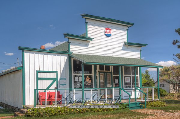
  Soulsby Service Station Rt 66 The Soulsby Service Station is a historic service station in Mount Olive, Illinois. The station is located along historic U.S. Route 66 and is the oldest usable service station on the highway in Illinois. The Soulsby Station is an excellent example of a house with canopy form.  By the time Mr. Soulsby built his station in 1926, the leading oil companies had been hiring architects to design stations that would blend well with neighborhoods to minimize local opposition to the crudeness often associated with gas stations. Mr. Soulsby designed the building himself, taking into account these trends and blending well with the surrounding area. Although the Great Depression soon began, the station thrived.  America was broke, but it was still traveling. As Will Rogers would say, “We might be the first nation to drive to the poorhouse in an automobile.” When Henry Soulsby retired, his children Russell and Ola Soulsby took over the station, a partnership that would endure until Ola’s death in 1996.  Each was as adept as the other at pumping gas, checking the oil, and looking under the hood or chassis to detect and fix problems. Russell always had an eye for technology.  During World War II, he was a communications technician in the Pacific theater. Shortly after coming home, he turned his experience into a second, simultaneous career–radio and television repair. He used an antenna on the roof of the station to test his work. Route 66 was a great agent of progress and development, but its very success helped spell its doom. In the late 1950s, Interstate 55 began supplanting it in Illinois. In Mount Olive, the Soulsby Station ended up a mile away from the new thoroughfare. In 1991, the Soulsby Station stopped pumping gas but continued to check oil, sell soda pop, and greet the ever-growing legion of Route 66 tourists. Sending everyone off with a wink and a wave, Russell and Ola closed the doors for good in 1993 and sold the station in 1997 to a neighbor, Mike Dragovich. When Russell Soulsby died in 1999, his funeral procession took him under the canopy one last time. This time it was his friends’ turn to wink and wave. The current owner, Mr. Dragovich, and the Soulsby Preservation Society began preservation efforts in 2003, removing vinyl siding, restoring the original doors and windows, and repainting the exterior. In 2004, the National Park Service provided grant support for restoration efforts. Today, the station looks essentially the same as it did during its post-World War II heyday. It was listed in the National Register of Historic Places in 2004. Where it is: The Soulsby Service Station is located on old Route 66 in Mount Olive Illinois. 710 W 1st S St, Mt Olive, IL 62069 Maps: Interactive Google Map Use the map  + – controls to zoom in and out, click and drag the to move the map, use the Map drop-down to change to “Map”, “Satellite”, “Hybrid”, or “Terrain” views.  Drag the little man icon from the upper left corner to a map location for street level view.   GPS: 39°4’15.9728″ N 89°44’7.0658″ W   Cost: There is no cost to visit. Hours: There are no regular hours for the location, the grounds are open 24 hours a day.   Facilities: There are no facilities at the service station, however there are restaurants and other stores in Mt. Olive. Location Contact Information: 710 W. First St. Mt. Olive IL 62069 Phone: +1 800-258-6645 Soulsby Service Station Photo Gallery Click Here for full page gallery   More Photographic Destinations in Illinois Interactive Google Map Use the map  + – controls to zoom in and out, use the Map drop-down to change to “Map”, “Satellite”, “Hybrid”, or “Terrain” views.  Drag the little man icon from the upper left corner to a map location for street level view. Click on a pushpin for more information about the Photographic Destination, then click on the title to go to the location page. Click Here for Photographic Destinations by State    All the information in this post was believed to be accurate at the time it was published.  Please be sure to double check with the location before relying on this information as everything changes over time, especially hours, prices, and whether the location is still open.   Great Places for Great Photos   Let me help you to find a great location for your next photography adventure.  I will list many lesser-known destinations, as well as the famous "Icon Locations" for photography.  I will provide photos (Lots of Photos), location information, consisting of what there is to photograph as well as other information about the destination.  I will give costs, maps, directions, contact information, and other essential information for a successful photo trip.  I will only post for locations that I have personally photographed to ensure a quality guide to great locations for photography. If you know of great places that are not posted, please send me the details, I may just decide that is a place I need to go!     Greg Disch is a freelance photographer located in Arkansas. Greg specializes in nature, scenic, wildlife, and other outdoor subjects in Arkansas and other areas of the country.  Most of the images on this site are available for sale as prints, personal use, or rights managed stock photos. Greg offers both classroom instruction and in the field hands on photographic workshops. Classroom sessions are normally held in Fort Smith Arkansas, but arrangements can be made to bring a class to your group. All classes and workshops have small class sizes designed to provide an optimum student to instructor ratio, where you can get the personal attention, you need.  Most classes and workshops are limited to a maximum of six participants and will be held with a minimum of only two. If you are looking for a wonderful opportunity to get personal individual instruction, I do private workshops and classes at a location of your choice, whether doing a location photo shoot, coming to your home or business, traveling across the country on a road trip, or at my classroom.  This is a fantastic way to learn digital workflow and be sure that your computer equipment is properly configured for optimum performance. [...]Read more...
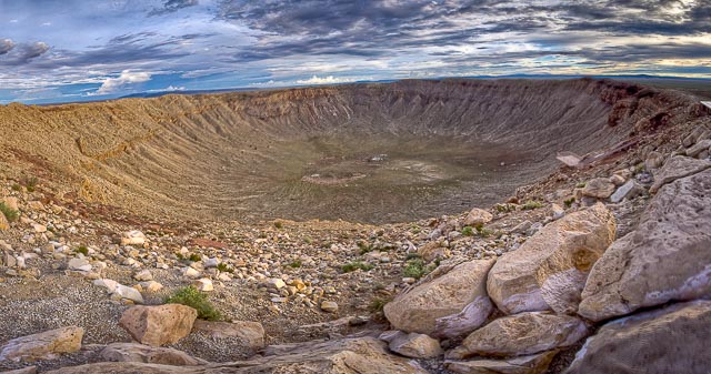
Red Oak II Red Oak II is the creation of artist Lowell Davis, who’s family had pioneered the town of Red Oak. After success as an artist, he started moving his old home town to his farm 32 miles away creating Red Oak II. Lowell now lives in what he considers his “Masterpiece” in the Belle Starr house where the famous outlaw was raised. Red Oak II is located a few miles Northeast of Carthage Missouri, just off Route 66. Red Oak II, a faithful reproduction of a small Missouri town, is the labor of love of one Lowell Davis. In the late 1980s, he began creating Red Oak II in an empty field not far from Carthage. Davis grew up in the nearby town of Red Oak, and like many of us, witnessed and lamented some of the changes taking place in countless small communities in the boom years following the end of World War II. So, he turned his artistic talents to the issue. Davis began procuring castoff buildings, moving them here, and sprucing them up. What you’ll see is nearly a complete town, minus the people and traffic you’d see if all of the buildings were inhabited and in use. You’ll find a general store, blacksmith shop, service station, church, residences (some of which are now occupied), and much more. There’s even a cemetery to complete the picture. Admission & Hours Red Oak II does not have regular hours and is always open, and there is no admission charge, however Lowell does accept donations to help with the upkeep.  Please keep in mind that this is private property and people live here, please respect their privacy and obey signs. What to Photograph: The list of items to photograph is very long and includes many old original buildings from the town of Red Oak, and the surrounding area including Route 66. Some of the buildings include: Elmira School Red Oak II Cafe School Marm House Trolly Car Diner Feed and Seed Store Town Hall Bandstand Log Barn Blacksmith Shop General Store Woodshed Phillips 66 Gas Station Belle Star House The Birdsong Salem Country Church Marshall Hooker Cabin Marshall’s Office In addition are many other structures and homes, lots of antique cars, and some of Lowell’s whimsical art work. Best Time for Photographers: Anytime is a good time here, there is enough variety and different angles to be able to shoot all day long. Getting There: Driving Directions Take Hwy 96 east out of Carthage MO for 1 mile, you will see a lake on the right and Flyin’ W Convenience Store on the left.  You will then see an old car on a post on the left side of the road, turn left here on Rd 130 and follow the signs to Red Oak II. Maps: Interactive Google Map Use the map  + – controls to zoom in and out, click and drag the to move the map, use the Map drop-down to change to “Map”, “Satellite”, “Hybrid”, or “Terrain” views.  Drag the little man icon from the upper left corner to a map location for street level view. Location Contact Information: Red Oak II County Loop 122, Kafir Rd Carthage, Missouri 64836 (417) 237-0808 lowelldavis@redoakii.com Links Red Oak II Website Red Oak II Facebook Page Lowell Davis Artist Nearest City or Town:  Carthage MO Red Oak II Photo Gallery Click Here for full page gallery More Photographic Destinations in Missouri: Interactive Google Map Use the map  + – controls to zoom in and out, use the Map drop-down to change to “Map”, “Satellite”, “Hybrid”, or “Terrain” views.  Drag the little man icon from the upper left corner to a map location for street level view. Click on a pushpin for more information about the Photographic Destination, then click on the title to go to the location page. Click Here for Photographic Destinations by State    All the information in this post was believed to be accurate at the time it was published.  Please be sure to double check with the location before relying on this information as everything changes over time, especially hours, prices, and whether the location is still open.   Great Places for Great Photos   Let me help you to find a great location for your next photography adventure.  I will list many lesser-known destinations, as well as the famous "Icon Locations" for photography.  I will provide photos (Lots of Photos), location information, consisting of what there is to photograph as well as other information about the destination.  I will give costs, maps, directions, contact information, and other essential information for a successful photo trip.  I will only post for locations that I have personally photographed to ensure a quality guide to great locations for photography. If you know of great places that are not posted, please send me the details, I may just decide that is a place I need to go!     Greg Disch is a freelance photographer located in Arkansas. Greg specializes in nature, scenic, wildlife, and other outdoor subjects in Arkansas and other areas of the country.  Most of the images on this site are available for sale as prints, personal use, or rights managed stock photos. Greg offers both classroom instruction and in the field hands on photographic workshops. Classroom sessions are normally held in Fort Smith Arkansas, but arrangements can be made to bring a class to your group. All classes and workshops have small class sizes designed to provide an optimum student to instructor ratio, where you can get the personal attention, you need.  Most classes and workshops are limited to a maximum of six participants and will be held with a minimum of only two. If you are looking for a wonderful opportunity to get personal individual instruction, I do private workshops and classes at a location of your choice, whether doing a location photo shoot, coming to your home or business, traveling across the country on a road trip, or at my classroom.  This is a fantastic way to learn digital workflow and be sure that your computer equipment is properly configured for optimum performance. [...]Read more...
  Meteor Crater Fifty thousand year ago, a giant fireball streaked across the North American sky. It struck the Earth in what is now northern Arizona, exploding with the force of 2 1/2 million tons of TNT, or about 150 times the force of the atomic bomb that destroyed Hiroshima.  The meteorite weighed 300,000 tons and traveled at a speed of 26,000 miles per hour. Most of the meteorite was melted by the force of the impact, and spread across the landscape in a very fine, nearly atomized mist of molten metal. Millions of tons of limestone and sandstone were blasted out of the crater, covering the ground for a mile in every direction with a blanket of shattered, pulverized and partially melted rock mixed with fragments of meteoritic iron. When the dust settled, what remained was a crater three-quarters of a mile (about 1 kilometer) wide and 750 feet deep. The impact occurred during the last ice age, a time when the Arizona landscape was cooler and wetter than it is today. The plain around it was covered with a forest, where mammoths, mastodons and giant ground sloths grazed. The force of the impact would have leveled the forest for miles around, hurling the mammoths across the plain and killing or severely injuring any animals unfortunate enough to be nearby. Over time, the landscape recovered. A lake formed in the bottom of the crater, and sediments accumulated until the bowl was only 550 feet deep. Then, with the ending of the ice age, the climate changed and dried. The desert that we see today has helped to preserve the crater, by limiting the erosion that might otherwise have blurred or erased the traces of the ancient impact. Meteor Crater Observatory In the mid-1930′s, Harry and Hope Locke built the impressive Meteor Crater Observatory on Route 66 near the Meteor Crater in Arizona, west of Winslow. It was soon closed down due to lack of visitors, and a huge debt incurred during construction. However, in 1946 Dr. Harvey Nininger re-opened the observatory as the American Meteorite Museum -dedicated to the study of meteorites. Dr. Nininger worked and lived in the observatory for many years. Visitors could pay 25 cents to peer through the telescope in the observatory tower at the huge meteor crater 6 miles to the south. Today, only ruins remain. Where it is: Barringer Crater or Meteor Crater is a natural landmark near US Route 66 (just 5.8 miles south of I-40’s Exit 233) 18 miles west of Winslow Arizona and 37 miles east of Flagstaff Arizona. Get directions on Google Maps Maps: Interactive Google Map Use the map  + – controls to zoom in and out, click and drag the to move the map, use the Map drop-down to change to “Map”, “Satellite”, “Hybrid”, or “Terrain” views.  Drag the little man icon from the upper left corner to a map location for street level view.   GPS: 35°1’57.3437″ N 111°1’15.574″ W Cost: GENERAL ADMISSION RATES ON-SITE WEBSITE Adults (age 13 to 59) $22 $20 Seniors (age 60 & older) $20 $18 Juniors (age 6 to 12) $13 $11 Non-Active Duty U.S. Military/Veterans (with I.D.) $13 $11 Active Duty U.S. Military FREE FREE Hours: OPEN DAILY 8:00 AM – 5:00 PM Open until 12PM on Thanksgiving Day & Closed Christmas Day Facilities: The site has restrooms, a gift shop, and a sandwich shop onsite. Location Contact Information: METEOR CRATER Interstate 40, Exit 233 Winslow, AZ 86047 USA PHONE (928) 289-5898 EMAIL info@meteorcrater.com Meteor Crater Photo Gallery Click Here for full page gallery   More Photographic Destinations in Arizona Interactive Google Map Use the map  + – controls to zoom in and out, use the Map drop-down to change to “Map”, “Satellite”, “Hybrid”, or “Terrain” views.  Drag the little man icon from the upper left corner to a map location for street level view. Click on a pushpin for more information about the Photographic Destination, then click on the title to go to the location page. Click Here for Photographic Destinations by State    All the information in this post was believed to be accurate at the time it was published.  Please be sure to double check with the location before relying on this information as everything changes over time, especially hours, prices, and whether the location is still open.   Great Places for Great Photos   Let me help you to find a great location for your next photography adventure.  I will list many lesser-known destinations, as well as the famous "Icon Locations" for photography.  I will provide photos (Lots of Photos), location information, consisting of what there is to photograph as well as other information about the destination.  I will give costs, maps, directions, contact information, and other essential information for a successful photo trip.  I will only post for locations that I have personally photographed to ensure a quality guide to great locations for photography. If you know of great places that are not posted, please send me the details, I may just decide that is a place I need to go!     Greg Disch is a freelance photographer located in Arkansas. Greg specializes in nature, scenic, wildlife, and other outdoor subjects in Arkansas and other areas of the country.  Most of the images on this site are available for sale as prints, personal use, or rights managed stock photos. Greg offers both classroom instruction and in the field hands on photographic workshops. Classroom sessions are normally held in Fort Smith Arkansas, but arrangements can be made to bring a class to your group. All classes and workshops have small class sizes designed to provide an optimum student to instructor ratio, where you can get the personal attention, you need.  Most classes and workshops are limited to a maximum of six participants and will be held with a minimum of only two. If you are looking for a wonderful opportunity to get personal individual instruction, I do private workshops and classes at a location of your choice, whether doing a location photo shoot, coming to your home or business, traveling across the country on a road trip, or at my classroom.  This is a fantastic way to learn digital workflow and be sure that your computer equipment is properly configured for optimum performance. [...]Read more...
Glenrio Ghost Town During the 1940s and 1950s, Glenrio sat very much alone in the open scrub desert of the high plains straddling the Texas-New Mexico border. Amarillo was 73 miles to the east and Tucumcari 41 miles west. Travelers driving Route 66 across the desert could see a world of stars at night, with Glenrio providing some of the only light pollution around with its diners, bars, western-themed motels, a dance hall, and gas stations. Glenrio was a flash of neon in the desert, an overnight Mecca, and a spot of evening cool in the days before cars had air conditioning. Straddling the State line, Glenrio began as Rock Island Railroad stop. Although part of the town was located in Texas and the other part in New Mexico, the Federal Government considered Glenrio to be a Texas town during those days. Mail would be dropped off on the Texas side of the border and then the station master would carry the mailbag to the post office on the New Mexico side for delivery. Glenrio was not a railroad town for long. In 1913, the Ozark Trails Association organized and began marking and promoting hundreds of miles of highways connecting several States, including New Mexico and Texas. Ozark Trails pioneered the transition from horse-drawn buggies and wagons to automobiles along America’s roads. By 1917, the Glenrio Hotel began receiving guests traveling by automobile along the Ozark Trail. At that point, trail was a good description of the Ozark. The crooked, dirt track was dusty in the sun and muddy in the rain. It had square turns as it followed section lines. Yet motorists came. By 1919, green and white Ozark Trail markers stood along the route through Glenrio. The Ozark Trail was incorporated into the United States highway system as part of Route 66 in 1926. By that year, Glenrio had essentially turned its back on the railroad in favor of the highway. Businesses near the railroad either closed or moved to be closer to the highway. Several gas stations, a restaurant, and at least one motel were built on the northern right of way of Route 66 by the early 1930s. On the south side of the highway, a welcome station on the Texas side offered assistance–including water to cool overheated radiators–to motorists along the road. Local lore has it that the welcome station served as a film location for the 1940 movie, The Grapes of Wrath. This cannot be confirmed, but if location scouts didn’t choose Glenrio as a set, one has to wonder why. Even today, it’s not hard to imagine heavily loaded cars full of families leaving the Dust Bowl behind to seek a better life in California, their hopes pinned to Route 66. During the 1930s, Route 66 was transformed into a continuous two-lane paved highway across Texas. Several gas stations, a new restaurant, and a motel clustered along the north side of the road. A few buildings from Glenrio’s rail-town past were moved close to the new highway, but most were demolished or fell into ruin. There were no bars on the Texas side of the community, since Deaf Smith County was dry, and no service stations on the New Mexico side because of that state’s higher gasoline tax. During the 1940s, 50s, and 60s, travelers packed the highway and Glenrio thrived. Former resident John Paul Ferguson worked summers at Glenrio gas stations. He recalls constant traffic during the daytime, with cars lined up five or six in a row waiting to get gas. A new cluster of businesses were built during the 1950s. Two of them, a Texaco Gas Station and a nearby diner, are of particular interest today. Both were designed with Art Moderne influence. Look for the curved vertical panels on top of the drive-thru bay of the station and for curved concrete corner walls and a curved metal canopy on the diner. Both of these buildings are well preserved. Glenrio’s boom times ended in 1975 when Interstate 40 bypassed the town. It was listed in the National Register of Historic Places in 2007. Today, the Glenrio Historic District includes the old Route 66 roadbed and 17 abandoned buildings. Most of the buildings are utilitarian with concrete foundations, stucco walls, and flat roofs, but several of the buildings are distinctive. You can still identify the Little Juarez Diner, the State Line Bar, and the State Line Motel whose sign reads “Motel, Last in Texas” to travelers arriving from the east, and “Motel, First in Texas” to traffic motoring into town from the west. Only two Glenrio buildings are occupied–the Joseph Brownlee House and an office in the Texas Longhorn Motel. Other buildings have overgrown sites, missing windows, or debris surrounding them, the detritus of four decades when Glenrio welcomed tens of thousands, fed and entertained them, and sent the on their way toward Chicago or California. It’s well worth the detour to get off Interstate 40 and cruise Route 66 through Glenrio. Crossing the State border in one of the country’s best preserved mid-century ghost towns evokes some of the adventure motorists from decades ago felt when the traveled long stretches of two-lane blacktop through the American West. Portions of The Grapes of Wrath (1940) were filmed in Glenrio. An abandoned “Glenn Rio Motel” is depicted in the town of Radiator Springs in 2006’s animated film Cars, where the architectural design of Glenrio’s Little Juarez Café is used for a vacant, abandoned building, which eventually becomes the Racing Museum. The opening scene from the movie Daylight’s End (2018) was filmed in Glenrio. Where it is: Glenrio sits just a few yards to the south of Interstate 40 at Texas exit 0 on Business I-40, a road which turns into a local gravel road at the state line. This was the original Route 66 alignment between Glenrio and San Jon until 1952, and was paved for many years until Quay County removed the paving due to maintenance costs. Maps: Interactive Google Map Use the map  + – controls to zoom in and out, click and drag the to move the map, use the Map drop-down to change to “Map”, “Satellite”, “Hybrid”, or “Terrain” views.  Drag the little man icon from the upper left corner to a map location for street level view.   GPS: 35°10’43.266″ N 103°2’36.876″ W Cost: There is no cost to visit Glenrio. Hours: There are no hours, the location is accessable 24 hour per day. Facilities: There are no facilities in Glenrio, there is a visitor center and rest area on the New Mexico westbound lane of Interstate 40. Glenrio Ghost Town Photo Gallery Click Here for full page gallery   More Photographic Destinations in Texas: Interactive Google Map Use the map  + – controls to zoom in and out, use the Map drop-down to change to “Map”, “Satellite”, “Hybrid”, or “Terrain” views.  Drag the little man icon from the upper left corner to a map location for street level view. Click on a pushpin for more information about the Photographic Destination, then click on the title to go to the location page. Click Here for Photographic Destinations by State    All the information in this post was believed to be accurate at the time it was published.  Please be sure to double check with the location before relying on this information as everything changes over time, especially hours, prices, and whether the location is still open.   Great Places for Great Photos   Let me help you to find a great location for your next photography adventure.  I will list many lesser-known destinations, as well as the famous "Icon Locations" for photography.  I will provide photos (Lots of Photos), location information, consisting of what there is to photograph as well as other information about the destination.  I will give costs, maps, directions, contact information, and other essential information for a successful photo trip.  I will only post for locations that I have personally photographed to ensure a quality guide to great locations for photography. If you know of great places that are not posted, please send me the details, I may just decide that is a place I need to go!     Greg Disch is a freelance photographer located in Arkansas. Greg specializes in nature, scenic, wildlife, and other outdoor subjects in Arkansas and other areas of the country.  Most of the images on this site are available for sale as prints, personal use, or rights managed stock photos. Greg offers both classroom instruction and in the field hands on photographic workshops. Classroom sessions are normally held in Fort Smith Arkansas, but arrangements can be made to bring a class to your group. All classes and workshops have small class sizes designed to provide an optimum student to instructor ratio, where you can get the personal attention, you need.  Most classes and workshops are limited to a maximum of six participants and will be held with a minimum of only two. If you are looking for a wonderful opportunity to get personal individual instruction, I do private workshops and classes at a location of your choice, whether doing a location photo shoot, coming to your home or business, traveling across the country on a road trip, or at my classroom.  This is a fantastic way to learn digital workflow and be sure that your computer equipment is properly configured for optimum performance. [...]Read more...
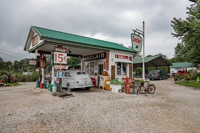
Gay Parita Sinclair – Paris Springs Junction The Gay Parita Service Station is located on Route 66 in the now Ghost Town of Paris Springs Junction. Gay and Fred Mason built the cobblestone garage in the 1920’s, which was followed by a Sinclair Gas Station, and then the Gay Parita store and restaurant across the street. The station burned down in 1955 and shortly after Route 66 was realigned and bypassed Paris Springs. The property was purchased by Gary Turner who rebuilt the gas station recreating a 1930 gas station, except that it did not sell gas or anything else for that matter. Gary spent his days welcoming visitors on Route 66 until his death in 2015. Gary’s Daughter Barbara has taken over the station and still greeting visitors. What to Photograph The restored gas station, old cars and trucks and more route 66 memorabilia than you can imagine. Where it is: located 25 miles west of Springfield, MO on Historic Route 66. (3 miles west of Halltown on Old 66) Directions: I-44 westbound exit 57 onto Hwy 96 (If eastbound, take exit 58 and double-back to exit 57). Drive west two miles on Hwy 96. Turn right onto Hwy 266, then quickly turn left to continue driving west (This is old, unmarked Route 66). Drive a half-mile. You’ll see the gas station on the right. Maps: Interactive Google Map Use the map  + – controls to zoom in and out, click and drag the to move the map, use the Map drop-down to change to “Map”, “Satellite”, “Hybrid”, or “Terrain” views.  Drag the little man icon from the upper left corner to a map location for street level view.   GPS: 37°11’39.972″ N 93°40’45.576″ W Hours: There are no established hours, however they are open most days, when they are closed the gate is locked. Cost: There is no cost to visit, donations are accepted. Location Contact Information:  Contact 21118 Old 66, Ash Grove, MO 65604-7107 Contact information * we will respond with in 24hr * 1-843-324-6661 1-417-459-0798 smilest@swbell.net   Gay Parita Sinclair – Paris Springs Junction Photo Gallery Click Here for full page gallery   More Photographic Destinations in Missouri: Interactive Google Map Use the map  + – controls to zoom in and out, use the Map drop-down to change to “Map”, “Satellite”, “Hybrid”, or “Terrain” views.  Drag the little man icon from the upper left corner to a map location for street level view. Click on a pushpin for more information about the Photographic Destination, then click on the title to go to the location page. Click Here for Photographic Destinations by State    All the information in this post was believed to be accurate at the time it was published.  Please be sure to double check with the location before relying on this information as everything changes over time, especially hours, prices, and whether the location is still open.   Great Places for Great Photos   Let me help you to find a great location for your next photography adventure.  I will list many lesser-known destinations, as well as the famous "Icon Locations" for photography.  I will provide photos (Lots of Photos), location information, consisting of what there is to photograph as well as other information about the destination.  I will give costs, maps, directions, contact information, and other essential information for a successful photo trip.  I will only post for locations that I have personally photographed to ensure a quality guide to great locations for photography. If you know of great places that are not posted, please send me the details, I may just decide that is a place I need to go!     Greg Disch is a freelance photographer located in Arkansas. Greg specializes in nature, scenic, wildlife, and other outdoor subjects in Arkansas and other areas of the country.  Most of the images on this site are available for sale as prints, personal use, or rights managed stock photos. Greg offers both classroom instruction and in the field hands on photographic workshops. Classroom sessions are normally held in Fort Smith Arkansas, but arrangements can be made to bring a class to your group. All classes and workshops have small class sizes designed to provide an optimum student to instructor ratio, where you can get the personal attention, you need.  Most classes and workshops are limited to a maximum of six participants and will be held with a minimum of only two. If you are looking for a wonderful opportunity to get personal individual instruction, I do private workshops and classes at a location of your choice, whether doing a location photo shoot, coming to your home or business, traveling across the country on a road trip, or at my classroom.  This is a fantastic way to learn digital workflow and be sure that your computer equipment is properly configured for optimum performance. [...]Read more...
  Elmer Long’s Bottle Tree Ranch Elmer Long’s Bottle Tree Ranch is a landmark on Route 66 located near Oro Grande California in the Mojave Desert.  Elmer grew up in California and accompanied his father on trips to the desert where they collected  most anything they could find, including bottles for his fathers collection.   Elmer built his first bottletree in 2000 and when his father passed away a few years later Elmer inherited his fathers collection .  The bottletrees continued to a count of over 200 with all of the other junk making each one unique. Elmer Long passed away peacefully on June 22nd, 2019 surrounded by friends and family. He created an amazing place that became a thing of wonder and a destination for people all over the world. His family will do everything in it’s power to preserve and protect his legacy after his sudden passing. Where it is: Elmer Long’s Bottle Tree Ranch is located at 24266 National Trails Hwy, Oro Grande, CA 92368, between Victorville & Barstow on what used to be Route 66. Maps: Interactive Google Map Use the map  + – controls to zoom in and out, click and drag the to move the map, use the Map drop-down to change to “Map”, “Satellite”, “Hybrid”, or “Terrain” views.  Drag the little man icon from the upper left corner to a map location for street level view. GPS: 34.6903, -117.3394 Cost: There is no cost to visit, but donations are greatly appreciated Hours: There are not set hours but is open most days and can be seen and photographed from outside the fence when the gate is closed. Facilities: There are no facilities at the location. Location Contact Information: 24266 National Trails Hwy Oro Grande, California, 92368 United States info@thebottletreeranch.com   Elmer Long’s Bottle Tree Ranch Photo Gallery Click Here for full page gallery   More Photographic Destinations in California Interactive Google Map Use the map  + – controls to zoom in and out, use the Map drop-down to change to “Map”, “Satellite”, “Hybrid”, or “Terrain” views.  Drag the little man icon from the upper left corner to a map location for street level view. Click on a pushpin for more information about the Photographic Destination, then click on the title to go to the location page. Click Here for Photographic Destinations by State    All the information in this post was believed to be accurate at the time it was published.  Please be sure to double check with the location before relying on this information as everything changes over time, especially hours, prices, and whether the location is still open.   Great Places for Great Photos   Let me help you to find a great location for your next photography adventure.  I will list many lesser-known destinations, as well as the famous "Icon Locations" for photography.  I will provide photos (Lots of Photos), location information, consisting of what there is to photograph as well as other information about the destination.  I will give costs, maps, directions, contact information, and other essential information for a successful photo trip.  I will only post for locations that I have personally photographed to ensure a quality guide to great locations for photography. If you know of great places that are not posted, please send me the details, I may just decide that is a place I need to go!     Greg Disch is a freelance photographer located in Arkansas. Greg specializes in nature, scenic, wildlife, and other outdoor subjects in Arkansas and other areas of the country.  Most of the images on this site are available for sale as prints, personal use, or rights managed stock photos. Greg offers both classroom instruction and in the field hands on photographic workshops. Classroom sessions are normally held in Fort Smith Arkansas, but arrangements can be made to bring a class to your group. All classes and workshops have small class sizes designed to provide an optimum student to instructor ratio, where you can get the personal attention, you need.  Most classes and workshops are limited to a maximum of six participants and will be held with a minimum of only two. If you are looking for a wonderful opportunity to get personal individual instruction, I do private workshops and classes at a location of your choice, whether doing a location photo shoot, coming to your home or business, traveling across the country on a road trip, or at my classroom.  This is a fantastic way to learn digital workflow and be sure that your computer equipment is properly configured for optimum performance. [...]Read more...
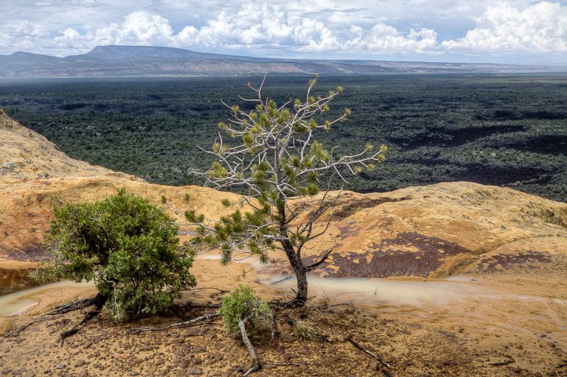
El Malpais National Monument Description: Sandstone Bluffs overlooks millions of years of geologic history, from the 200-million year-old sandstone formed by ancient seas, to the 3000 year-old lava that borders the bluffs. From here, however, you see more than just rocks; you see a land that is part of the cultural history of the many people who have lived, and who continue to live alongside this land of volcanoes and sandstone. After rainfalls, the potholes, or tinajas, fill with water and create temporary miniature ecosystems. Fairy shrimp, tadpole shrimp, spadefoot toad tadpoles and water insects find homes in these tiny oases. Look for these small animals after summer rains fill the shallow depressions. The tinajas atop of the bluffs undoubtedly supplied people with water as well. Cost: There are no fees charged at El Malpais National Monument and Conservation Area for regular visitation.All overnight and backcountry use requires a free permit. Some caves require a Special Use Permit. Educational groups need to make reservations for ranger-led activities. Best Time to Visit: Sandstone Bluffs is open from sunrise to sunset, and can be visited during anytime of the year. Where it is: El Malpais is located near Grants New Mexico and 72 miles from Albuquerque New Mexico. Directions: Interstate 40 is the main east-west highway into the region. Exit 89, east of Grants, will take you along NM 117 which forms the eastern boundary. BLM’s El Malpais Ranger Station is located 9 miles south of this exit and is open daily from 8:30 am until 4:30 pm. Map: Click here to view National Park Service  map Links: National Park Service Web SiteSandstone Bluffs Brochure Contact Information: El Malpais National Monument 123 East Roosevelt Avenue Grants, NM 87020 505 783-4774 Weather: El Malpais is located at elevations that range from 6,500 to over 8,000 feet above sea level in a semi-desert. Precipitation averages 10 inches annually with most of it coming from rainfall during the monsoon season (July-September). Thunderstorms are a common occurrence during the summer months and lightning poses a hazard to hikers. Summer temperatures range from 80-100 degrees during the day with nighttime temperatures between 40-60 degrees. Winter temperatures range from 30-50 degrees in the day and can dip below zero at night. History: The area has had volcanic activity dating from 115,000 years ago to as recent as 3000 years ago.  Puebloan Indians have lived in the area for 10,000 years and continue their ancestral uses, including gathering herbs and medicines and other ceremonial activities.El Malpais National Monument is new to the National Park System, having been established in 1987, it contains 114,277 acres.  El Malpais translates to “the badlands” in Spanish and is pronounced Mal-(rhymes with wall)-pie-ees. Tips for the Photographer Equipment:You will want to bring everything that you have and then borrow some of your friends equipment. You will then need to bring a packmule to carry all of the things you will want for this photo location. What to Photograph: From the Sandstone Bluffs you can see the lava flow in the valley below, which runs for nearly 40 miles.  The bluffs themselves are a great subject with ever changing forms.  The tinajas, or potholes fill with water after a rain and make great subjects.Vegetation varies from low shrubs with a piñon and juniper to ponderosa pine woodlands. Wildflower displays occur mainly in the fall after the summer monsoons, with a modest spring cactus & wildflower display. Wildlife includes a variety of mammals, birds, reptiles, and amphibians. In warmer weather, rattlesnakes are sometimes sighted in the canyons or heard under rocks, so please be alert. Photography Tips: There are many opportunities for photos on the bluffs, from wide angle panoramic  to close up macro shots of life in the tinajas.  When shooting into water be sure to use a polarizing filter to remove the reflections from the surface so you can see into the water.To capture the true perspective of the valley try doing a panorama.  To properly shoot for a panorama be sure to set your camera to manual mode so the exposures do not change from one shot to the next.  Then take a series of shots overlapping by about 25%.  Combine the photos using Photoshop or other panorama stitching software.  With current software, use of a tripod is not necessary but will always help steady your camera and compose the shot.There are no trails and you are free to explore, but be careful there are no rails with steep drop-off and cliffs. After rainfalls, the potholes, or tinajas, fill with water and create temporary miniature ecosystems. Fairy shrimp, tadpole shrimp, spadefoot toad tadpoles and water insects find homes in these tiny oases. Look for these small animals after summer rains fill the shallow depressions. The tinajas atop of the bluffs undoubtedly supplied people with water as well. More Photographic Destinations in New Mexico: Interactive Google Map Use the map  + – controls to zoom in and out, use the Map drop-down to change to “Map”, “Satellite”, “Hybrid”, or “Terrain” views.  Drag the little man icon from the upper left corner to a map location for street level view. Click on a pushpin for more information about the Photographic Destination, then click on the title to go to the location page. Click Here for Photographic Destinations by State   All the information in this post was believed to be accurate at the time it was published.  Please be sure to double check with the location before relying on this information as everything changes over time, especially hours, prices, and whether the location is still open.   Great Places for Great Photos   Let me help you to find a great location for your next photography adventure.  I will list many lesser-known destinations, as well as the famous "Icon Locations" for photography.  I will provide photos (Lots of Photos), location information, consisting of what there is to photograph as well as other information about the destination.  I will give costs, maps, directions, contact information, and other essential information for a successful photo trip.  I will only post for locations that I have personally photographed to ensure a quality guide to great locations for photography. If you know of great places that are not posted, please send me the details, I may just decide that is a place I need to go!     Greg Disch is a freelance photographer located in Arkansas. Greg specializes in nature, scenic, wildlife, and other outdoor subjects in Arkansas and other areas of the country.  Most of the images on this site are available for sale as prints, personal use, or rights managed stock photos. Greg offers both classroom instruction and in the field hands on photographic workshops. Classroom sessions are normally held in Fort Smith Arkansas, but arrangements can be made to bring a class to your group. All classes and workshops have small class sizes designed to provide an optimum student to instructor ratio, where you can get the personal attention, you need.  Most classes and workshops are limited to a maximum of six participants and will be held with a minimum of only two. If you are looking for a wonderful opportunity to get personal individual instruction, I do private workshops and classes at a location of your choice, whether doing a location photo shoot, coming to your home or business, traveling across the country on a road trip, or at my classroom.  This is a fantastic way to learn digital workflow and be sure that your computer equipment is properly configured for optimum performance. [...]Read more...
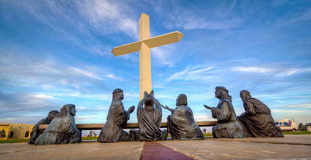
Cross of our Lord Jesus Christ Description: Groom Texas is the site of the the largest free standing cross in the western hemisphere, located along interstate 40 in Groom Texas.  The cross was erected in 1995, and is 19 stories, or 190 feet tall.  The giant cross can be seen from as far as 25 miles away and seen by millions of motorists every year.  Around the base of the cross are life size sculptors depiction the 12 stations of the cross. Cost: This Cross is given for everyone and is open 24/7. There is no charge to visit or spend the night. Best Time to Visit: Anytime would be good, but sunrise or sunset will give the best photos.  Gift Shop Summer hours — 8:30 a.m. to 8:30 p.m. — Winter hours — 9:00 a.m. to 5:30 p.m. Where it is: The cross is located 40 miles east of Amarillo Texas on Interstate highway 40, and is visible from the road. Directions: Exit off I40 at  exit 112 Ranch Rd. 295 to county Rd. 2, or simply exit and drive to the cross, you can’t miss it. Map: Interactive Google Map Use the map  + – controls to zoom in and out, click and drag the to move the map, use the Map drop-down to change to “Map”, “Satellite”, “Hybrid”, or “Terrain” views.  Drag the little man icon from the upper left corner to a map location for street level view. Links: Cross of our Lord Jesus Christ Ministries Tips for the Photographer Equipment: You can photograph with any camera, and there is plenty of room to back off as far as needed to capture the entire cross, however a wide angle lens would make it easier. What to Photograph: The 19 story high cross is the primary subject, but there are many other sculptures to photograph including the twelve life size stations of the cross and the last supper. Photography Tips: When photographing architectural subjects such as the cross it is important to try and keep the vertical lines straight, watch closely in your view finder that the cross is not appearing to fall over sideways.Unless you are photographing on an overcast day, or in the golden hour, you will be dealing with harsh contrasting light.  Photographing the dark sculptures against a light sky you will need to over expose to maintain the detail and try to shoot with the sun at your back to avoid a silhouette effect. Cross of our Lord Jesus Christ Photo Gallery Click Here for full page gallery More Photographic Destinations in Texas: Interactive Google Map Use the map  + – controls to zoom in and out, use the Map drop-down to change to “Map”, “Satellite”, “Hybrid”, or “Terrain” views.  Drag the little man icon from the upper left corner to a map location for street level view. Click on a pushpin for more information about the Photographic Destination, then click on the title to go to the location page. Click Here for Photographic Destinations by State All the information in this post was believed to be accurate at the time it was published.  Please be sure to double check with the location before relying on this information as everything changes over time, especially hours, prices, and whether the location is still open.   Great Places for Great Photos   Let me help you to find a great location for your next photography adventure.  I will list many lesser-known destinations, as well as the famous "Icon Locations" for photography.  I will provide photos (Lots of Photos), location information, consisting of what there is to photograph as well as other information about the destination.  I will give costs, maps, directions, contact information, and other essential information for a successful photo trip.  I will only post for locations that I have personally photographed to ensure a quality guide to great locations for photography. If you know of great places that are not posted, please send me the details, I may just decide that is a place I need to go!     Greg Disch is a freelance photographer located in Arkansas. Greg specializes in nature, scenic, wildlife, and other outdoor subjects in Arkansas and other areas of the country.  Most of the images on this site are available for sale as prints, personal use, or rights managed stock photos. Greg offers both classroom instruction and in the field hands on photographic workshops. Classroom sessions are normally held in Fort Smith Arkansas, but arrangements can be made to bring a class to your group. All classes and workshops have small class sizes designed to provide an optimum student to instructor ratio, where you can get the personal attention, you need.  Most classes and workshops are limited to a maximum of six participants and will be held with a minimum of only two. If you are looking for a wonderful opportunity to get personal individual instruction, I do private workshops and classes at a location of your choice, whether doing a location photo shoot, coming to your home or business, traveling across the country on a road trip, or at my classroom.  This is a fantastic way to learn digital workflow and be sure that your computer equipment is properly configured for optimum performance. [...]Read more...
Cadillac Ranch Cadillac Ranch is a public art installation and sculpture in Amarillo, Texas, U.S. It was created in 1974 by Chip Lord, Hudson Marquez and Doug Michels, who were a part of the art group Ant Farm, and it consists of what were (when originally installed during 1974) either older running used or junk Cadillac automobiles, representing a number of evolutions of the car line (most notably the birth and death of the defining feature of early Cadillacs; the tail fin) from 1949 to 1963, half-buried nose-first in the ground, at an angle corresponding to that of the Great Pyramid of Giza in Egypt. It was originally located in a wheat field, but in 1997 the installation was quietly moved by a local contractor two  to the west, to a cow pasture along Interstate 40, in order to place it further from the limits of the growing city. Cadillac Ranch is visible from the highway, and though it is located on private land, visiting it (by driving along a frontage road and entering the pasture by walking through an unlocked gate) is tacitly encouraged. In addition, writing graffiti on or otherwise spray-painting the vehicles is also encouraged, and the vehicles, which have long since lost their original colors, are wildly decorated. The cars are periodically repainted various colors (once white for the filming of a television commercial, another time pink in honor of Stanley’s wife Wendy’s birthday , and yet another time all 10 cars were painted flat black to mark the passing of Ant Farm artist Doug Michels or simply to provide a fresh canvas for future visitors. The cars were briefly “restored” to their original colors by the motel chain Hampton Inn in a public relation sponsored series of Route 66 landmark restoration projects. The new paint jobs and even the plaque commemorating the project lasted less than 24 hours without fresh graffiti. Cost: There is no fee for visiting Cadillac Ranch Best Time to Visit: The area is open 24 hours a day seven days a week, but there are no lights so plan to visit during daylight hours or furnishing your own lighting. Where it is: In a cow pasture outside of Amarillo TX Directions: Along eastbound I-40 between exits 60 and 62. Exit buy generic viagra in the usa onto the frontage road, a remnant of historic Route 66, then enter the pasture through an unlocked gate. Map: Links: Official Cadillac Ranch Website Amarillo Convention & Visitor Council Tips for the Photographer Equipment: You do not need any special equipment for this location, anything from a point and shoot up will give good results. What to Photograph: Cadillac Ranch is famous for the 10 Cadillacs buried in the ground in a cow pasture in in the Texas panhandle, don’t expect anything more than that.  The cars have been painted so many time the spray paint has built up to be over an inch thick in places, with changing colors and patterns.  You could photograph this site every week and it would look different. Photography Tips: Trying to shoot all 10 Cadillacs at one time will not give a real interesting shot.  Move in close and shoot the detail and color of the cars for some really interesting and abstract photos. Cadillac Ranch Photo Gallery Click Here for full page gallery More Photographic Destinations in Texas: Interactive Google Map Use the map  + – controls to zoom in and out, use the Map drop-down to change to “Map”, “Satellite”, “Hybrid”, or “Terrain” views.  Drag the little man icon from the upper left corner to a map location for street level view. Click on a pushpin for more information about the Photographic Destination, then click on the title to go to the location page. Click Here for Photographic Destinations by State All the information in this post was believed to be accurate at the time it was published.  Please be sure to double check with the location before relying on this information as everything changes over time, especially hours, prices, and whether the location is still open.   Great Places for Great Photos   Let me help you to find a great location for your next photography adventure.  I will list many lesser-known destinations, as well as the famous "Icon Locations" for photography.  I will provide photos (Lots of Photos), location information, consisting of what there is to photograph as well as other information about the destination.  I will give costs, maps, directions, contact information, and other essential information for a successful photo trip.  I will only post for locations that I have personally photographed to ensure a quality guide to great locations for photography. If you know of great places that are not posted, please send me the details, I may just decide that is a place I need to go!     Greg Disch is a freelance photographer located in Arkansas. Greg specializes in nature, scenic, wildlife, and other outdoor subjects in Arkansas and other areas of the country.  Most of the images on this site are available for sale as prints, personal use, or rights managed stock photos. Greg offers both classroom instruction and in the field hands on photographic workshops. Classroom sessions are normally held in Fort Smith Arkansas, but arrangements can be made to bring a class to your group. All classes and workshops have small class sizes designed to provide an optimum student to instructor ratio, where you can get the personal attention, you need.  Most classes and workshops are limited to a maximum of six participants and will be held with a minimum of only two. If you are looking for a wonderful opportunity to get personal individual instruction, I do private workshops and classes at a location of your choice, whether doing a location photo shoot, coming to your home or business, traveling across the country on a road trip, or at my classroom.  This is a fantastic way to learn digital workflow and be sure that your computer equipment is properly configured for optimum performance. [...]Read more...