
Cumberland Island National Seashore

Cumberland Island National Seashore preserves most of Cumberland Island in Camden County, Georgia, the largest of Georgia’s Golden Isles. The seashore features beaches and dunes, marshes, and freshwater lakes. The national seashore also preserves and interprets many historic sites and structures.
Instrumental in the creation and preservation of the seashore were several conservation organizations including the Sierra Club and the Georgia Conservancy.
The island is only accessible by boat. The Cumberland Island Visitor Center, Cumberland Island Museum, and Lang concession ferry to the island are located in the town of St. Marys, Georgia. Public access via the ferry is limited, reservations are recommended. Camping is allowed in the seashore. The 9,886-acre Cumberland Island Wilderness is part of the seashore.
The national seashore was authorized by Congress on October 23, 1972, and is administered by the National Park Service. The wilderness area was designated on September 8, 1982. It includes the High Point-Half Moon Bluff Historic District, which was listed on the National Register of Historic Places in 1978.
The Dungeness and Plum Orchard were designated as National Historic Districts in 1982 and 1984 respectively. The Dungeness district contains the ruins of the Carnegie Dungeness mansion and its supporting structures and gardens, the Tabby House dating to the Early Republic, and a cemetery. The Plum Orchard Historic District contains the intact Plum Orchard mansion dating to the 1890s, a shell midden dating back over 4,000 years, and the mansion’ support structures including an electrical house.
What to Photograph
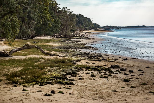
Beach
Cumberland Island is home to 17 miles of uninterrupted beach. No docks, houses, or other structures interrupt its serene beauty. The island boasts a healthy expanse of vegetated dunes that make it one of the most important nesting spots for loggerhead sea turtles in all of Georgia, and a sanctuary for migrating shore birds.
Cumberland Island National Seashore.
Dungeness Ruins

Visit the ruins of a mansion that was once called Dungeness. First built in 1884, the Dungeness Mansion was intended as a winter home for Thomas Carnegie (younger brother and business partner of Andrew Carnegie), his wife Lucy, and their 9 children. Though Thomas passed away soon after construction, Lucy Carnegie went on to spend more and more time and resources on the island estate. Several additions and remodels were made over the next thirty years. By the time Lucy passed in 1916 the mansion had grown to approximately 35,000 square feet. The mansion caught fire in 1959 and only the brick and stone walls remain.
Though the mansion is in ruins it still remains one of the most picturesque and visited spots on the island. Visitors can walk the grounds around the house and the numerous support buildings that were part of operating the estate.
Guided walking tours are offered when staffing permits
Plum Orchard Mansion
Construction of the mansion began in 1898, as a wedding gift for George Lauder Carnegie and Margaret Thaw. The architecture firm Peabody & Stearns was employed to design the original home, as well as the additions that were made over the next two decades. The house served as the couple’s primary winter residence until George’s passing in 1921.
Visitors can take a free tour of the 22,000 square foot mansion. On display are the architecture, furnishings, and machinery that made operation of the house possible. Plum Orchard offers a glimpse into Edwardian High Society at the turn of the 20th century and the importance of recreation, indulgence, and rejuvenation in nature. But further exploration tells the story of a family who valued the island, and their time spent with friends and family there.
Located 7 miles North of the Sea Camp dock (14 miles roundtrip). Due to the distance, day visitors should plan accordingly. No drinking water in route.
Estimated roundtrip time:
- for biking, 3 – 5 hours.
- for hiking, 8 – 10 hours (not recommended for day visitors).
The First African Baptist Church
This humble, one room church was established in 1893 by African American residents of the island and their families. Some of the founders were born into slavery and emancipated following the American Civil War. The church served as a free place of worship and community center for the Northend community known as the Settlement. The church was rebuilt in the 1930’s. It was the site of the September 1996 wedding of John F. Kennedy, Jr. and Carolyn Bessette.
Located 14 miles North of the Sea Camp dock. Due to the distance, day visitors should not attempt to visit the church unless taking part in the Lands & Legacies Tour. The doors are open. This facility is not staffed.
Where it is:
Cumberland Island is located six miles east of St. Marys, Georgia.
The only way to get to the island is by passenger ferry (not a car ferry) or private boat. For information about making a reservation with the National Park Service official concessionaire operated ferry visit our Reservations page or visit Cumberland Island Ferry website.
Private boats can dock – 7 days a week – on the north end of Sea Camp and Dungeness docks, except as marked. All of Plum Orchard dock is open and usable. Space is limited and all docking is first come, first serve. There is no overnight docking.
Driving Directions
Take Exit 3 from Interstate 95. At the exit stop light turn east on to Highway 40. Follow the signs traveling east into Historic St. Marys. Highway 40 East will also be named Osborne St. Once you reach the historic district, turn right at the stop sign onto St Marys Street. The NPS visitor Center is in the blue building and the Ferry dock are both located on the left.
For GPS Users: try the following address: 113 St. Marys Street St Marys, GA 31558. This is our visitor center address and will get you to the right location. If you simply put in Cumberland Island National Seashore, your GPS unit will likely take you to Crooked River State Park as this is the closest boat ramp to the Seashore.

Wild horses on Cumberland Island National Seashore . During their history on the island horses have been managed as both free-ranging and corralled livestock. By the mid-1900s horses were roaming the island with little or no care provided from island residents.
Cumberland has the only herd of feral horses on the Atlantic coast that is not managed (no food, water, veterinary care, or population control). The herd is affected by all the natural stressors faced by native wildlife.
GPS:
Cumberland Island Visitor Center St. Mary’s 30°43’12.768″ N 81°33’0.083″ W
Sea Camp Visitors Center on the Island 30°45’50.915″ N 81°28’14.928″ W
Dungeness Ruins 30°44’55.998″ N 81°28’14.999″ W
Maps:
Interactive Google Map
Use the map + – controls to zoom in and out, click and drag the to move the map, use the Map drop-down to change to “Map”, “Satellite”, “Hybrid”, or “Terrain” views. Drag the little man icon from the upper left corner to a map location for street level view.

Links:
Hours:
The park is open 24 hours a day, all year. The island is only accessible by boat.
Visitor Center – Mainland Museum
The Mainland Museum is open 1:00 PM to 4:00 PM daily dependent on staffing. The park relies on dedicated Volunteers to provide staffing for the museum. Occasional closures can result on short notice due to a lack of staffing.
Standard Hours
- Sunday 1:00 PM – 4:00 PM
- Monday 1:00 PM – 4:00 PM
- Tuesday 1:00 PM – 4:00 PM
- Wednesday 1:00 PM – 4:00 PM
- Thursday 1:00 PM – 4:00 PM
- Friday 1:00 PM – 4:00 PM
- Saturday 1:00 PM – 4:00 PM

Live oak and Spanish moss on the Cumberland Island National Seashore.
Cost:
Entrance Fees:
Entrance Fee – Adults 16 and over – $10.00
This per-person fee is valid for seven consecutive days.
Sea Camp Campground – $22.00
Permit fee is per night, for an individual campsite at the Sea Camp Campground. Permits are good for up to six people.
Stafford Beach Campground – $12.00
Permit fee is for one night, for an individual campsite at Stafford Beach Campground. Permit is good for up to six people.
Hickory Hill Campground – $9.00
Permit is good for one night at Hickory Hill Campground. This is a wilderness campground. Camping must be in the designated campground area but specific sites are not assigned. Permit is good for up to 6 people.
Yankee Paradise Campground – $9.00
Permit is good for one night at Yankee Paradise Campground. This is a wilderness campground. Camping must be in the designated campground area but specific sites are not assigned. Permit is good for up to 6 people.
Brickhill Bluff Campground – $9.00
Permit is good for one night at Brickhill Bluff Campground. This is a wilderness campground. Camping must be in the designated campground area but specific sites are not assigned. Permit is good for up to 6 people.
Sea Camp Groupsite – $40.00
Permit fee is good for one night at a designated groupsite at Sea Camp Campground. Permit is good for 7 – 20 people.
Entrance Passes:
Cumberland Island National Seashore Annual Pass – $35.00
The pass is good for one calendar year from month of purchase. The pass admits only the pass holder.
Facilities:
Location Contact Information:
Cumberland Island National Seashore Photo Gallery
Click Here for full page gallery
More Photographic Destinations in Georgia:
Interactive Google Map
Use the map + – controls to zoom in and out, use the Map drop-down to change to “Map”, “Satellite”, “Hybrid”, or “Terrain” views. Drag the little man icon from the upper left corner to a map location for street level view. Click on a pushpin for more information about the Photographic Destination, then click on the title to go to the location page.
Click Here for Photographic Destinations by State