Abandoned Eagle Lake and West Branch Railroad

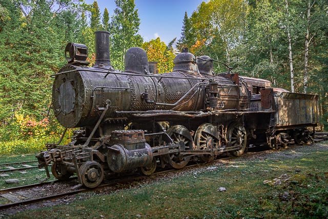
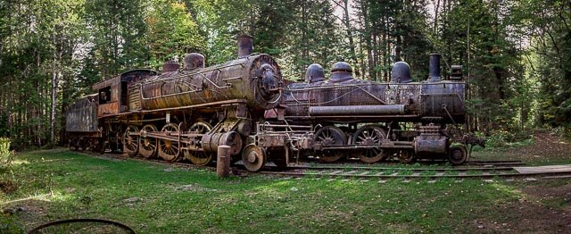
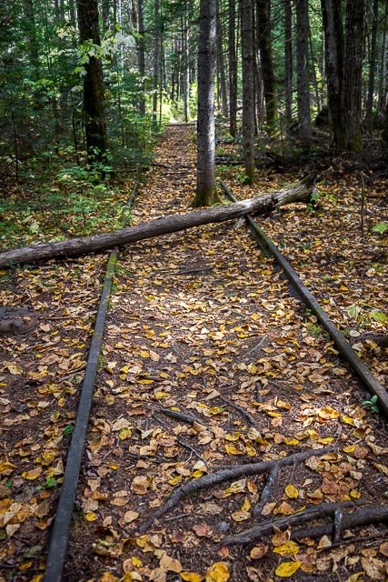
The Eagle Lake and West Branch Railroad was a forest railway built to transfer pulpwood between drainage basins in the Maine North Woods. The railroad operated only a few years in a location so remote the steam locomotives were never scrapped and remain exposed to the elements.
Spruce forests of the Maine North Woods were a source of pulpwood throughout the 20th century. Trees were bucked into 4-foot lengths and loaded onto sleds towed by draft animals or log haulers to the nearest river or lake. Log drives would float the pulpwood logs to a downstream paper mill when the snow and ice melted. Pulpwood harvested in the upper Allagash River drainage was destined for Great Northern Paper Company paper mill on the West Branch Penobscot River in Millinocket. The problem was getting the pulpwood out of the north-flowing Allagash River into the east-flowing Penobscot River.
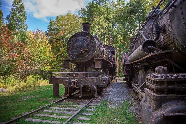
During the winter of 1926-27, Édouard Lacroix’s Madawaska Company used log haulers to move heavy railway equipment overland from Lac-Frontière, Quebec to Churchill Depot and then over frozen Churchill Lake and Eagle Lake. The log haulers delivered two steam locomotives, two Plymouth gasoline-powered switchers, miles of steel rail, and sixty railroad cars for carrying pulpwood. Each railroad car was 32 feet long with high, slatted sides to hold 12 cords of pulpwood. Three diesel-powered conveyors were built to lift pulpwood logs from Eagle Lake to a height of 25 feet over a distance of 225 feet. Each conveyor could fill a railroad car in 18 minutes. Lacroix completed the Umbazooksus and Eagle Lake Railroad to a pulpwood-unloading trestle at the north end of Umbazooksus Lake.
Paper demand declined through the Great Depression until pulpwood transfer ceased in 1933 after the railroad had carried nearly a million cords of pulpwood. The Plymouth switchers found work elsewhere while the steam locomotives waited in the engine house for improved economic conditions. Great Northern found trucks more cost effective than restoring the railroad when business returned following World War II.
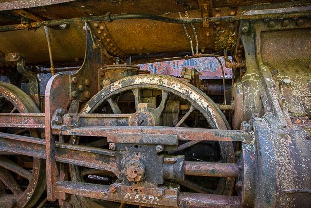
The engine house became a popular snowmobile destination in the 1960s; and fittings like gauges, bells, headlights, and number plates began to disappear from the locomotives before the wooden cab of engine #1 was destroyed when the engine house burned in 1969. The locomotive boiler jackets and asbestos lagging were removed in 1995 but the stripped locomotive shells remain a unique reminder of the industrial revolution in the Maine North Woods.
Remnants of the tramway and locomotives still survive in Maine’s Tramway Historic District, part of the Allagash Wilderness Waterway.
Where it is:
The abandoned train is located in the Maine North Woods
The North Maine Woods organization (NMW) is a cooperative effort by many private landowners in northwestern Maine to keep 3.5 million acres of forest land open to public use.
Visitors must pay a fee and pass through either manned or automated checkpoints.
All roads within the North Maine Woods are privately built and owned primarily for the purpose of managing and moving forest products.
The private landowners are willing to share their roads with members of the general public in order to visit the region’s many lakes and ponds and other natural resources for the purposes of hiking, hunting, fishing and berry picking to name a few.
ALL LOGGING TRUCKS AND OTHER COMMERCIAL VEHICLES HAVE THE RIGHT OF WAY. PLEASE PULL OVER WHEN MEETING THESE VEHICLES.
Give all logging trucks the right of way! The roads in this area were built to move wood products. For safety, please give logging trucks the same respect provided to fire trucks and ambulances. Logging trucks typically travel on the crown of the road for stability. When you see a truck coming from either direction, please pull over to let it pass safely.
• Obey posted speed limit signs. Maximum speed is 45 mph.
• Lights on for safety.
• Always travel on the right hand side.
• Be prepared to stop at all times.
• Never stop on a corner. Always give yourself at least 500 feet of visibility front and back.
• Reduce speeds on freshly graded roads. You are more likely to blow a tire or lose control because of loose gravel.
• Never block side roads. Even roads that seem unused may be needed in emergencies.
• Refrain from driving on newly constructed roads and roads that are “soft” from spring thawing or fall rainfall to prevent severe rutting.
• Do not linger on roads or stop on bridges. Most bridges in NMW are one lane.
• Park vehicles well off the road.
• Do not park in front of checkpoints. Use parking area provided
• All drivers must have a valid state or provincial driver’s license.
• All vehicles yield right of way to loaded trucks. All traffic yield to equipment working in roads. Pass only after operator’s acknowledgement.
Directions to the Tramwav / Trains from Telos Checkpoint:
It’s 29.5 mites to the Tramway Road from Telos Checkpoint or 21 miles from the Chamberlain parking lot, so watching your mileage will be helpful with these directions.
At the Chamberlain parking lot, turn left at the T intersection onto the Umabazookus Road.
Follow the Umabazookus Road for 8.0 miles. At the intersection Of the Guy Allen Road and the Grande Marche Road (also called the “Trans Canada”) bear right.
It is 15.0 miles from that turn to the “Tramway Road”. The following “checkpoints” will let you know you are on the right road. These are based on mileage from the
intersection of the Guy Allen Road and the Grande Marche/Trans Canada Road.
- After 8.0 miles on the Grande Marche Road, stay to your right at the 3-legged intersection. You will now be on the Edmond Roy Road (small orange sign indicating such)
- At 9.1 miles you will cross a small wooden bridge.
- At 10.5 miles you will come to another intersection. You will see signs for “Loon Lodge” directing you to the left. Stay straight at this intersection.
- At 11.4 miles you will drive past the “Chamberlain Lake Road” which is on your right.
- At 12.2 miles you will drive past a duster of logging camps.
- At 14.1 miies you will cross a wooden bridge at Allagash Stream (only 1 more mile to the Tramway Road).
- At 15.0 mites (+/-) you will see a dirt/gravel road on your right and signs showing “Tramway Road”. Take that right turn onto the Tramway Road.
- Follow that dirt/gravel road for 1.1 miles. You will then see a sign on your left directing you to turn right for the “Tramway”
- Follow that dirt/gravel road (it’s rough in sections but very driveable) for 1.5 miles. You will see a sign showing “Tramway Trail” on your left, pointing into the woods where there is a foot trail. You will also see bright orange flagging strips hanging in the trees at the beginning of the foot trail. Just after the “Tramway Trail” sign you see where they have widened the road on the left to allow for parking.
Maps:
Interactive Google Map
Use the map + – controls to zoom in and out, click and drag the to move the map, use the Map drop-down to change to “Map”, “Satellite”, “Hybrid”, or “Terrain” views. Drag the little man icon from the upper left corner to a map location for street level view.
GPS:
The Train Engines: 46°19’20.814″ N 69°22’30.504″ W
Tramway: 46°18’57.012″ N 69°22’42.882″ W
Cost:
Visitor Fees for the North Maine Woods
| As of 2020 | RESIDENT | NON-RESIDENT |
| Under 18 | Free Day Use & Camping | Free Day Use & Camping |
| Age 70 and Over | Free Day Use | Free Day Use |
| Per Person Per Day | $11 | $16 |
| Camping Per Night | $12 | $15 |
| Annual Day Use Registration | $140 | N/A |
| Annual Unlimited Day Use & Camping | $250 | N/A |
| Camping Only Annual Pass (Including seniors age 70 and over) | $125 | $125 |
Hours:
Access to the North Main Woods is and the trains is 24 hours a day (you must call and check in at the checkpoints when arriving if not staffed).
Facilities:
There are no Facilities, this is a very remote and rugged area. You need to be prepared if you have any problems or vehicle breakdowns.
Location Contact Information:
Abandoned Eagle Lake and West Branch Railroad Photo Gallery
Click Here for full page gallery
More Photographic Destinations in Maine:
Interactive Google Map
Use the map + – controls to zoom in and out, use the Map drop-down to change to “Map”, “Satellite”, “Hybrid”, or “Terrain” views. Drag the little man icon from the upper left corner to a map location for street level view. Click on a pushpin for more information about the Photographic Destination, then click on the title to go to the location page.
Click Here for Photographic Destinations by State