Fort Frederica

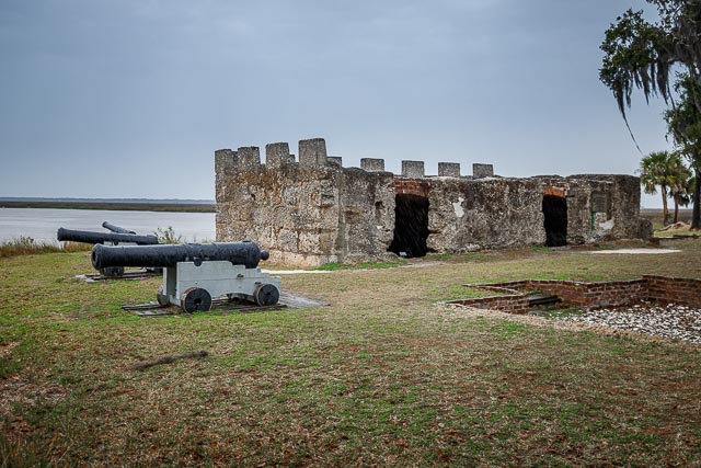
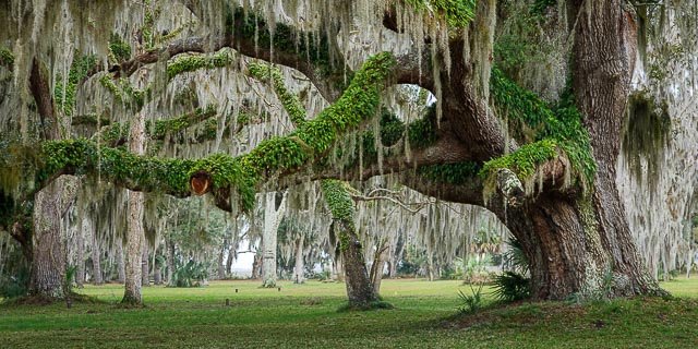
Walk beneath moss-draped live oaks and use your imagination to travel back in time as you explore the archeological remains of Fort Frederica. Once a thriving British town and fort founded in 1736 by General James Edward Oglethorpe, Fort Frederica was designed to defend the northern colonies against Spanish attack.
Fort Frederica National Monument, on St. Simons Island, Georgia, preserves the archaeological remnants of a fort and town built by James Oglethorpe between 1736 and 1748 to protect the southern boundary of the British colony of Georgia from Spanish raids. About 630 British troops were stationed at the fort.
A town of up to 500 colonial residents had grown up outside the fort; it was laid out following principles of the Oglethorpe Plan for towns in the Georgia Colony. The town was named Frederica, after Frederick, Prince of Wales, son of King George II. The monument was listed on the National Register of Historic Places on October 15, 1966.
In the 1742 battles of Bloody Marsh and Gully Hole Creek, forces under Oglethorpe successfully repulsed Spanish attempts to invade St. Simons Island. Afterward the Spanish no longer threatened the colony; in 1749 the government disbanded the garrison at Frederica. Soon the village fell into economic decline, and by 1755 it was mostly abandoned. The town survived a fire in 1758, but after a few more years, it was abandoned. Naturalist William Bartram visited the site in March, 1774. Though it was in ruins he noted that there was still a small garrison there.
Fort Frederica was documented and authorized as a National Monument on May 26, 1936, under the Franklin D. Roosevelt administration during the Great Depression. During this period, the Works Progress Administration (WPA) sponsored numerous surveys of historic areas and buildings across the country to identify, document and protect the resources for the future, as well as to provide employment.

Photography Information:
Although there is not a lot left of the fort or the village the grounds contain some magnificent Live Oak trees draped with Spanish Moss that make for some great photos.
Where it is:
Fort Frederica is located on St. Simons Island the largest barrier island in the Golden Isles of Georgia.
From I-95, heading North from Florida/Georgia border, take Exit 29. At end of ramp, turn right on Route 17 North. Follow Route 17 North, over the Sidney Lanier Bridge, to the intersection of F.J. Torras causeway. You will have to merge into the right hand turn lane before actually getting to the intersection. Take causeway over to Saint Simons Island. At end of causeway, get in left lane,and loop around, go to traffic light. Travel straight through light on Sea Island Road. Follow Sea Island Road to Frederica Road. At light, turn left onto Frederica. Follow Frederica to small traffic circle (roundabout). Take second exit at traffic circle (still on Frederica Road). Travel approximately 1 mile to entrance of park. It is on left, across the street from Wesley United Methodist Church.
From I-95, heading South from Savannah/South Carolina, take Exit 38. At end of ramp, turn left onto Golden Isles Parkway/Spur 25. Follow Parkway to Route 17 South. Turn right onto Glynn Ave (Route 17) and get in left lane as soon as possible. Follow Route 17 to F.J. Torres Causeway intersection. Turn left at light. Take causeway over to Saint Simons Island. At end of causeway, get in left lane,and loop around, go to traffic light. Travel straight through light on Sea Island Road. Follow Sea Island Road to Frederica Road. At light, turn left onto Frederica. Follow Frederica to small traffic circle (roundabout). Take second exit at traffic circle (still on Frederica Road). Travel approximately 1 mile to entrance of park. It is on left, across the street from Wesley United Methodist Church.
The Bloody Marsh unit of the park is located on Old Demere Road, near the Saint Simons Island airport.

Maps:
Interactive Google Map
Use the map + – controls to zoom in and out, click and drag the to move the map, use the Map drop-down to change to “Map”, “Satellite”, “Hybrid”, or “Terrain” views. Drag the little man icon from the upper left corner to a map location for street level view.

GPS:
31°13’23.868″ N 81°23’21.942″ W

Cost:
Fort Frederica National Monument is a fee-free park. There are no entrance or parking fees.
Hours:
Fort Frederica National Monument: The visitor center, restrooms,trails and park grounds are open from 9:00 am to 5:00 pm daily.
The park is closed on the following holidays:
Thanksgiving, Christmas Day and New Year’s Day

Facilities:
There is a visitor center with a gift shop and restrooms at the fort. Food and lodging are available on St. Simons Island.
Location Contact Information:

Fort Frederica Photo Gallery
Click Here for full page gallery
More Photographic Destinations in Georgia:
Interactive Google Map
Use the map + – controls to zoom in and out, use the Map drop-down to change to “Map”, “Satellite”, “Hybrid”, or “Terrain” views. Drag the little man icon from the upper left corner to a map location for street level view. Click on a pushpin for more information about the Photographic Destination, then click on the title to go to the location page.
Click Here for Photographic Destinations by State