Valley of Fire State Park

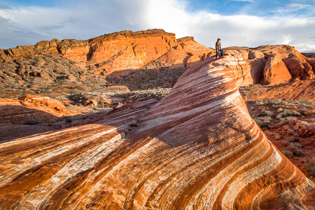
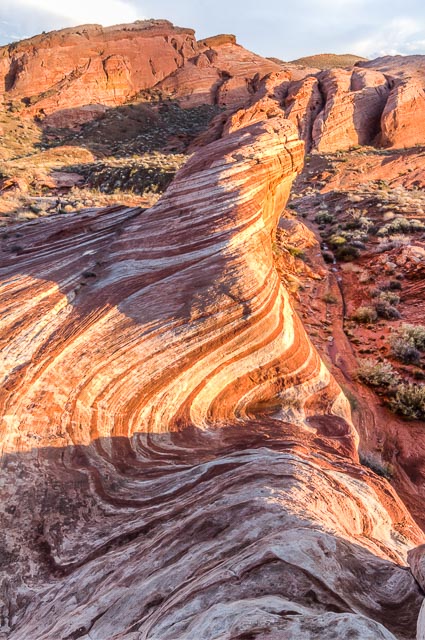
Fire Wave
One of the most photographed places in the Valley of Fire, the Fire Wave is a series of rings in the red sandstone. Past the visitor center you will come across the 1.5 mile fire wave trail that brings you to the swooping outlines of the fire wave.
Valley of Fire State Park
World-renowned for its 40,000 acres of bright red Aztec sandstone outcrops nestled in gray and tan limestone, Valley of Fire State Park contains ancient, petrified trees and petroglyphs dating back more than 2,000 years. The state park derives its name from red sandstone formations, the Aztec Sandstone, which formed from shifting sand dunes 150 million years ago. These features, which are the centerpiece of the park’s attractions, often appear to be on fire when reflecting the sun’s rays. It is Nevada’s oldest state park and was designated as a National Natural Landmark in 1968.
A Visitor Center provides exhibits on the geology, ecology, prehistory and history of the park and nearby region. The park also hosts an Annual Atlatl Competition in which participants test their skills with replicas of ancient spears. Open year round, the park has numerous campsites equipped with shaded tables, grills and water, as well as many intriguing trails to tempt hikers.
Where it is:
Valley of Fire is located 50 miles northeast of Las Vegas, at an elevation between 1,320–3,009 feet. It abuts the Lake Mead National Recreation Area on the east at the Virgin River confluence.
From the Las Vegas Strip: Take the I-15 North approximately 35-40 miles. Take Exit 75 and head East toward Valley of Fire/Lake Mead. Drive approximately 17 miles on Valley of Fire to the West Entrance Station.
You can also take the more scenic route and see Lake Mead as well: Take the I-15 North to Lake Mead Blvd. Turn Right and head East to Lakeshore Road (NV-166). Turn Right onto Northshore Drive (NV-167) and follow Northshore to the east entrance to Valley of Fire.
Fire Wave Trail is a newer trail in Valley of Fire State Park that does not appear on some older park maps. Begin from Parking Lot #3, the final parking area on White Does Road before it ends by White Domes Trail. Follow the clearly marked trail to the Fire Wave.

Maps:
Interactive Google Map
Use the map + – controls to zoom in and out, click and drag the to move the map, use the Map drop-down to change to “Map”, “Satellite”, “Hybrid”, or “Terrain” views. Drag the little man icon from the upper left corner to a map location for street level view.
GPS:
Trailhead coordinates: 36.4882, -114.52875 (36° 29′ 17.51″N 114° 31′ 43.50″W)

Cost:
Day use entrance fee: $10.00 per vehicle
Bike in: $2.00 per bike
Camping: $20.00 per night + $10.00 for sites with utility hook ups

Hours:
The park is open from sunrise to sunset unless camping in campgrounds or a group camping area. After sunset, activity is limited to those areas.
Open seven days a week, 365 days a year.
The visitor center is open daily from 9 a.m. to 4:00 p.m.
Valley of Fire State Park Photo Gallery
Click Here for full page gallery
More Photographic Destinations in Nevada
Interactive Google Map
Use the map + – controls to zoom in and out, use the Map drop-down to change to “Map”, “Satellite”, “Hybrid”, or “Terrain” views. Drag the little man icon from the upper left corner to a map location for street level view. Click on a pushpin for more information about the Photographic Destination, then click on the title to go to the location page.
Click Here for Photographic Destinations by State