
Pumpkin Patch Anza Borrego Desert

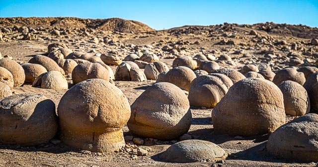
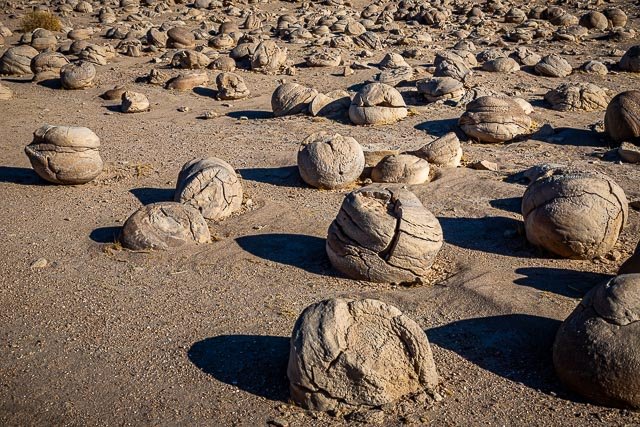
There aren’t any real pumpkins in this pumpkin patch, but if you use your imagination this city block sized patch of what geologist call concretions certainly resembles a real pumpkin patch.
Pumpkin Patch is a famous point of interest in Ocotillo Wells, near Anaz Borrego State Park because Of the abundance of the peculiar round rocks. These “pumpkins” are actually a unique geologic feature called concretions. Concretions are found all over the world, but are not all formed the same way. Geologists would agree, however, that the key ingredient is concrete, hence the name concretion.
After several years of wind erosion, these concretions have slowly emerged from the sand, while remaining stationary, and have been rounded by the wind. Unlike their life beneath the sand where they grew larger and larger, they are now exposed to the wind, slowly whittling away.
These concretions at Ocotillo Wells likely formed much like how a pearl forms. When loose sand is wetted, it will naturally Cement itself to a larger Object such as a pebble, piece of a shell, or even an insect body. When the water evaporates, the sand become hardened around the object. Although Ocotillo Wells’ pumpkins are rounded. concretions can become any shape and size.

Where it is:
The Pumpkin Patch is located in the Ocotillo Wells California Vehicular Recreation Area, just east of the Anza Borrego State Park boundary.
Getting to the Pumpkin Patch can be a little bit difficult and a high clearance 4 wheel drive is recommended. You will not be driving on roads, but instead a series of trails that primarily follow stretches of sand washes. A GPS navigation system will not get you there, it does not show the roads (trails). Be sure you have a map showing the off-road trails before beginning this trip.
There are multiple trails and routes to get to the pumpkin patch, the quickest and easiest way is to start your trip, from downtown Borrego Springs, the beginning of the dirt road can be reached by following S-22 (Borrego Salton Seaway) east from Christmas Circle for about 16 miles. Turn right onto a dirt road to a primitive BLM campground keep on the road which trends southeast, this will be crossover trail and eventually leads you into Tule Wash. Turn Right on Tule Wash and follow it until you reach the Pumpkin Patch. There will be a parking area with a picnic table and restrooms.

Maps:
Interactive Google Map
Use the map + – controls to zoom in and out, click and drag the to move the map, use the Map drop-down to change to “Map”, “Satellite”, “Hybrid”, or “Terrain” views. Drag the little man icon from the upper left corner to a map location for street level view.

GPS:
33°13’22.272″ N 116°4’7.008″ W
Cost:
There is no cost to visit the Pumpkin Patch.

Hours:
The area is open 24 hours per day.
Pumpkin Patch Anza Borrego Desert Photo Gallery
Click Here for full page gallery
More Photographic Destinations in California
Interactive Google Map
Use the map + – controls to zoom in and out, use the Map drop-down to change to “Map”, “Satellite”, “Hybrid”, or “Terrain” views. Drag the little man icon from the upper left corner to a map location for street level view. Click on a pushpin for more information about the Photographic Destination, then click on the title to go to the location page.
Click Here for Photographic Destinations by State