Louisiana Photographic Destinations

Sabine Pass Lighthouse Caddo Lake Atchafalaya Swamp Oak Alley Plantation Lafayette Cemetery No. 1 New Orleans Lake Martin Louisiana Swamp

Let me help you to find a great location in Louisiana for your next photography adventure.  I will list many lesser known destinations, as well as the famous “Icon Locations” for photography.  I will provide photos (Lots of Photos), location information,  consisting of what there is to photograph as well as other information about the destination.  I will give costs, maps, directions, contact information, and other essential information for a successful photo trip.  I will only post for locations that I have personally photographed to insure a quality guide to great locations for photography in Louisiana.

Interactive Google Map

Use the map  + – controls to zoom in and out, use the Map drop-down to change to “Map”, “Satellite”, “Hybrid”, or “Terrain” views.  Drag the little man icon from the upper left corner to a map location for street level view. Click on a pushpin for more information about the Photographic Destination, then click on the title to go to the location page.


Louisiana Photographic Destinations

Louisiana Destinations
Sabine Pass Lighthouse The Sabine Pass Lighthouse, or Sabine Pass Light as it was referred to by the United States Coast Guard, is a historic lighthouse, as part of a gulf coast light station, on the Louisiana side of the Sabine River, in Cameron Parish, across from the community of Sabine Pass, Texas. It was first lit in 1857 and was deactivated by the Coast Guard in 1952. One of only three built in the United States of similar design, the light was listed on the National Register of Historic Places as “Sabine Pass Lighthouse” on December 17, 1981. After years of being passed between various federal and state agencies, the surviving structure was sold at auction in 1985 to a pair of businessmen who had plans to build a marina or restaurant featuring the tower. These plans were never realized, and in 2001 they donated it to the Cameron Preservation Alliance, which has constructed a road to the abandoned and decaying tower, This preservation group has plans to make the 42-acre property into a parish historical museum. Cheniere Energy has built an LNG terminal with an improved gravel road passing the plant and ending at the lighthouse property, Historical Information: Designed and built by Captain Leadbetter. Considered to be a “sister” lighthouse to Aransas Pass, Timbalier & Barataria towers. 1861 – Extinguished by the Confederates. January, 1862 – The lamps, lens and clockwork were dismantled and crated for storage. April, 1863 – Union forces attacked twice, and damaged the lens. June, 1886 – Storm created an 8-foot tide which surrounded the tower with 5-feet of water. All the buildings on the site, except the lighthouse itself, were washed away. 1915 – A powerful hurricane caused the tower to vibrate, thus putting the clockworks out of order. The keepers had to turn the revolving lens by hand. 1952 – The lighthouse was discontinued and sometime during the next two years was transferred to the State of Louisiana. 1986 – The property was transferred into private hands. Where it is: The Sabine Pass Lighthouse is on private property and must be accessed by using Lighthouse Road which travels through Cheniere LNG Terminal. You must check in at the Cheniere Energy entrance to visit the lighthouse.  You must contact the Cameron Parish Library Branch at Johnson Bayou 4586 Gulf Beach Hwy, Cameron, LA 70631  (337) 569-2892 to get on the visitors’ list. You can drive to the lighthouse, but you may need a four-wheel drive if it has recently rained. If you visit at high tide there will be several inches of water surrounding the lighthouse, plan on having some wading boots. Maps: Interactive Google Map Use the map  + – controls to zoom in and out, click and drag the to move the map, use the Map drop-down to change to “Map”, “Satellite”, “Hybrid”, or “Terrain” views.  Drag the little man icon from the upper left corner to a map location for street level view. GPS: 29°42’59.502″ N 93°51’0.432″ W Cost: The lighthouse has free admission and you don’t need to get tickets in advance. Hours: There are no set hours to visit the lighthouse. Facilities: There are no facilities available at the lighthouse. Location Contact Information: Cameron Parish Library Branch at Johnson Bayou 4586 Gulf Beach Hwy, Cameron, LA 70631 337-569-2892 Monday – Thursday 9AM to 5PM Friday 8AM to 4PM Sabine Pass Lighthouse Photo Gallery Click Here for full page gallery   More Photographic Destinations in Louisiana Interactive Google Map Use the map  + – controls to zoom in and out, use the Map drop-down to change to “Map”, “Satellite”, “Hybrid”, or “Terrain” views.  Drag the little man icon from the upper left corner to a map location for street level view. Click on a pushpin for more information about the Photographic Destination, then click on the title to go to the location page. Click Here for Photographic Destinations by State    All the information in this post was believed to be accurate at the time it was published.  Please be sure to double check with the location before relying on this information as everything changes over time, especially hours, prices, and whether the location is still open.   Great Places for Great Photos   Let me help you to find a great location for your next photography adventure.  I will list many lesser-known destinations, as well as the famous "Icon Locations" for photography.  I will provide photos (Lots of Photos), location information, consisting of what there is to photograph as well as other information about the destination.  I will give costs, maps, directions, contact information, and other essential information for a successful photo trip.  I will only post for locations that I have personally photographed to ensure a quality guide to great locations for photography. If you know of great places that are not posted, please send me the details, I may just decide that is a place I need to go!     Greg Disch is a freelance photographer located in Arkansas. Greg specializes in nature, scenic, wildlife, and other outdoor subjects in Arkansas and other areas of the country.  Most of the images on this site are available for sale as prints, personal use, or rights managed stock photos. Greg offers both classroom instruction and in the field hands on photographic workshops. Classroom sessions are normally held in Fort Smith Arkansas, but arrangements can be made to bring a class to your group. All classes and workshops have small class sizes designed to provide an optimum student to instructor ratio, where you can get the personal attention, you need.  Most classes and workshops are limited to a maximum of six participants and will be held with a minimum of only two. If you are looking for a wonderful opportunity to get personal individual instruction, I do private workshops and classes at a location of your choice, whether doing a location photo shoot, coming to your home or business, traveling across the country on a road trip, or at my classroom.  This is a fantastic way to learn digital workflow and be sure that your computer equipment is properly configured for optimum performance. [...]Read more...
Oak Alley Plantation Oak Alley Plantation is a historic plantation located on the west bank of the Mississippi River, in the community of Vacherie Louisiana. Oak Alley is named for its distinguishing visual feature, an alley or canopied path, created by a double row of southern live oak trees about 800 feet long, planted in the early 18th century — long before the present house was built. The allée or tree avenue runs between the home and the River. The property was designated a National Historic Landmark for its architecture and landscaping, and for the agricultural innovation of grafting pecan trees, performed there in 1846–47 by an enslaved gardener. History Jacques and Celina Roman The Bon Séjour plantation, as Oak Alley was originally named, was established to grow sugarcane, by the French Creole Valcour Aime when he purchased the land in 1830. Aime, known as the “King of Sugar,” was one of the wealthiest men in the South. In 1836, Valcour Aime exchanged this piece of property with his brother-in-law Jacques Télesphore Roman for a plantation owned by Roman. The following year Jacques Roman began building the present mansion under the oversight of George Swainy and entirely with enslaved labor. The mansion was completed in 1839. Roman’s father-in-law, Joseph Pilié, was an architect and probably designed the house. The most noted slave who lived at Oak Alley Plantation was named Antoine. He was listed as “Antoine, 38, Creole Negro gardener/expert grafter of pecan trees,” with a value of $1,000 in the inventory of the estate conducted upon J.T. Roman’s death. Antoine was a master of the techniques of grafting, and after trial with several trees, succeeded in the winter of 1846 in producing a variety of pecan that could be cracked with one’s bare hands; the shell was so thin it was dubbed the “paper shell” pecan. It was later named the Centennial Variety when entered in competition at the 1876 Centennial Exposition in Philadelphia, where it won a prize. The trees may be found throughout southern Louisiana, where the pecan was once a considerable cash crop. Although Antoine’s original trees were cleared for more sugar cane fields after the Civil War, a commercial grove had been planted at nearby Anita Plantation. Unfortunately, the Anita Crevasse (river break) of 1990 washed away Anita Plantation and all remains of the original Centennial pecans. Jacques Roman died in 1848 of tuberculosis and the estate began to be managed by his wife, Marie Therese Josephine Celina Pilié Roman (1816–1866). Celina did not have a skill for managing a sugar plantation and her heavy spending nearly bankrupted the estate. In 1859 her son, Henri, took control of the estate and tried to turn things around. The plantation was not physically damaged during the American Civil War, but the economic dislocations of the war and the end of slavery made it no longer economically viable; Henri became severely in debt, mainly to his family. In 1866, his uncle, Valcour Aime and his sisters, Octavie and Louise, put the plantation up for auction and it was sold for $32,800 to John Armstrong. Andrew and Josephine Stewart Successive owners could not afford the cost of upkeep and by the 1920s the buildings had fallen into disrepair. In 1925 the property was acquired by Andrew Stewart as a gift to his wife, Josephine, who commissioned architect Richard Koch to supervise extensive restoration and modernize the house. As a virus had wiped out the sugarcane industry in the early 1900s, the Stewarts ran Oak Alley Plantation as a cattle ranch. Josephine had grown up on a cattle ranch in Texas and was familiar with this type of industry. Sugar cane cultivation was reintroduced at the plantation in the 1960s. The Stewarts were the last owners to live in residence. Josephine Stewart left the historic house and grounds to the Oak Alley Foundation when she died in 1972, which opened them to the public. What to Photograph Photography is welcomed on the grounds at Oak Alley Plantation, except for the “Big House” exhibit. Videotaping and video-streaming are prohibited during guided visits. For safety reasons, the use of “drones” or any aerial photography devices is not permitted. Photo sessions held on the property require and additional fee. Where it is: Located within an hour from New Orleans and Baton Rouge on the Great River Road. Directions from New Orleans to Oak Alley Plantation Take Interstate 10 (West) to Interstate 310 (South). Exit #220 – for Boutte. Continue on Interstate 310 across the Destrehan/Luling Bridge to exit #10 – for Donaldsonville, Highway 3127. Travel twenty-three buy diazepam online without prescription (23) miles on Highway 3127 to major intersection with Highway 20. Turn right on Highway 20, travel three (3) miles to Highway 18, turn left and travel three (3) miles to Oak Alley Plantation. Alternate rouge: Take Interstate 10 (West) to the Gramercy Exit #194. Turn left on Highway 641 (South). Follow Highway 641 (South), which will turn into Highway 3213. Continue on Highway 3213 over the Veteran’s Memorial Bridge (also known as Gramercy/Wallace Bridge). Take the exit on the down ramp toward Vacherie. Turn left onto Highway 18 and travel seven and one-half (7 1/2 ) miles to Oak Alley Plantation. Directions from New Orleans International Airport to Oak Alley Plantation Turn right out of the airport onto Highway 61 (West), also known as Airline Highway. Travel approximately four (4) miles to Interstate 310 (South). Continue on Interstate 310 across the Destrehan/Luling Bridge to exit #10 – for Donaldsonville, Highway 3127. Travel twenty-three (23) miles on Highway 3127 to major intersection with Highway 20. Turn right on Highway 20, travel three (3) miles to Highway 18, turn left and travel three (3) miles to Oak Alley Plantation. Alternate route: turn right out of the airport onto Highway 61 (West), also known as Airline Highway. Travel approximately four (4) miles to Interstate 310 (North). Continue on Interstate 310 (North) to the exit for Interstate 10 (West) to Baton Rouge. Continue on Interstate 10 (West) to the Gramercy Exit #194. Turn left on Highway 641 (South). Follow Highway 641 (South), which will turn into Highway 3213. Continue on Highway 3213 over the Veteran’s Memorial Bridge (also known as Gramercy/Wallace Bridge). Turn left onto Highway 18 and travel seven and one-half (7 1/2 ) miles to Oak Alley Plantation. Directions from Baton Rouge to Oak Alley Plantation Take Interstate 10 (East) to the Lutcher/Mississippi River Bridge exit #194. Turn right on Highway 641 (South). Follow Highway 641 (South), which will turn into Highway 3213. Continue on Highway 3213 over the Veteran’s Memorial Bridge (also known as Gramercy/Wallace Bridge). Take the exit on the down ramp toward Vacherie. Turn left onto Highway 18 and travel seven and one-half miles to Oak Alley Plantation. Maps: Interactive Google Map Use the map  + – controls to zoom in and out, click and drag the to move the map, use the Map drop-down to change to “Map”, “Satellite”, “Hybrid”, or “Terrain” views.  Drag the little man icon from the upper left corner to a map location for street level view. GPS N 30.00500 W 90.77889 Cost: Admission to the historic site requires a ticket, which may be purchased at the Ticket Booth upon arrival.  Admission includes access to the exhibits:”Slavery at Oak Alley”, Civil War Encampment, the “Big House”, the Blacksmith Shop, Sugarcane Theater and additional highlighted points of interest on the 28 historic acres. Plantation Admissions    Admission type                  Single admission  Adults (19 yrs & older                   $25.00   (+tax) Youth (13 to 18 yrs old)                   $10.00  (+ tax) Children (6 to 12 yrs old) 5 yrs & younger                     $7.00  (+ tax)                                  Free Friends of Oak Alley Members (Learn more)  Free for Member and 1 guest   Discounts offered with ID:  AAA, Military, Senior 65+, First Responders, Teachers and Students 19+  Hours: Hours of Operations: 9:00 a.m. – 5:00 p.m. daily Location Contact Information: 3645 Highway 18 (Great River Road) Vacherie, Louisiana USA 70090 PHONE: (225) 265-2151 or (800) 44ALLEY FAX: (225) 265-7035 Email: info@oakalleyplantation.com Links https://www.oakalleyplantation.org/ Oak Alley Plantation Photo Gallery Click Here for full page gallery More Photographic Destinations in Louisiana: Interactive Google Map Use the map  + – controls to zoom in and out, use the Map drop-down to change to “Map”, “Satellite”, “Hybrid”, or “Terrain” views.  Drag the little man icon from the upper left corner to a map location for street level view. Click on a pushpin for more information about the Photographic Destination, then click on the title to go to the location page. Click Here for Photographic Destinations by State    All the information in this post was believed to be accurate at the time it was published.  Please be sure to double check with the location before relying on this information as everything changes over time, especially hours, prices, and whether the location is still open.   Great Places for Great Photos   Let me help you to find a great location for your next photography adventure.  I will list many lesser-known destinations, as well as the famous "Icon Locations" for photography.  I will provide photos (Lots of Photos), location information, consisting of what there is to photograph as well as other information about the destination.  I will give costs, maps, directions, contact information, and other essential information for a successful photo trip.  I will only post for locations that I have personally photographed to ensure a quality guide to great locations for photography. If you know of great places that are not posted, please send me the details, I may just decide that is a place I need to go!     Greg Disch is a freelance photographer located in Arkansas. Greg specializes in nature, scenic, wildlife, and other outdoor subjects in Arkansas and other areas of the country.  Most of the images on this site are available for sale as prints, personal use, or rights managed stock photos. Greg offers both classroom instruction and in the field hands on photographic workshops. Classroom sessions are normally held in Fort Smith Arkansas, but arrangements can be made to bring a class to your group. All classes and workshops have small class sizes designed to provide an optimum student to instructor ratio, where you can get the personal attention, you need.  Most classes and workshops are limited to a maximum of six participants and will be held with a minimum of only two. If you are looking for a wonderful opportunity to get personal individual instruction, I do private workshops and classes at a location of your choice, whether doing a location photo shoot, coming to your home or business, traveling across the country on a road trip, or at my classroom.  This is a fantastic way to learn digital workflow and be sure that your computer equipment is properly configured for optimum performance. [...]Read more...
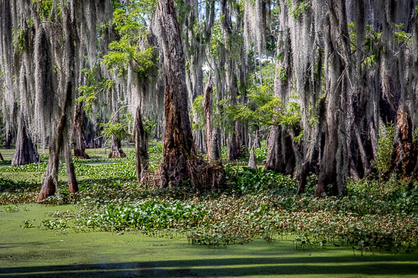
Lake Martin Lake Martin, located in St. Martin Parish, is a wildlife preserve and one of Louisiana’s swamp lands. The swamp lands are home to a few trails as well as many different kinds of animals such as herons, egrets, ibis, bullfrogs, cottonmouths, alligators, and coypu (nutria) rats. Lake Martin is home to a swampy ecosystem that supports globally significant numbers of species of colonial nesting water birds and native plants. Lake Martin is one of Louisiana’s largest nesting colonies for many species of water birds. Some of these species include the Anhinga, Great Blue Heron, Great Egret, Snowy Egret, Little Blue Heron, Tri-colored Heron, Cattle Egret, Black-crowned Night Heron, White Ibis, and Roseate Spoonbill. Lake Martin is also used as a rookery year round for many species. Lake Martin is also home to a substantial nesting population of alligators, which can typically be spotted from Rookery Road, which runs right along the edge of the lake. The preserve is currently owned and managed by the Nature Conservancy, who works to keep the lake clean and ecologically sound. They also maintain a visitor’s center and a boardwalk over the swamp at the South end of the lake. What to Photograph: The swamp and wildlife, I would definitely recommend taking one of the swamp tours. Where it is: FROM LAFAYETTE, LA:   Take I-10 exit 109 for LA-328 toward Breaux Bridge 0.3 mi Follow LA-328 S/Rees St, LA-31/S Main St and Lake Martin to Rookery Rd 13 min (6.6 mi) Turn right onto LA-328 S/Rees St (signs for Breaux Bridge) 1.7 mi Turn right onto E Bridge St 0.2 mi Turn left onto LA-31/S Main St 2.7 mi Turn right onto Lake Martin 1.8 mi Turn left onto Rookery Rd FROM BATON ROUGE, LA: Take I-10 exit 115 for LA-347 toward Henderson/Cecilia 0.3 mi Continue on LA-347. Take Doyle Melancon Rd and Lake Martin to Rookery Rd in 6 17 min (10.3 mi) Turn left onto LA-347 (signs for Henderson) 3.4 mi Turn left onto Andrew Broussard/Doyle Melancon Rd/Par Rd 214 Continue to follow Doyle Melancon Rd 3.0 mi Turn right onto Clayton Castille Rd 0.9 mi Turn right onto LA-347 0.2 mi Turn left onto LA-351 0.7 mi Turn right onto LA-31 0.3 mi Turn left onto Lake Martin 1.8 mi Turn left onto Rookery Rd Maps: Interactive Google Map Use the map  + – controls to zoom in and out, click and drag the to move the map, use the Map drop-down to change to “Map”, “Satellite”, “Hybrid”, or “Terrain” views.  Drag the little man icon from the upper left corner to a map location for street level view. Cost: There is no cost to visit Lake Martin, swamp tours will run about $20 per adult. Facilities: Champagne’s Cajun Swamp Tours. The store provides an ATM Machine, drinks,chips, snacks, sandwiches, and the only restroom facilities at Lake Martin, alternate restrooms are miles away. Fishing supplies: live bait,  and kayak & canoe rentals are available (life jackets included). Links: Champagne’s Cajun Swamp Tours The Nature Conservancy Cypress Island Preserve Location Contact Information: CHAMPAGNE’S CAJUN SWAMP TOURS 1151 Rookery Rd Breaux Bridge, LA 70517 Hours: Mon-Sun 8am – till Please note: times may vary by season 337-230-4068 champagnestours@gmail.com Lake Martin Louisiana Swamp Photo Gallery Click Here for full page gallery More Photographic Destinations in Louisiana: Interactive Google Map Use the map  + – controls to zoom in and out, use the Map drop-down to change to “Map”, “Satellite”, “Hybrid”, or “Terrain” views.  Drag the little man icon from the upper left corner to a map location for street level view. Click on a pushpin for more information about the Photographic Destination, then click on the title to go to the location page. Click Here for Photographic Destinations by State    All the information in this post was believed to be accurate at the time it was published.  Please be sure to double check with the location before relying on this information as everything changes over time, especially hours, prices, and whether the location is still open.   Great Places for Great Photos   Let me help you to find a great location for your next photography adventure.  I will list many lesser-known destinations, as well as the famous "Icon Locations" for photography.  I will provide photos (Lots of Photos), location information, consisting of what there is to photograph as well as other information about the destination.  I will give costs, maps, directions, contact information, and other essential information for a successful photo trip.  I will only post for locations that I have personally photographed to ensure a quality guide to great locations for photography. If you know of great places that are not posted, please send me the details, I may just decide that is a place I need to go!     Greg Disch is a freelance photographer located in Arkansas. Greg specializes in nature, scenic, wildlife, and other outdoor subjects in Arkansas and other areas of the country.  Most of the images on this site are available for sale as prints, personal use, or rights managed stock photos. Greg offers both classroom instruction and in the field hands on photographic workshops. Classroom sessions are normally held in Fort Smith Arkansas, but arrangements can be made to bring a class to your group. All classes and workshops have small class sizes designed to provide an optimum student to instructor ratio, where you can get the personal attention, you need.  Most classes and workshops are limited to a maximum of six participants and will be held with a minimum of only two. If you are looking for a wonderful opportunity to get personal individual instruction, I do private workshops and classes at a location of your choice, whether doing a location photo shoot, coming to your home or business, traveling across the country on a road trip, or at my classroom.  This is a fantastic way to learn digital workflow and be sure that your computer equipment is properly configured for optimum performance. [...]Read more...
Lafayette Cemetery No. 1 New Orleans Lafayette Cemetery No. 1, 1420 Washington Avenue, established in 1833 by the City of Lafayette. The square was acquired from Cornelius Hurst and the cemetery laid out by Benjamin Buisson, city surveyor. Part of the Livaudais Plantation which had been subdivided into city squares in 1832. The cemetery contains many fine and historic tombs, among them those of Samuel Jarvis Peters, father of the New Orleans public school system, and General Harry T. Hays, distinguished confederate general.  At Lafayette Cemetery No. 1 are buried many persons of German and Irish origin who lived in the City of Lafayette. The typical New Orleans burial vaults adjoining Washington Avenue were restored and magnolia trees on the cross aisle replanted by the City of New Orleans when Victor H. Schiro was mayor. The cemetery has been active since 1833 and still has burials occurring.  There are about 1,000 tombs and an estimated 7,000 people buried in Lafayette #1. It is a city block in size. The cemetery is also not racially or religiously segregated and contains over 26 nationalities. Notable tombs include the Jefferson Fire Co. #22’s society tomb with an ornate fire pump adhered, an Odd Fellows tomb, and the metal tomb that inspired the author Anne Rice when writing the novel Interview with a Vampire.  The Open Koneig’s tomb is a favorite for people to peek inside and see the inner workings of a tomb. Lafayette #1 is also the most filmed cemetery in New Orleans.  Most recently scenes from The Originals on the CW Network, and NCIS: New Orleans have been filmed inside.  Tour participants have spotted Mark Ruffalo, Ryan Reynolds, and Samuel L. Jackson inside.  In addition, the movie Double Jeopardy was filmed inside (see video below). Not to forget, tour guide Sarah’s favorite is the music video Right Stuff by the New Kids on the Block. The cemetery was dedicated to Theodore Von LaHache in 1823, a musician who founded the New Orleans Philharmonic Society. The dedication hangs below the front gate entrance on Washington Avenue. Lafayette Cemetery #1 is now a tourist destination for visitors who want to experience New Orleans’ “Cities of the Dead.” What to Photograph A non-denominational, non-segregated cemetery from 1833 with about 1000 above ground tombs. Where it is: Location: The cemetery is located at 1416-1498 Washington Avenue in New Orleans, Louisiana.   The entrance to the cemetery is located on Washington Street near the Commander’s Palace restaurant. The Lafayette Cemetery No. 1 is located in the Garden District of New Orleans about a 15 minute drive from the French Quarter.  There are  two entrances one on Washington Ave. and one on 6th Street.  It is an easy walk from the streetcar or the #11 Magazine Street bus on Washington Avenue to the bordering streets of Coliseum and Prytania. Maps: Interactive Google Map Use the map  + – controls to zoom in and out, click and drag the to move the map, use the Map drop-down to change to “Map”, “Satellite”, “Hybrid”, or “Terrain” views.  Drag the little man icon from the upper left corner to a map location for street level view. Cost: There is no cost to enter the cemetery, however there are many tours available at a cost. Hours: It’s open seven days a week from 7:00 am to 3:00 pm, although it’s closed on most major holidays. Facilities: There are no facilities in the cemetery Location Contact Information: Address: 1416-1498 Washington Ave, New Orleans, LA 70130 Phone: (504) 658-3781 Lafayette Cemetery No. 1 New Orleans Photo Gallery Click Here for full page gallery More Photographic Destinations in Louisiana: Interactive Google Map Use the map  + – controls to zoom in and out, use the Map drop-down to change to “Map”, “Satellite”, “Hybrid”, or “Terrain” views.  Drag the little man icon from the upper left corner to a map location for street level view. Click on a pushpin for more information about the Photographic Destination, then click on the title to go to the location page. Click Here for Photographic Destinations by State    All the information in this post was believed to be accurate at the time it was published.  Please be sure to double check with the location before relying on this information as everything changes over time, especially hours, prices, and whether the location is still open.   Great Places for Great Photos   Let me help you to find a great location for your next photography adventure.  I will list many lesser-known destinations, as well as the famous "Icon Locations" for photography.  I will provide photos (Lots of Photos), location information, consisting of what there is to photograph as well as other information about the destination.  I will give costs, maps, directions, contact information, and other essential information for a successful photo trip.  I will only post for locations that I have personally photographed to ensure a quality guide to great locations for photography. If you know of great places that are not posted, please send me the details, I may just decide that is a place I need to go!     Greg Disch is a freelance photographer located in Arkansas. Greg specializes in nature, scenic, wildlife, and other outdoor subjects in Arkansas and other areas of the country.  Most of the images on this site are available for sale as prints, personal use, or rights managed stock photos. Greg offers both classroom instruction and in the field hands on photographic workshops. Classroom sessions are normally held in Fort Smith Arkansas, but arrangements can be made to bring a class to your group. All classes and workshops have small class sizes designed to provide an optimum student to instructor ratio, where you can get the personal attention, you need.  Most classes and workshops are limited to a maximum of six participants and will be held with a minimum of only two. If you are looking for a wonderful opportunity to get personal individual instruction, I do private workshops and classes at a location of your choice, whether doing a location photo shoot, coming to your home or business, traveling across the country on a road trip, or at my classroom.  This is a fantastic way to learn digital workflow and be sure that your computer equipment is properly configured for optimum performance. [...]Read more...
Caddo Lake Caddo Lake is a truly unique photography destination. Bald cypress trees draped with Span­ish moss tower over the maze of bayous, sloughs and ponds of Caddo Lake. Caddo Lake (French: Lac Caddo) is a 25,400-acre lake and bayou (wetland) on the border between Texas and Louisiana. The lake is named after the Southeastern culture of Native Americans called Caddoans or Caddo, who lived in the area until their expulsion in the 19th century. It is an internationally protected wetland and includes one of the largest flooded cypress forests in the United States. According to Caddo legend, the lake was formed by the 1811–12 New Madrid earthquakes. There may be some truth to the legend, as Reelfoot Lake in Tennessee was formed by that earthquake. Most geologists feel the lake was formed, either gradually or catastrophically, by the “Great Raft”, a 100-mile log jam on the Red River in Louisiana, possibly by flooding the existing low-lying basin. Caddo Lake has been utilized by Native Americans for thousands of years, but substantial commercial development would only begin with invention of the steamboat and US annexation of Louisiana and Texas by treaty  in the 19th century. The cities of Port Caddo, Swanson’s Landing, and Jefferson in Texas, and Mooringsport in Louisiana, had thriving riverboat ports on the lake. Gradually as the log jams were removed in the lake and on the Red River by Captain Henry Miller Shreve and then by the Army Corps of Engineers, the lake changed shape and eventually fell over 10 feet, destroying the East Texas ports and their riverboat industry. Industry once again came to Caddo Lake with the discovery of oil beneath it. The world’s first over water oil platform was completed in Caddo Lake in 1911. The Ferry Lake No. 1 was erected by Gulf Refining Company. The well bottomed at 2,185 feet and produced 450 barrels per day. Wildlife inhabiting Caddo Lake includes owls, snakes, frogs, waterfowl, bobcats, river otters, beavers, eagles, and alligators. The lake is currently “under siege” by a fast-spreading, Velcro-like aquatic fern, Salvinia molesta, also known as Giant Salvinia.  Accidentally introduced to the lake by boaters, the noxious weed doubles in size every two to four days, rapidly killing off life below the surface. Efforts at removing the weed have included biological means via beetles that normally eat the weed but cannot survive the Texas cold and now include herbicide. Photography Information: In order to fully experience the haunting beauty of Caddo Lake you need to travel the lake by boat.  I would definitely recommend a guided sunrise boat tour for photography, if you don’t know the lake you could easily get lost. Where it is: Caddo Lake is located between Marshall, Texas and Shreveport, Louisiana in Uncertain, Texas.  The Texas side of the lake is the major swamp area while the Louisiana side is more open water. Directions to Shady Glade Resort From Shreveport, LA Take I-20 west bound 21.5 miles and take FM-134/Caddo Lake exit. Turn right onto FM-134 heading north and go 10 miles. In Leigh community, FM-134 makes a left turn. Turn left and follow FM-134  5.0 miles to Karnack. In Karnack, turn right on Old FM-134, which is 2 blocks north of the Post Office. Go .2 miles and turn right on FM-2198. Follow FM-2198 for 4.4 miles and turn left on Cypress Drive. Go 1/2 mile to Shady Glade Resort.   From Dallas, TX Take I-20 East and go approximately 120 miles to US-59/Marshall, TX exit. Turn left on US-59 and go 4.3 miles to Texas Hwy 43. Turn right on TX-43 and go 13.5 miles to FM-2198. Turn right on FM-2198 and go 4.8 miles to Cypress Drive. Turn left on Cypress Drive and go 1/2 mile to Shady Glade Resort.   From Houston, TX Take US-59 North 220 miles to Marshall, TX. Turn right on Texas Hwy 43 and go 13.5 miles to FM-2198. Turn right on FM-2198 and 4.8 miles to Cypress Drive. Turn left on Cypress Drive and go 1/2 mile to Shady Glade Resort. From Oklahoma City, OK Take I-40 East 86.3 miles and merge onto Indian Nation Turnpike south. Go 88.5 miles to Antlers, OK. Stay on the Indian Nation Turnpike south for 16 miles. Indian Nation Turnpike will become US-271 south. Take US-271 south towards Hugo/Paris and go 22.8 miles. Take the US-82E/TX-286 Loop E/US-271S ramp. Merge onto US-271 south and go 52.3 miles to Mt. Pleasant, TX. Stay straight and exit onto TX-49. Go 48.8 miles to Jefferson, TX. At the intersection with US-59, continue strait and US-49 becomes Polk St. Follow Polk St for approximately 1/2 mile and bear right thru downtown Jefferson. Continue for approximately 1-1/4 miles and turn left on FM-134. Go 11.5 miles to the intersection with Hwy 43. Continue thru the intersection and the road becomes FM-2198. Go 4.4 miles and turn left on Cypress. Go 1/2 mile to Shady Glade Resort.   From Little Rock, AR Take I-30 west and go 141.3 miles. Take the US-59 south exit and go 20.6 miles. Take TX-43 south and go 30.6 miles. Turn left on FM-2198 and go 4.8 miles. Turn left on Cypress Drive. Go 1/2 mile to Shady Glade Resort.     Maps: Interactive Google Map Use the map  + – controls to zoom in and out, click and drag the to move the map, use the Map drop-down to change to “Map”, “Satellite”, “Hybrid”, or “Terrain” views.  Drag the little man icon from the upper left corner to a map location for street level view. GPS: Shade Glade Resort Café and Marina.  32°42’45.906″ N 94°7’12.528″ W Cost: There is no cost to boat on Caddo Lake. Caddo Lake State Park Adult: $4 Daily Child 12 Years and Under: Free Hours: The lake is always open. Facilities: There are several restaurants and marinas in Uncertain Texas. Location Contact Information: Caddo Lake State Park 245 Park Road 2 Karnack, TX 75661 (903) 679-3351 Caddo Lake Photo Gallery Click Here for full page gallery   More Photographic Destinations in Texas: Interactive Google Map Use the map  + – controls to zoom in and out, use the Map drop-down to change to “Map”, “Satellite”, “Hybrid”, or “Terrain” views.  Drag the little man icon from the upper left corner to a map location for street level view. Click on a pushpin for more information about the Photographic Destination, then click on the title to go to the location page. Click Here for Photographic Destinations by State    All the information in this post was believed to be accurate at the time it was published.  Please be sure to double check with the location before relying on this information as everything changes over time, especially hours, prices, and whether the location is still open.   Great Places for Great Photos   Let me help you to find a great location for your next photography adventure.  I will list many lesser-known destinations, as well as the famous "Icon Locations" for photography.  I will provide photos (Lots of Photos), location information, consisting of what there is to photograph as well as other information about the destination.  I will give costs, maps, directions, contact information, and other essential information for a successful photo trip.  I will only post for locations that I have personally photographed to ensure a quality guide to great locations for photography. If you know of great places that are not posted, please send me the details, I may just decide that is a place I need to go!     Greg Disch is a freelance photographer located in Arkansas. Greg specializes in nature, scenic, wildlife, and other outdoor subjects in Arkansas and other areas of the country.  Most of the images on this site are available for sale as prints, personal use, or rights managed stock photos. Greg offers both classroom instruction and in the field hands on photographic workshops. Classroom sessions are normally held in Fort Smith Arkansas, but arrangements can be made to bring a class to your group. All classes and workshops have small class sizes designed to provide an optimum student to instructor ratio, where you can get the personal attention, you need.  Most classes and workshops are limited to a maximum of six participants and will be held with a minimum of only two. If you are looking for a wonderful opportunity to get personal individual instruction, I do private workshops and classes at a location of your choice, whether doing a location photo shoot, coming to your home or business, traveling across the country on a road trip, or at my classroom.  This is a fantastic way to learn digital workflow and be sure that your computer equipment is properly configured for optimum performance. [...]Read more...
Atchafalaya Swamp The Atchafalaya Basin, or Atchafalaya Swamp, is the largest wetland and swamp in the United States. Located in south central Louisiana, it is a combination of wetlands and river delta area where the Atchafalaya River and the Gulf of Mexico converge. The river stretches from near Simmesport in the north through parts of eight parishes to the Morgan City southern area. The Atchafalaya is different among Louisiana basins because it has a growing delta system with wetlands that are almost stable. The basin contains about 70% forest habitat and about 30% marsh and open water. It contains the largest contiguous block of forested wetlands remaining in the lower Mississippi River valley and the largest block of floodplain forest in the United States. Best known for its iconic cypress-tupelo swamps, at 260,000 acres, this block of forest represents the largest remaining contiguous tract of coastal cypress in the US. The Atchafalaya Basin and the surrounding plain of the Atchafalaya River is filled with bayous, bald cypress swamps, and marshes, which give way to brackish estuarine conditions, and end in the Spartina grass marshes where the Atchafalaya River meets the Gulf of Mexico. It includes the Lower Atchafalaya River, Wax Lake Outlet, Atchafalaya Bay, and the Atchafalaya River and bayous Chêne, Boeuf, and Black navigation channel. The Basin, which is susceptible to long periods of deep flooding, is sparsely inhabited. The Basin is about 20 miles in width from east to west and 150 miles in length. The Basin is the largest existing wetland in the United States with an area of 1,400,000 acres, including the surrounding swamps outside of the levees that historically were connected to the Basin. The Basin contains nationally significant expanses of bottomland hardwoods, swamplands, bayous, and back-water lakes. The Basin’s thousands of acres of forest and farmland are home to the Louisiana black bear, which has been on the United States Fish and Wildlife Service threatened list since 1992. The few roads that cross the Basin follow the tops of levees. Interstate 10 crosses the basin on elevated pillars on a continuous 18.2 mile bridge from Grosse Tete, Louisiana, to Henderson, Louisiana. When it was built in 1973, the Atchafalaya Basin Bridge was the longest in the United States. Its 18-mile stretch offers a view of the wetlands from Interstate 10. What to Photograph At almost a million acres, the Atchafalaya River Basin is North America’s largest floodplain swamp. The Atchafalaya Basin’s deep woods, fertile marshes, and meandering waters provide essential habitat for more than 300 species of wildlife and 100 different aquatic species, as well as a rich diversity of native plants. It is larger than the Florida Everglades It’s five times more productive than any other river basin in North America About 65 species of reptiles and amphibians inhabit and Basin Over 250 known species of birds fly in the Basin Other species of animals found in the area include black bear, nutria, fox, muskrat, beaver, otter and raccoon The Basin is home to the largest nesting concentration of bald eagles in the south central United States There are more than 100 different species of fish and aquatic life in the Basin The Basin has an estimated average annual commercial harvest of nearly 22 million pounds of crawfish The Basin contains the largest contiguous bottomland hardwood forest in North America and is the largest overflow alluvial hardwood swamp in the United States Where it is: Located in south central Louisiana, it is a combination of wetlands and river delta area where the Atchafalaya River and the Gulf of Mexico converge. Maps: Interactive Google Map Use the map  + – controls to zoom in and out, click and drag the to move the map, use the Map drop-down to change to “Map”, “Satellite”, “Hybrid”, or “Terrain” views.  Drag the little man icon from the upper left corner to a map location for street level view. Click here for larger map Cost: There is no cost to enter the Atchafaylaya Swamp, however the best way to see it is by boat, there are virtually no roads to access the area.  Swamp tours are available from many locations and is the best way to get into the swamp. Location Contact Information: For visitor information, call the Atchafalaya Welcome Center at (337) 228-1094 Mailing Address: Louisiana Department of Culture, Recreation & Tourism P. O. Box 44243  Baton Rouge, , LA 70804-4243 Phone: (337) 228-1094 Links Atchafalaya National Heritage Area Atchafalaya Swamp Photo Gallery Click Here for full page gallery More Photographic Destinations in Louisiana: Interactive Google Map Use the map  + – controls to zoom in and out, use the Map drop-down to change to “Map”, “Satellite”, “Hybrid”, or “Terrain” views.  Drag the little man icon from the upper left corner to a map location for street level view. Click on a pushpin for more information about the Photographic Destination, then click on the title to go to the location page. Click Here for Photographic Destinations by State    All the information in this post was believed to be accurate at the time it was published.  Please be sure to double check with the location before relying on this information as everything changes over time, especially hours, prices, and whether the location is still open.   Great Places for Great Photos   Let me help you to find a great location for your next photography adventure.  I will list many lesser-known destinations, as well as the famous "Icon Locations" for photography.  I will provide photos (Lots of Photos), location information, consisting of what there is to photograph as well as other information about the destination.  I will give costs, maps, directions, contact information, and other essential information for a successful photo trip.  I will only post for locations that I have personally photographed to ensure a quality guide to great locations for photography. If you know of great places that are not posted, please send me the details, I may just decide that is a place I need to go!     Greg Disch is a freelance photographer located in Arkansas. Greg specializes in nature, scenic, wildlife, and other outdoor subjects in Arkansas and other areas of the country.  Most of the images on this site are available for sale as prints, personal use, or rights managed stock photos. Greg offers both classroom instruction and in the field hands on photographic workshops. Classroom sessions are normally held in Fort Smith Arkansas, but arrangements can be made to bring a class to your group. All classes and workshops have small class sizes designed to provide an optimum student to instructor ratio, where you can get the personal attention, you need.  Most classes and workshops are limited to a maximum of six participants and will be held with a minimum of only two. If you are looking for a wonderful opportunity to get personal individual instruction, I do private workshops and classes at a location of your choice, whether doing a location photo shoot, coming to your home or business, traveling across the country on a road trip, or at my classroom.  This is a fantastic way to learn digital workflow and be sure that your computer equipment is properly configured for optimum performance. [...]Read more...