Great Places for Great Photos

Let me help you to find a great location for your next photography adventure. I will list many lesser known destinations, as well as the famous “Icon Locations” for photography. I will provide photos (Lots of Photos), location information, consisting of what there is to photograph as well as other information about the destination. I will give costs, maps, directions, contact information, and other essential information for a successful photo trip. I will only post for locations that I have personally photographed to insure a quality guide to great locations for photography.

Fort Photographic Destinations

Many US military installations are known as forts, although they are not always fortified. Indeed, during the pioneering era of North America, many outposts on the frontiers, even non-military outposts, were referred to generically as forts. Larger military installations may be called fortresses; smaller ones were once known as fortalices. The word fortification can also refer to the practice of improving an area’s defense with defensive works. City walls are fortifications but are not necessarily called fortresses.

Interactive Google Map

Use the map  + – controls to zoom in and out, use the Map drop-down to change to “Map”, “Satellite”, “Hybrid”, or “Terrain” views.  Drag the little man icon from the upper left corner to a map location for street level view. Click on a pushpin for more information about the Photographic Destination, then click on the title to go to the location page.
Fort

Fort Destinations
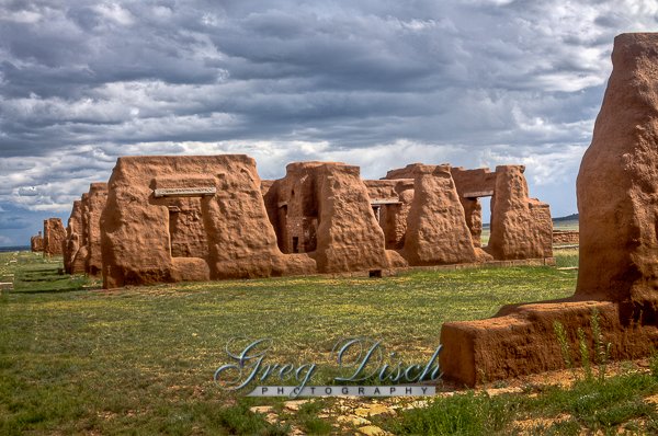
Fort Union National Monument Fort Union was established in 1851 as a guardian and protector of the Santa Fe Trail. During it’s forty-year history, three different forts were constructed close together. The third and final Fort Union was the largest in the American Southwest, and functioned as a military garrison, territorial arsenal, and military supply depot for the southwest. The site preserves the second of three forts constructed on the site beginning in 1851, as well as the ruins of the third. Also visible is a network of ruts from the Mountain and Cimarron Branches of the old Santa Fe Trail. Take the self-guided walking tour complete with push-button narrations at each stop to learn about life at this frontier outpost during the early days of American settlement of the West. As a key stopover point for travelers along the Old Santa Fe Trail, Fort Union was witness to countless expeditions, Indian raids, and commercial gatherings during its short but storied existence. Cost: Entrance Fees – Individuals 16 years of age and older $3.00 for 7  Days. Details – entrance fee also valid for 7 day use at Pecos National Historical Park Best Time to Visit: Anytime would be good to visit.Open daily except  Thanksgiving Day, Christmas Day, and New Year’s Day.Winter Hours: Labor Day to Memorial Day 8:00 a.m. to 4:00 p.m. Summer Hours: Memorial Day to Labor Day 8:00 a.m. to 6:00 p.m. Where it is: Fort Union National Monument is located north of Watrous, Mora County, New Mexico, USA. Directions: From Albuquerque (156 miles), Santa Fe (94 miles) or Las Vegas, NM (28 miles) take I-25 north, exit 366 at Watrous, 8 miles on NM 161.From Denver (313 miles), Colorado Springs (243 miles) or Raton (95 miles) take I-25 south, exit 366 at Watrous, 8 miles on NM 161. Map: Click here for a  map of Fort Union Links: National Park Service Web Site Contact: Fort Union National Monument P.O. Box 127 Watrous, NM Phone: (505) 425-8025 www.nps.gov/foun/ Tips for the Photographer Equipment: Any camera or equipment will work well to photograph the fort.  The trails and open setting allow shooting from about any distance. What to Photograph: The ruins of the old fort order ambien no rx buildings, but also the open meadow in which the fort is located.  Something that is quite rare to find these days is a historic subject that is not surrounded by modern buildings, power lines and other distractions.  At Fort Union you can shoot almost any direction and have nothing but nature in the background of your photo. Photography Tips: Shooting a location like this is going to depend upon the weather, more important is the sky.  If you have a lot in interesting clouds in the sky including a lot of sky will improve your photos.  If however you have only a clear blue or worse gray sky you will want to keep it to a minimum in your photos.For a better composition, try not to have the horizon across the middle of your photo.  Keep the horizon low in the photo if you have great sky, for at the top of the photo if you have poor sky, showing more of the grassland around the fort. Fort Union Photo Gallery Click Here for full page gallery More Photographic Destinations in New Mexico: Interactive Google Map Use the map  + – controls to zoom in and out, use the Map drop-down to change to “Map”, “Satellite”, “Hybrid”, or “Terrain” views.  Drag the little man icon from the upper left corner to a map location for street level view. Click on a pushpin for more information about the Photographic Destination, then click on the title to go to the location page. Click Here for Photographic Destinations by State   All the information in this post was believed to be accurate at the time it was published.  Please be sure to double check with the location before relying on this information as everything changes over time, especially hours, prices, and whether the location is still open.   Great Places for Great Photos   Let me help you to find a great location for your next photography adventure.  I will list many lesser-known destinations, as well as the famous "Icon Locations" for photography.  I will provide photos (Lots of Photos), location information, consisting of what there is to photograph as well as other information about the destination.  I will give costs, maps, directions, contact information, and other essential information for a successful photo trip.  I will only post for locations that I have personally photographed to ensure a quality guide to great locations for photography. If you know of great places that are not posted, please send me the details, I may just decide that is a place I need to go!     Greg Disch is a freelance photographer located in Arkansas. Greg specializes in nature, scenic, wildlife, and other outdoor subjects in Arkansas and other areas of the country.  Most of the images on this site are available for sale as prints, personal use, or rights managed stock photos. Greg offers both classroom instruction and in the field hands on photographic workshops. Classroom sessions are normally held in Fort Smith Arkansas, but arrangements can be made to bring a class to your group. All classes and workshops have small class sizes designed to provide an optimum student to instructor ratio, where you can get the personal attention, you need.  Most classes and workshops are limited to a maximum of six participants and will be held with a minimum of only two. If you are looking for a wonderful opportunity to get personal individual instruction, I do private workshops and classes at a location of your choice, whether doing a location photo shoot, coming to your home or business, traveling across the country on a road trip, or at my classroom.  This is a fantastic way to learn digital workflow and be sure that your computer equipment is properly configured for optimum performance. [...]Read more...
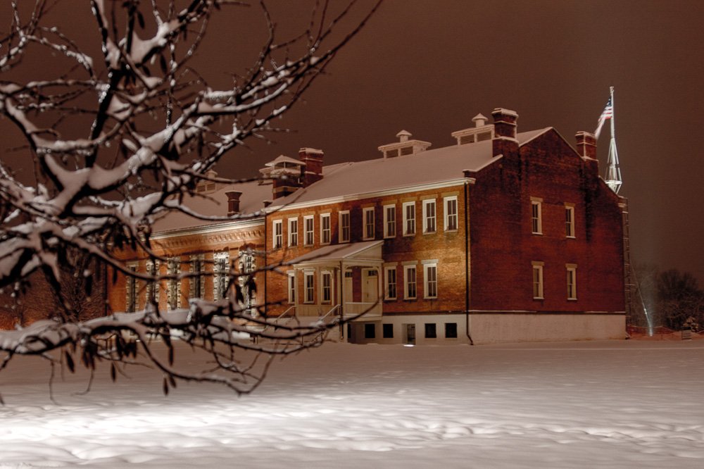
At Fort Smith National Historic Site you can walk where soldiers drilled, pause along the Trail of Tears, and stand where justice was served. The park includes the remains of two frontier forts and the Federal Court for the Western District of Arkansas.  Judge Isaac C. Parker, known as the “hanging judge,” presided over the court for 21 years. What to Photograph: Barracks/courthouse/jail building, the site of the first fort, the courtroom of judge Parker and of course the gallows. The fort was built at Belle Point overlooking the confluence of the Arkansas and Poteau Rivers and looks much the same as it did 100years ago.  The 37 star Garrison flag atop a 100′ flag pole, in the Parade ground where for more than 30 years, during the mid 1800’s soldiers drilled.  A recent addition to the site was the aquistion of the Frisco Station Depot, which is currently housing the Offices for the United States Mashal Museum, which will be building a new facility nearby in the near future.  There are exhibits in the vistor center which focus on Fort Smith’s milatary history. Visitors touring these buildings can see Judge Parker’s restored courtroom, the “Hell on the Border” jail, a partial reconstruction of the 1888s jail cells, as well as exhibits and videos on military history, Native Americans, the Trail of Tears, the operation of the federal court and its impact on Indian Territory, and U.S. Deputy Marshals and outlaws. Best Time for Photographers: Most anytime, is a good time to photograph here, you can shoot during all seasons and the site grounds are open at night for those interested in night photography. The Visitors’ Center is open daily, 9:00 a.m. to 5:00 p.m. and is scheduled to be closed only on December 25 and January 1.  The Park’s Grounds are open 24/7/365 and include the paved Rivertrail, parking lots, picnic tables, and some outdoor exhibits. Where it is: Downtown Fort Smith, Arkansas along the Arkansas River. Directions: From downtown Fort Smith on Rogers or Garrison Ave turn south at 4th St. Turn right onto Garland Ave. At the end of the next block is the entrance to the main parking lot. Parking is also available on Third Street. Maps: Click on map to enlarge Interactive Google Map Use the map  + – controls to zoom in and out, click and drag the to move the map, use the Map drop-down to change to “Map”, “Satellite”, “Hybrid”, or “Terrain” views.  Drag the little man icon from the upper left corner to a map location for street level view. Cost: Entrance Fees Individual (16 and Above) $4.00 (7 day pass)Individuals aged 16 and above are charged a $4.00 fee. Entrance fee is good for individual entrance into the exhibits inside the Barracks / Courthouse building.Other National Park passes are accepted. You can walk around on the grounds without paying the entrance fee, it is only collected for the inside exhibits. Links: Fort Smith National Historic Site Fort Smith Convention and Visitor’s Bureau Fort Smith Chamber of Commerce City of Fort Smith Location Contact Information: Fort Smith National Historic Site PO Box 1406 Fort Smith, AR 72902 E-mail Us Phone: Visitor Center and offices (479) 783-3961 Fax  (479) 783-5307 Nearest City or Town: Fort Smith,  Arkansas Facilities: Fort Smith is the second-largest city in Arkansas.  With an estimated population of 85,544 in 2009, it is the principal city of the Fort Smith, Arkansas-Oklahoma Metropolitan Statistical Area, a region of 293,063 residents which encompasses the Arkansas counties of Crawford, Franklin, and Sebastian, and the Oklahoma counties Le Flore and Sequoyah. Tips for the Photographer: Equipment: You do not need a great deal of equipment to photograph the National Historic Site, most things can be shot with a standard lens.  A flash will be necessary if you want to shoot inside the buildings. Photography Tips: There is a great veriety of subject matter to photograph and most any style and type of photography can be done at the Historic Site.  If you are shooting outdoors you will want a polarizing filter to enhance the blue skies.  Try and find interesting angles and be sure to watch your backgrounds, you are in downtown Fort Smith. Fort Smith National Historic Site Photo Gallery Click Here for full page gallery More Photographic Destinations in Arkansas: Interactive Google Map Use the map  + – controls to zoom in and out, use the Map drop-down to change to “Map”, “Satellite”, “Hybrid”, or “Terrain” views.  Drag the little man icon from the upper left corner to a map location for street level view. Click on a pushpin for more information about the Photographic Destination, then click on the title to go to the location page. Click Here for Photographic Destinations by State   All the information in this post was believed to be accurate at the time it was published.  Please be sure to double check with the location before relying on this information as everything changes over time, especially hours, prices, and whether the location is still open.   Great Places for Great Photos   Let me help you to find a great location for your next photography adventure.  I will list many lesser-known destinations, as well as the famous "Icon Locations" for photography.  I will provide photos (Lots of Photos), location information, consisting of what there is to photograph as well as other information about the destination.  I will give costs, maps, directions, contact information, and other essential information for a successful photo trip.  I will only post for locations that I have personally photographed to ensure a quality guide to great locations for photography. If you know of great places that are not posted, please send me the details, I may just decide that is a place I need to go!     Greg Disch is a freelance photographer located in Arkansas. Greg specializes in nature, scenic, wildlife, and other outdoor subjects in Arkansas and other areas of the country.  Most of the images on this site are available for sale as prints, personal use, or rights managed stock photos. Greg offers both classroom instruction and in the field hands on photographic workshops. Classroom sessions are normally held in Fort Smith Arkansas, but arrangements can be made to bring a class to your group. All classes and workshops have small class sizes designed to provide an optimum student to instructor ratio, where you can get the personal attention, you need.  Most classes and workshops are limited to a maximum of six participants and will be held with a minimum of only two. If you are looking for a wonderful opportunity to get personal individual instruction, I do private workshops and classes at a location of your choice, whether doing a location photo shoot, coming to your home or business, traveling across the country on a road trip, or at my classroom.  This is a fantastic way to learn digital workflow and be sure that your computer equipment is properly configured for optimum performance. [...]Read more...
Fort Scott National Historic Site Fort Scott National Historic Site is a historical area under the control of the United States National Park Service in Fort Scott Kansas. Named after General Winfield Scott, who achieved renown during the Mexican–American War, during the middle of the 19th century the fort served as a military base for US Army action in what was the edge of settlement in 1850. For the next quarter century, it was used as a supply base and to provide security in turbulent areas during the opening of the West to settlement, a period which included Bleeding Kansas and the American Civil War. The current national historic site protects 20 historic structures, a parade ground, and five acres of restored tallgrass prairie, inside the city of Fort Scott. With the Act of August 31, 1965, the National Park Service gave the city government of Fort Scott, Kansas the necessary funds and technical knowledge to restore the fort. On October 19, 1978, Fort Scott became a National Historic Site under the supervision of the National Park Service, encompassing 17 acres.  Surviving structures include four officers’ barracks, one dragoon’s barracks, two infantry barracks, a hospital, guardhouse, dragoon stables, ordnance and post headquarters, quartermaster stables, bake shop, flagpole, and magazine. Another feature of the park is 5 acres  of tallgrass prairie restored as part of an ecology-restoration project. What to Photograph: The historic structures of the fort, and the surrounding tall grass prairie. Where it is: Fort Scott National Historic Site is located in downtown Fort Scott, Kansas. U.S. Highways 69 and 54 intersect here. Fort Scott is about 90 miles south of Kansas City and 60 miles northwest of Joplin, Missouri. It is 4 miles from the Kansas-Missouri border. Signs directing visitors to Fort Scott are posted on highway 69 for visitors coming from the north and the south and on highway 54 for visitors coming from the east and the west. Highway 69 between Fort Scott and Kansas City is a four lane highway, The entrance to the site is one block west of the intersection of Highway 69 and Highway 54 east. (Highway 54 west splits off from Highway 69 about 1/2 mile north of town.) Maps: Interactive Google Map Use the map  + – controls to zoom in and out, click and drag the to move the map, use the Map drop-down to change to “Map”, “Satellite”, “Hybrid”, or “Terrain” views.  Drag the little man icon from the upper left corner to a map location for street level view. Cost: Entrance to Fort Scott NHS is free of charge. It is open 362 days a year (closed Thanksgiving, Christmas, and New Year’s Day. Hours: Today the fort is open throughout the year, save for Thanksgiving, Christmas, and New Years Day. All Park – Fort Scott National Historic Site Visitors may walk the grounds from sunrise to sunset except during periods of snow, ice or other inclement weather conditions that make the grounds unsafe Standard Hours Sunday 8:00 AM – 5:00 PM Monday 8:00 AM – 5:00 PM Tuesday 8:00 AM – 5:00 PM Wednesday 8:00 AM – 5:00 PM Thursday 8:00 AM – 5:00 PM Friday 8:00 AM – 5:00 PM Saturday 8:00 AM – 5:00 PM The visitor center is open seven days a week. Summer hours are 8:00 a.m.-5:00 p.m. April 1 through October 31. Winter hours are 8:30 a.m. to 4:30 p.m. November 1 through March 31. Facilities: The visitor center includes a park store, restrooms and orientation desk. The site is located in downtown Fort Scott Kansas. Links: Fort Scott National Historic Site NPS NPS Fort Scott Mobile App Location Contact Information: Physical Address Fort Scott NHS Old Fort Blvd. Fort Scott, KS 66701 By Mail P.O. Box 918 Fort Scott, KS 66701-0918 By Phone Visitor Information 620-223-0310 By Fax 620-223-0188 Fort Scott National Historic Site Photo Gallery Click Here for full page gallery More Photographic Destinations in Kansas: Interactive Google Map Use the map  + – controls to zoom in and out, use the Map drop-down to change to “Map”, “Satellite”, “Hybrid”, or “Terrain” views.  Drag the little man icon from the upper left corner to a map location for street level view. Click on a pushpin for more information about the Photographic Destination, then click on the title to go to the location page. Click Here for Photographic Destinations by State    All the information in this post was believed to be accurate at the time it was published.  Please be sure to double check with the location before relying on this information as everything changes over time, especially hours, prices, and whether the location is still open.   Great Places for Great Photos   Let me help you to find a great location for your next photography adventure.  I will list many lesser-known destinations, as well as the famous "Icon Locations" for photography.  I will provide photos (Lots of Photos), location information, consisting of what there is to photograph as well as other information about the destination.  I will give costs, maps, directions, contact information, and other essential information for a successful photo trip.  I will only post for locations that I have personally photographed to ensure a quality guide to great locations for photography. If you know of great places that are not posted, please send me the details, I may just decide that is a place I need to go!     Greg Disch is a freelance photographer located in Arkansas. Greg specializes in nature, scenic, wildlife, and other outdoor subjects in Arkansas and other areas of the country.  Most of the images on this site are available for sale as prints, personal use, or rights managed stock photos. Greg offers both classroom instruction and in the field hands on photographic workshops. Classroom sessions are normally held in Fort Smith Arkansas, but arrangements can be made to bring a class to your group. All classes and workshops have small class sizes designed to provide an optimum student to instructor ratio, where you can get the personal attention, you need.  Most classes and workshops are limited to a maximum of six participants and will be held with a minimum of only two. If you are looking for a wonderful opportunity to get personal individual instruction, I do private workshops and classes at a location of your choice, whether doing a location photo shoot, coming to your home or business, traveling across the country on a road trip, or at my classroom.  This is a fantastic way to learn digital workflow and be sure that your computer equipment is properly configured for optimum performance. [...]Read more...
Fort Pickens Fort Pickens is a pentagonal historic United States military fort on Santa Rosa Island in the Pensacola, Florida, area. It is named after American Revolutionary War hero Andrew Pickens. The fort was completed in 1834 and remained in use until 1947. Fort Pickens is included within the Gulf Islands National Seashore, and as such, is administered by the National Park Service. After the War of 1812, the United States decided to fortify all of its major ports. French engineer Simon Bernard was appointed to design Fort Pickens. Construction lasted from 1829 to 1834, with 21.5 million bricks being used to build it. Much of the construction was done by slaves. Its construction was supervised by Colonel William H. Chase of the U.S. Army Corps of Engineers. During the American Civil War, he sided with the Confederacy and was appointed to command Florida’s troops. With its completion, Fort Pickens became the largest brick structure on the Gulf of Mexico. It exhibited the latest technologies in coastal defense design, construction, and weaponry. Fort Pickens was a mark of the growing power of the United States, and as a part of the Third System, it helped make America virtually impregnable, for a time. What to Photograph: There is still a great deal of the old fort that is intact and open to the public and makes an excellent photographic subject.  In addition is the beach and Gulf of Mexico on one side and Pensacola bay on the other.  There are a large number of Osprey nesting and in the morning and evening can be seen eating fish in the trees. Where it is: From I-10, take I-110 S to Pensacola. Take U.S. Highway 98S/FL Highway 30 over Pensacola Bay to Gulf Breeze. Follow 98 through Gulf Breeze, turn right onto FL Highway 399 to Pensacola Beach. Pay $1/vehicle at toll booth entering Pensacola Beach, then turn right at the traffic light onto Fort Pickens Road. It is about 3 miles to the park entrance station. Maps: Interactive Google Map Use the map  + – controls to zoom in and out, click and drag the to move the map, use the Map drop-down to change to “Map”, “Satellite”, “Hybrid”, or “Terrain” views.  Drag the little man icon from the upper left corner to a map location for street level view. Cost: Per person (pedestrian, cyclist, etc.)………………………..$10 Motorcycle…………………………………………………………..$15 Private vehicle (capacity <15)…………………………………$20 Private vehicle (capacity >15)……$7 per person; up to $25 Commercial Groups Per vehicle (capacity 6 or less)….$25 plus; $10 per person Per vehicle (capacity 7 to 25)………………………………….$40 Commercial Bus (capacity 26 or more)…………………..$100  Interagency passes waive all entrance fees. Hours: March 1 – October 31: 5:00 a.m. to 9:00 p.m. (last entry at 8:00 p.m.) November 1 – February 28: 5:00 a.m. to 6:00 p.m. Year-round: Historic Fort: 8:00 a.m. to sunset Bookstore & Discovery Center: 9:00 a.m. to 4:30 p.m. Campground Registration Office: 9:00 a.m. to 4:30 p.m. Facilities: Fort Pickens Campground This large campground is open for reservations year-round. It contains 180 family sites with electric and water hookups. A group site with water hookup is also available. Amenities include flush toilets, showers, drinking water and a dump station. There are no boat ramps in the Fort Pickens area. Links: Location Contact Information: Gulf Islands National Seashore 1801 Gulf Breeze Parkway  Gulf Breeze, FL 32563 Phone: (850) 934-2600 Fort Pickens Photo Gallery Click Here for full page gallery More Photographic Destinations in Florida: Interactive Google Map Use the map  + – controls to zoom in and out, use the Map drop-down to change to “Map”, “Satellite”, “Hybrid”, or “Terrain” views.  Drag the little man icon from the upper left corner to a map location for street level view. Click on a pushpin for more information about the Photographic Destination, then click on the title to go to the location page. Click Here for Photographic Destinations by State   All the information in this post was believed to be accurate at the time it was published.  Please be sure to double check with the location before relying on this information as everything changes over time, especially hours, prices, and whether the location is still open.   Great Places for Great Photos   Let me help you to find a great location for your next photography adventure.  I will list many lesser-known destinations, as well as the famous "Icon Locations" for photography.  I will provide photos (Lots of Photos), location information, consisting of what there is to photograph as well as other information about the destination.  I will give costs, maps, directions, contact information, and other essential information for a successful photo trip.  I will only post for locations that I have personally photographed to ensure a quality guide to great locations for photography. If you know of great places that are not posted, please send me the details, I may just decide that is a place I need to go!     Greg Disch is a freelance photographer located in Arkansas. Greg specializes in nature, scenic, wildlife, and other outdoor subjects in Arkansas and other areas of the country.  Most of the images on this site are available for sale as prints, personal use, or rights managed stock photos. Greg offers both classroom instruction and in the field hands on photographic workshops. Classroom sessions are normally held in Fort Smith Arkansas, but arrangements can be made to bring a class to your group. All classes and workshops have small class sizes designed to provide an optimum student to instructor ratio, where you can get the personal attention, you need.  Most classes and workshops are limited to a maximum of six participants and will be held with a minimum of only two. If you are looking for a wonderful opportunity to get personal individual instruction, I do private workshops and classes at a location of your choice, whether doing a location photo shoot, coming to your home or business, traveling across the country on a road trip, or at my classroom.  This is a fantastic way to learn digital workflow and be sure that your computer equipment is properly configured for optimum performance. [...]Read more...
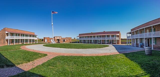
    Fort Morgan Fort Morgan is a historic masonry Pentagonal bastion fort at the mouth of Mobile Bay, Alabama, United States. Named for Revolutionary War hero Daniel Morgan, it was built on the site of the earlier Fort Bowyer, an earthen and stockade type fortification involved in the final land battles of the War of 1812. Skilled masons, many of which were enslaved African Americans, built the fortification which contains more than 46 million cubic yards of bricks. Construction was completed in 1834 and it received its first garrison in March of the same year.Used intermittently through the Spanish American War, World War I and World War II, the site showcases the evolution of seacoast fortifications and adaptations made by the U.S. Army for the defense of the country. In 1946 the site was turned over to the State of Alabama as a historic site. Fort Morgan was designated a National Historic Landmark in 1960. In 2007 it was listed as “one of the nation’s 10 most endangered battle sites” by the Civil War Preservation Trust in History Under Siege: A Guide to America’s Most Endangered Civil War Battlefields. In June 2008, a 90-pound live Union naval shell was uncovered at the site. The shell was from a Parrott rifle on a U.S. Navy warship and was fired at the fort in the summer of 1864. The discovery came during excavations as part of a project meant to repair cracks in the walls. Where it is: Fort Morgan is at the western end of Hwy 180, 22 miles west of Hwy 59 in Gulf Shores. You can reach the site from Dauphin Island by riding the Mobile Bay Ferry. Get directions on Google Maps Maps: Interactive Google Map Use the map  + – controls to zoom in and out, click and drag the to move the map, use the Map drop-down to change to “Map”, “Satellite”, “Hybrid”, or “Terrain” views.  Drag the little man icon from the upper left corner to a map location for street level view. Satellite View of Fort Morgan GPS: 30°13’43.35″ N 88°1’22.47″ W   Cost:  ADULT $7 * SENIOR OVER 65  $5 * STUDENT OVER 12 $5 * CHILD 6-12 $4 * UNDER 6 FREE Hours: GROUNDS, BEACH, AND FISHING — 8:00AM TO 5:00PM DAILY MUSEUM/GIFT SHOP 251-540-7127 — 9:00AM TO 4:30PM DAILY ADMINISTRATION OFFICE 251-540-5257– 8:00AM TO 5:00PM MON. thru FRI. CLOSED THANKSGIVING DAY, CHRISTMAS DAY, AND NEW YEARS DAY (GATES ARE LOCKED AT 5 PM) Facilities: Museum, restroom, seasonal snack bar. Location Contact Information: Site Director: Heather Tassin Museum: 251-540-5257 Email: heathertassin@fort-morgan.org Media Contact: Jacqulyn Kirkland, 334-230-2645, jacqulyn.kirkland@ahc.alabama.gov 51 Hwy 180 West, Gulf Shores, Alabama 36542   Fort Morgan Photo Gallery   Click Here for full page gallery More Photographic Destinations in Alabama: Interactive Google Map Use the map  + – controls to zoom in and out, use the Map drop-down to change to “Map”, “Satellite”, “Hybrid”, or “Terrain” views.  Drag the little man icon from the upper left corner to a map location for street level view. Click on a pushpin for more information about the Photographic Destination, then click on the title to go to the location page. Click Here for Photographic Destinations by State All the information in this post was believed to be accurate at the time it was published.  Please be sure to double check with the location before relying on this information as everything changes over time, especially hours, prices, and whether the location is still open.   Great Places for Great Photos   Let me help you to find a great location for your next photography adventure.  I will list many lesser-known destinations, as well as the famous "Icon Locations" for photography.  I will provide photos (Lots of Photos), location information, consisting of what there is to photograph as well as other information about the destination.  I will give costs, maps, directions, contact information, and other essential information for a successful photo trip.  I will only post for locations that I have personally photographed to ensure a quality guide to great locations for photography. If you know of great places that are not posted, please send me the details, I may just decide that is a place I need to go!     Greg Disch is a freelance photographer located in Arkansas. Greg specializes in nature, scenic, wildlife, and other outdoor subjects in Arkansas and other areas of the country.  Most of the images on this site are available for sale as prints, personal use, or rights managed stock photos. Greg offers both classroom instruction and in the field hands on photographic workshops. Classroom sessions are normally held in Fort Smith Arkansas, but arrangements can be made to bring a class to your group. All classes and workshops have small class sizes designed to provide an optimum student to instructor ratio, where you can get the personal attention, you need.  Most classes and workshops are limited to a maximum of six participants and will be held with a minimum of only two. If you are looking for a wonderful opportunity to get personal individual instruction, I do private workshops and classes at a location of your choice, whether doing a location photo shoot, coming to your home or business, traveling across the country on a road trip, or at my classroom.  This is a fantastic way to learn digital workflow and be sure that your computer equipment is properly configured for optimum performance. [...]Read more...
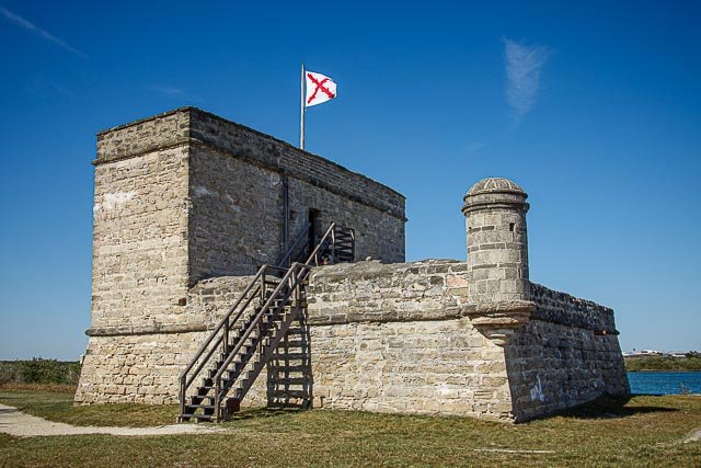
Fort Mantanzas National Monument Fort Matanzas National Monument was designated a United States National Monument on October 15, 1924. The monument consists of a 1740 Spanish fort called Fort Matanzas, and about 100 acres of salt marsh and barrier islands along the Matanzas River on the northern Atlantic coast of Florida. It is operated by the National Park Service in conjunction with the Castillo de San Marcos National Monument in the city of St. Augustine. Fort Matanzas was built by the Spanish in 1742 to guard Matanzas Inlet, the southern mouth of the Matanzas River, which could be used as a rear entrance to the city of St. Augustine. Such an approach avoided St. Augustine’s primary defense system, centered at Castillo de San Marcos. In 1740, Gov. James Oglethorpe of Georgia used the inlet to blockade St. Augustine and launch a thirty-nine-day siege. St. Augustine endured the siege, but the episode convinced the Spanish that protecting the inlet was necessary to the security of the town. Under Gov. Manuel de Montiano’s orders, construction of the fort began that year and was completed in 1742. Engineer Pedro Ruiz de Olano, who had worked on additions to the Castillo de San Marcos, designed the fortified observation tower. Convicts, slaves, and troops from Cuba were used as labor to erect the structure, which was sited on present-day Rattlesnake Island and had a commanding position over Matanzas Inlet. Where it is: Fort Matanzas National Monument is located about 14 miles south of the historic district of St. Augustine, Florida. St. Augustine is located on Florida’s Northeastern Atlantic coast about midway between Jacksonville and Daytona Beach. They physical address is 8635 A1A South, St. Augustine, FL 32080. From I-95: Take exit 305 (Route 206). Follow Route 206 east about 6 miles to Highway A1A. Turn right and follow A1A south for 4 miles to the park entrance on the right side of the road. From St. Augustine: Follow Highway A1A south for approximately 14 miles to the park entrance on the right side of the road. From Daytona Beach via A1A: Follow Highway A1A about 40 miles north. The park entrance is on the left about 1/2 mile north of the Matanzas Inlet bridge. GPS: 29°42’55.2114″ N 81°14’22.2303″ W Maps: Interactive Google Map Use the map  + – controls to zoom in and out, click and drag the to move the map, use the Map drop-down to change to “Map”, “Satellite”, “Hybrid”, or “Terrain” views.  Drag the little man icon from the upper left corner to a map location for street level view. Hours: Fort Matanzas National Monument is open to the public from 9:00 AM to 5:30 PM every day of the year except Thanksgiving Day (fourth Thursday in November) and Christmas Day (December 25). Boarding Passes are required to ride the ferry. They are issued for free in the Fort Matanzas Visitor Center (NOT the St. Augustine city Visitor Center) Ferry times: The ferry to the fort carries 35 people on a first come, first served basis and leaves the Visitor Center dock at the following times, weather permitting*: 9:30 am 1:30 pm 10:30 am 2:30 pm 11:30 am 3:30 pm 12:30 pm 4:30pm Everyone riding the ferry needs a pass, including babies and children. Cost: Boarding Pass – There are no fees to enter the park or to take the ferry to the fort. The 36-passenger ferry operates with a Boarding Pass system. The passes are issued from the Fort Matanzas Visitor Center (not the St. Augustine city Visitor Center) on a first come, first served basis. Family members of all ages must have a pass to board the ferry. Location Contact Information: Mailing Address: 8635 A1A South St Augustine, FL 32080 Phone Numbers: Headquarters (Castillo de San Marcos and Fort Matanzas National Monuments): 904-829-6506, x227 Fort Matanzas Visitor Center and Office: 904-471-0116 Fax: 904-471-7605 E-mail: Click here to send an electronic message   Facilities: There is a Visitor Center and restrooms on the site.Eastern National operates a book and gift store inside the Visitor Center. Fort Mantanzas National Monument Photo Gallery Click Here for full page gallery   More Photographic Destinations in Florida Interactive Google Map Use the map  + – controls to zoom in and out, use the Map drop-down to change to “Map”, “Satellite”, “Hybrid”, or “Terrain” views.  Drag the little man icon from the upper left corner to a map location for street level view. Click on a pushpin for more information about the Photographic Destination, then click on the title to go to the location page. Click Here for Photographic Destinations by State    All the information in this post was believed to be accurate at the time it was published.  Please be sure to double check with the location before relying on this information as everything changes over time, especially hours, prices, and whether the location is still open.   Great Places for Great Photos   Let me help you to find a great location for your next photography adventure.  I will list many lesser-known destinations, as well as the famous "Icon Locations" for photography.  I will provide photos (Lots of Photos), location information, consisting of what there is to photograph as well as other information about the destination.  I will give costs, maps, directions, contact information, and other essential information for a successful photo trip.  I will only post for locations that I have personally photographed to ensure a quality guide to great locations for photography. If you know of great places that are not posted, please send me the details, I may just decide that is a place I need to go!     Greg Disch is a freelance photographer located in Arkansas. Greg specializes in nature, scenic, wildlife, and other outdoor subjects in Arkansas and other areas of the country.  Most of the images on this site are available for sale as prints, personal use, or rights managed stock photos. Greg offers both classroom instruction and in the field hands on photographic workshops. Classroom sessions are normally held in Fort Smith Arkansas, but arrangements can be made to bring a class to your group. All classes and workshops have small class sizes designed to provide an optimum student to instructor ratio, where you can get the personal attention, you need.  Most classes and workshops are limited to a maximum of six participants and will be held with a minimum of only two. If you are looking for a wonderful opportunity to get personal individual instruction, I do private workshops and classes at a location of your choice, whether doing a location photo shoot, coming to your home or business, traveling across the country on a road trip, or at my classroom.  This is a fantastic way to learn digital workflow and be sure that your computer equipment is properly configured for optimum performance. [...]Read more...
Fort Leaton State Historic Site Fort Leaton is believed to have been built as an adobe residence in the 1830s by Juan Bustillos. In 1848, it was acquired by Benjamin Leaton, who lived in the structure and also used it as his trading post and fortress. Benjamin Leaton was a trader, freight hauler along the Chihuahua Trail, and a bounty hunter paid by various local governments in Mexico for each scalp taken from an indigenous person. He also traded munitions to the Apache and Comanche for any stolen cattle they brought him. When Presidio County was established in 1850, Fort Leaton was its first seat of government. Leaton died in 1851, and his widow married Edward Hall who continued operating the freight business from the fort. Hall became financially indebted to Leaton’s scalp hunting partner John Burgess. Hall defaulted on his debt to Burgess in 1864, and was murdered. Burgess took over the fort, and was in turn murdered by Leaton’s son in 1875. The Burgess family remained in the fort until they abandoned it in 1926. The fort was purchased by Marfa State Bank and a private citizen in the 1930s and donated to Presidio County. An attempt at restoration was begun, but adequate financing never materialized. The site was then purchased by a private citizen and donated to the state of Texas. In 1968, the site was designated Fort Leaton State Historic Site. It opened to the public in 1978. Because of its desolate location and the constant threat of Indian attack, Fort Leaton offered much-needed frontier defense. The private bastion was the only fortification on the American side of the Rio Grande between Eagle Pass and El Paso before and during the building of Fort Davis (Jeff Davis County), and the United States Army made Fort Leaton its unofficial headquarters. Even after the completion of Fort Davis, eighty miles to the north, the army used the private fort as an outpost for military patrols. Military maps of the 1850s listed Fort Leaton along with official army posts. Fort Leaton was added to the National Register of Historic Places listings in Presidio County, Texas on June 18, 1973. The park is day use only and offers picnicking areas, guided tours, plus exhibits on the history from 15th century, natural history, and archaeological history of the area. The site serves for historical study activities. What to Photograph The restored Fort Leaton with many of the furnishings of the time.  Situated in the Chihuahuan Desert, plants range from arid-adapted cacti to water-loving cottonwoods. Where it is: The park is located four miles southeast of Presidio on the River Road to the Big Bend (FM 170), one of the most scenic highway routes in the southeast. Maps: Interactive Google Map Use the map  + – controls to zoom in and out, click and drag the to move the map, use the Map drop-down to change to “Map”, “Satellite”, “Hybrid”, or “Terrain” views.  Drag the little man icon from the upper left corner to a map location for street level view. GPS: Latitude: 29.542511 Longitude: -104.326348 Links: Interpretive Guide to Fort Leaton State Historic Site (PDF) Fort Leaton State Historic Site Self-Guided Walking Tour (PDF) Cost: Entrance Fees 13 years and older: $5 Daily Child 12 Years and Under : Free Hours: Hours 8 a.m. to 4:30 p.m. Busy Season September through April Facilities: There is a picnic area and public restrooms. The Texas State Park Store gift shop is located on the grounds. The Barton Warnock Environmental Education Center serves as the visitor center for both Ft. Leaton State Historic Site and Big Bend Ranch State Park. Wireless Internet Access (Wi-Fi) is available in some areas of this site. Location Contact Information: Location: FM 170 E. Presidio, TX 79845 Mailing: P.O. Box 2349 Presidio, TX 79845 (432) 229-3613 Fort Leaton Photo Gallery Click Here for full page gallery   More Photographic Destinations in Texas: Interactive Google Map Use the map  + – controls to zoom in and out, use the Map drop-down to change to “Map”, “Satellite”, “Hybrid”, or “Terrain” views.  Drag the little man icon from the upper left corner to a map location for street level view. Click on a pushpin for more information about the Photographic Destination, then click on the title to go to the location page. Click Here for Photographic Destinations by State    All the information in this post was believed to be accurate at the time it was published.  Please be sure to double check with the location before relying on this information as everything changes over time, especially hours, prices, and whether the location is still open.   Great Places for Great Photos   Let me help you to find a great location for your next photography adventure.  I will list many lesser-known destinations, as well as the famous "Icon Locations" for photography.  I will provide photos (Lots of Photos), location information, consisting of what there is to photograph as well as other information about the destination.  I will give costs, maps, directions, contact information, and other essential information for a successful photo trip.  I will only post for locations that I have personally photographed to ensure a quality guide to great locations for photography. If you know of great places that are not posted, please send me the details, I may just decide that is a place I need to go!     Greg Disch is a freelance photographer located in Arkansas. Greg specializes in nature, scenic, wildlife, and other outdoor subjects in Arkansas and other areas of the country.  Most of the images on this site are available for sale as prints, personal use, or rights managed stock photos. Greg offers both classroom instruction and in the field hands on photographic workshops. Classroom sessions are normally held in Fort Smith Arkansas, but arrangements can be made to bring a class to your group. All classes and workshops have small class sizes designed to provide an optimum student to instructor ratio, where you can get the personal attention, you need.  Most classes and workshops are limited to a maximum of six participants and will be held with a minimum of only two. If you are looking for a wonderful opportunity to get personal individual instruction, I do private workshops and classes at a location of your choice, whether doing a location photo shoot, coming to your home or business, traveling across the country on a road trip, or at my classroom.  This is a fantastic way to learn digital workflow and be sure that your computer equipment is properly configured for optimum performance. [...]Read more...
  Fort Larned National Historic Site Discover a complete and authentic army post from the 1860s -1870s! This well-preserved fort on the Santa Fe Trail shares a tumultuous history of the Indian Wars era. The sandstone constructed buildings sheltered troops who were known as the Guardians of the Santa Fe Trail. Fort Larned National Historic Site preserves Fort Larned which operated from 1859 to 1878. Renovations to Fort Larned took place between 1866 and 1868. The original sod and adobe structures were removed and replaced with the sandstone buildings that make up the fort today. The post was abandoned on July 13, 1878, and on March 26, 1883, the Fort Larned Military Reservation was transferred from the War Department to the General Land Office of the Department of the Interior. From 1885 to 1966, the buildings housed the headquarters of a ranch, with the owners living in the house of the commanding officer and the employees residing in what had been the officers’ quarters. In 1957 the Fort Larned Historical Society was founded to develop and open the site as a tourist attraction. The fort was designated as a National Landmark in 1961, and in 1964 it was incorporated as a unit of the National Park System. What to Photograph A complete and authentic 1860s army post. Where it is: Fort Larned National Historic Site is located on KS Hwy 156, six miles west of Larned, KS. From I-70 Westbound Take exit 225 for KS 156. Turn left and follow KS 156 approximately 82 miles to Fort Larned National Historic Site. From I-70 Eastbound Take exit 159 for US Hwy 183 south. Follow Hwy 183 about 49 miles south to KS 156. Turn left on KS 156 and continue about 5 miles to Fort Larned National Historic Site. From Dodge City Follow Hwy 56 to Hwy 183 north. Follow 183 north to KS 156. Turn right on KS 156 and continue 5 miles to Fort Larned NHS. From Wichita There are several possible routes. If you prefer major highways, follow Hwy 54 west of Wichita to Hwy 183 north in Greensburg, KS. Follow Hwy 183 north to KS 156. Turn right on KS 156 and continue 5 miles to Fort Larned NHS. If you prefer a shorter distance, follow KS 96 north from Wichita to US Hwy 50 west in Hutchinson. Follow US Hwy 50 west to KS 19. Follow KS 19 north into Larned. Turn left on KS 156 and continue 6 miles to Fort Larned NHS. Fort Larned’s parking lot is about a 1/4 mile from the park entrance. There is a section for both cars and buses and RVs. From the parking lot, it is a short walk across the river to the fort. Handicap parking is located by the walkway leading to the footbridge crossing the river. Maps: Interactive Google Map Use the map  + – controls to zoom in and out, click and drag the to move the map, use the Map drop-down to change to “Map”, “Satellite”, “Hybrid”, or “Terrain” views.  Drag the little man icon from the upper left corner to a map location for street level view. Links: National Park Service Site GPS: 38°10’57.318″ N 99°13’3″ W Hours: Staff begin closing the grounds and visitor center at 4:30 p.m. The parking lot gate is closed and locked for the night at 5 p.m. Standard Hours Sunday 8:30 AM – 4:30 PM Monday 8:30 AM – 4:30 PM Tuesday 8:30 AM – 4:30 PM Wednesday 8:30 AM – 4:30 PM Thursday 8:30 AM – 4:30 PM Friday 8:30 AM – 4:30 PM Saturday 8:30 AM – 4:30 PM Closed Thanksgiving, Christmas, and New Year’s Day.   Cost: There is no entrance fee or charge to visit. Facilities: Fort Larned Visitor Center Located in one of the two historic enlisted barracks, the park visitor center provides orientation to the grounds, a 10 minute AV program, and museum exhibits. Restrooms and drinking fountains are available in the visitor center and the picnic area. Location Contact Information: Mailing Address: 1767 KS Hwy 156 Larned, KS 67550 Phone: (620) 285-6911 This phone is answered during regular business hours. After hours calls will be answered the next day. Please select a mailbox or leave a message on the main extension when the fort is closed.   Fort Larned National Historic Site Photo Gallery Click Here for full page gallery   More Photographic Destinations in Kansas: Interactive Google Map Use the map  + – controls to zoom in and out, use the Map drop-down to change to “Map”, “Satellite”, “Hybrid”, or “Terrain” views.  Drag the little man icon from the upper left corner to a map location for street level view. Click on a pushpin for more information about the Photographic Destination, then click on the title to go to the location page. Click Here for Photographic Destinations by State    All the information in this post was believed to be accurate at the time it was published.  Please be sure to double check with the location before relying on this information as everything changes over time, especially hours, prices, and whether the location is still open.   Great Places for Great Photos   Let me help you to find a great location for your next photography adventure.  I will list many lesser-known destinations, as well as the famous "Icon Locations" for photography.  I will provide photos (Lots of Photos), location information, consisting of what there is to photograph as well as other information about the destination.  I will give costs, maps, directions, contact information, and other essential information for a successful photo trip.  I will only post for locations that I have personally photographed to ensure a quality guide to great locations for photography. If you know of great places that are not posted, please send me the details, I may just decide that is a place I need to go!     Greg Disch is a freelance photographer located in Arkansas. Greg specializes in nature, scenic, wildlife, and other outdoor subjects in Arkansas and other areas of the country.  Most of the images on this site are available for sale as prints, personal use, or rights managed stock photos. Greg offers both classroom instruction and in the field hands on photographic workshops. Classroom sessions are normally held in Fort Smith Arkansas, but arrangements can be made to bring a class to your group. All classes and workshops have small class sizes designed to provide an optimum student to instructor ratio, where you can get the personal attention, you need.  Most classes and workshops are limited to a maximum of six participants and will be held with a minimum of only two. If you are looking for a wonderful opportunity to get personal individual instruction, I do private workshops and classes at a location of your choice, whether doing a location photo shoot, coming to your home or business, traveling across the country on a road trip, or at my classroom.  This is a fantastic way to learn digital workflow and be sure that your computer equipment is properly configured for optimum performance. [...]Read more...
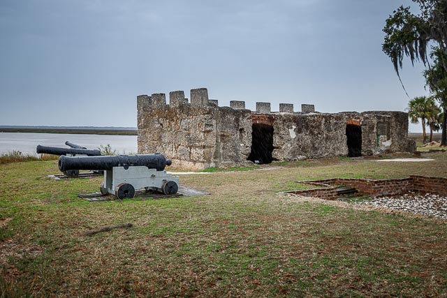
Fort Frederica Walk beneath moss-draped live oaks and use your imagination to travel back in time as you explore the archeological remains of Fort Frederica. Once a thriving British town and fort founded in 1736 by General James Edward Oglethorpe, Fort Frederica was designed to defend the northern colonies against Spanish attack. Fort Frederica National Monument, on St. Simons Island, Georgia, preserves the archaeological remnants of a fort and town built by James Oglethorpe between 1736 and 1748 to protect the southern boundary of the British colony of Georgia from Spanish raids. About 630 British troops were stationed at the fort. A town of up to 500 colonial residents had grown up outside the fort; it was laid out following principles of the Oglethorpe Plan for towns in the Georgia Colony. The town was named Frederica, after Frederick, Prince of Wales, son of King George II. The monument was listed on the National Register of Historic Places on October 15, 1966. In the 1742 battles of Bloody Marsh and Gully Hole Creek, forces under Oglethorpe successfully repulsed Spanish attempts to invade St. Simons Island. Afterward the Spanish no longer threatened the colony; in 1749 the government disbanded the garrison at Frederica. Soon the village fell into economic decline, and by 1755 it was mostly abandoned. The town survived a fire in 1758, but after a few more years, it was abandoned. Naturalist William Bartram visited the site in March, 1774. Though it was in ruins he noted that there was still a small garrison there. Fort Frederica was documented and authorized as a National Monument on May 26, 1936, under the Franklin D. Roosevelt administration during the Great Depression. During this period, the Works Progress Administration (WPA) sponsored numerous surveys of historic areas and buildings across the country to identify, document and protect the resources for the future, as well as to provide employment. Photography Information: Although there is not a lot left of the fort or the village the grounds contain some magnificent Live Oak trees draped with Spanish Moss that make for some great photos. Where it is: Fort Frederica is located on St. Simons Island the largest barrier island in the Golden Isles of Georgia. From I-95, heading North from Florida/Georgia border, take Exit 29. At end of ramp, turn right on Route 17 North. Follow Route 17 North, over the Sidney Lanier Bridge, to the intersection of F.J. Torras causeway. You will have to merge into the right hand turn lane before actually getting to the intersection. Take causeway over to Saint Simons Island. At end of causeway, get in left lane,and loop around, go to traffic light. Travel straight through light on Sea Island Road. Follow Sea Island Road to Frederica Road. At light, turn left onto Frederica. Follow Frederica to small traffic circle (roundabout). Take second exit at traffic circle (still on Frederica Road). Travel approximately 1 mile to entrance of park. It is on left, across the street from Wesley United Methodist Church. From I-95, heading South from Savannah/South Carolina, take Exit 38. At end of ramp, turn left onto Golden Isles Parkway/Spur 25. Follow Parkway to Route 17 South. Turn right onto Glynn Ave (Route 17) and get in left lane as soon as possible. Follow Route 17 to F.J. Torres Causeway intersection. Turn left at light. Take causeway over to Saint Simons Island. At end of causeway, get in left lane,and loop around, go to traffic light. Travel straight through light on Sea Island Road. Follow Sea Island Road to Frederica Road. At light, turn left onto Frederica. Follow Frederica to small traffic circle (roundabout). Take second exit at traffic circle (still on Frederica Road). Travel approximately 1 mile to entrance of park. It is on left, across the street from Wesley United Methodist Church. The Bloody Marsh unit of the park is located on Old Demere Road, near the Saint Simons Island airport. Maps: Interactive Google Map Use the map  + – controls to zoom in and out, click and drag the to move the map, use the Map drop-down to change to “Map”, “Satellite”, “Hybrid”, or “Terrain” views.  Drag the little man icon from the upper left corner to a map location for street level view. GPS: 31°13’23.868″ N 81°23’21.942″ W Cost: Fort Frederica National Monument is a fee-free park. There are no entrance or parking fees. Hours: Fort Frederica National Monument: The visitor center, restrooms,trails and park grounds are open from 9:00 am to 5:00 pm daily. The park is closed on the following holidays: Thanksgiving, Christmas Day and New Year’s Day Facilities: There is a visitor center with a gift shop and restrooms at the fort.  Food and lodging are available on St. Simons Island. Location Contact Information: Fort Frederica National Monument 6515 Frederica Rd. St. Simons Island, GA 31522 phone: 912-638-3639 fax: 912-634-5357 Fort Frederica Photo Gallery Click Here for full page gallery   More Photographic Destinations in Georgia: Interactive Google Map Use the map  + – controls to zoom in and out, use the Map drop-down to change to “Map”, “Satellite”, “Hybrid”, or “Terrain” views.  Drag the little man icon from the upper left corner to a map location for street level view. Click on a pushpin for more information about the Photographic Destination, then click on the title to go to the location page. Click Here for Photographic Destinations by State    All the information in this post was believed to be accurate at the time it was published.  Please be sure to double check with the location before relying on this information as everything changes over time, especially hours, prices, and whether the location is still open.   Great Places for Great Photos   Let me help you to find a great location for your next photography adventure.  I will list many lesser-known destinations, as well as the famous "Icon Locations" for photography.  I will provide photos (Lots of Photos), location information, consisting of what there is to photograph as well as other information about the destination.  I will give costs, maps, directions, contact information, and other essential information for a successful photo trip.  I will only post for locations that I have personally photographed to ensure a quality guide to great locations for photography. If you know of great places that are not posted, please send me the details, I may just decide that is a place I need to go!     Greg Disch is a freelance photographer located in Arkansas. Greg specializes in nature, scenic, wildlife, and other outdoor subjects in Arkansas and other areas of the country.  Most of the images on this site are available for sale as prints, personal use, or rights managed stock photos. Greg offers both classroom instruction and in the field hands on photographic workshops. Classroom sessions are normally held in Fort Smith Arkansas, but arrangements can be made to bring a class to your group. All classes and workshops have small class sizes designed to provide an optimum student to instructor ratio, where you can get the personal attention, you need.  Most classes and workshops are limited to a maximum of six participants and will be held with a minimum of only two. If you are looking for a wonderful opportunity to get personal individual instruction, I do private workshops and classes at a location of your choice, whether doing a location photo shoot, coming to your home or business, traveling across the country on a road trip, or at my classroom.  This is a fantastic way to learn digital workflow and be sure that your computer equipment is properly configured for optimum performance. [...]Read more...
Fort Donelson National Battlefield Fort Donelson National Battlefield preserves Fort Donelson and Fort Heiman, two sites of the American Civil War Forts Henry and Donelson Campaign, in which Union Army Brigadier General Ulysses S. Grant and Flag Officer Andrew Hull Foote captured three Confederate forts and opened two rivers, the Tennessee River and the Cumberland River, to control by the Union Navy. The commanders received national recognition for their victories in February 1862, as they were the first major Union successes of the war. The capture of Fort Donelson and its garrison by the Union led to the capture of Tennessee’s capital and industrial center, Nashville, which remained in Union hands from February 25, 1862 until the end of the war, and gave the Union effective control over much of Tennessee. This struck a major blow to the Confederacy early in the war. The main portion of the park, in Dover, Tennessee, commemorates the Battle of Fort Donelson. Fort Heiman, in nearby Calloway County, Kentucky, was a Confederate battery in the Battle of Fort Henry. The most vulnerable area in the Confederate defensive line in the Western Theater was the state of Kentucky. The Tennessee and Cumberland rivers were potential avenues for a Union invasion of the South through Kentucky and into Tennessee and beyond. Since Kentucky had declared neutrality, the Confederacy could not build defensive works within the state without risking alienating the local population. The local population in western Kentucky was pro-Confederate. Kentucky’s westernmost (First) congressional district elected a secessionist and Lincoln proclaimed it to be in rebellion. Adna Anderson and William F. Foster, two engineers detached from the Confederate 1st Tennessee Infantry, set to work on May 10, 1861, to find suitable ground just inside the Tennessee border to cover the two strategic rivers. They surveyed possible sites along the Cumberland River, noting the high ridges and deep hollows near the Kentucky border. In mid-May, on the west bank of the river not far below Dover, Anderson laid out the water battery of Fort Donelson, twelve miles from the Kentucky line. The new fort was named in honor of the Confederate General Daniel S. Donelson who, along with Colonel Bushrod Johnson of the Corps of Engineers, approved of the site. Construction was begun by a large force of men brought from the nearby Cumberland Iron Works. The site was established as Fort Donelson National Military Park on March 26, 1928. The national military park and national cemetery were transferred from the War Department to the National Park Service on August 10, 1933. The park was listed on the National Register of Historic Places on October 15, 1966. It was re-designated a national battlefield on August 16, 1985. The Fort Donelson National Cemetery, at 15.34 acres in Stewart County, contains 670 Union dead, reinterred in 1867. There are numerous veterans from later wars. The cemetery is presently unavailable for additional burials. Where it is: The main unit of Fort Donelson National Battlefield is located in Dover, Tennessee, and can be accessed from US Highway 79. From Nashville, it is best to take I-24 to Clarksville, and, in Clarksville, take Highway 79 South to Dover. Maps: Interactive Google Map Use the map  + – controls to zoom in and out, click and drag the to move the map, use the Map drop-down to change to “Map”, “Satellite”, “Hybrid”, or “Terrain” views.  Drag the little man icon from the upper left corner to a map location for street level view.     GPS: 36°28’52.698″ N 87°51’49.8″ W Cost: There are presently no entrance or user fees at Fort Donelson National Battlefield. Hours: Fort Donelson NB Visitor Center is open Thursday – Sunday, 10 am – 4 pm CST. The park is closed Thanksgiving, December 25, and January 1. Hours change seasonally. Dover Hotel hours are 10 am – 4:00 pm CST daily. Mid-March (Spring time change) to Memorial Day: 8:00 am to 6:00 pm CST Memorial Day to Labor Day: 8:00 am to 8:00 pm CST Labor Day to Mid-October (Fall time change): 8:00 am to 6:00 pm CST Mid-October (Fall time change) to Mid-March (Spring time change): 8:00 am to 4:30 pm CST Facilities: There is a visitor center at the battlefield, the park is located in the town of Dove TN which has restaurants and lodging.   Location Contact Information: Mailing Address: 174 National Cemetery Drive PO Box 434 Dover, TN 37058 Phone: 931-232-5706 x0 Visitor Center (931)232-0834 Email inquiries: FODO_Information@nps.gov Fort Donelson National Battlefield Photo Gallery Click Here for full page gallery   More Photographic Destinations in Tennessee: Interactive Google Map Use the map  + – controls to zoom in and out, use the Map drop-down to change to “Map”, “Satellite”, “Hybrid”, or “Terrain” views.  Drag the little man icon from the upper left corner to a map location for street level view. Click on a pushpin for more information about the Photographic Destination, then click on the title to go to the location page. Click Here for Photographic Destinations by State    All the information in this post was believed to be accurate at the time it was published.  Please be sure to double check with the location before relying on this information as everything changes over time, especially hours, prices, and whether the location is still open.   Great Places for Great Photos   Let me help you to find a great location for your next photography adventure.  I will list many lesser-known destinations, as well as the famous "Icon Locations" for photography.  I will provide photos (Lots of Photos), location information, consisting of what there is to photograph as well as other information about the destination.  I will give costs, maps, directions, contact information, and other essential information for a successful photo trip.  I will only post for locations that I have personally photographed to ensure a quality guide to great locations for photography. If you know of great places that are not posted, please send me the details, I may just decide that is a place I need to go!     Greg Disch is a freelance photographer located in Arkansas. Greg specializes in nature, scenic, wildlife, and other outdoor subjects in Arkansas and other areas of the country.  Most of the images on this site are available for sale as prints, personal use, or rights managed stock photos. Greg offers both classroom instruction and in the field hands on photographic workshops. Classroom sessions are normally held in Fort Smith Arkansas, but arrangements can be made to bring a class to your group. All classes and workshops have small class sizes designed to provide an optimum student to instructor ratio, where you can get the personal attention, you need.  Most classes and workshops are limited to a maximum of six participants and will be held with a minimum of only two. If you are looking for a wonderful opportunity to get personal individual instruction, I do private workshops and classes at a location of your choice, whether doing a location photo shoot, coming to your home or business, traveling across the country on a road trip, or at my classroom.  This is a fantastic way to learn digital workflow and be sure that your computer equipment is properly configured for optimum performance. [...]Read more...
Fort Davis National Historic Site Established in October 1854 along the Limpia Creek at Painted Comanche Camp by Bvt. Maj. Gen. Persifor Frazer Smith, Fort Davis was named after Secretary of War Jefferson Davis. “Hoping to protect the garrison from winter northers, Smith tucked the fort into a canyon flanked on three sides by sheer rock walls.” Commanding the post was 8th Infantry Regiment commander Lt. Col. Washington Seawell. Other forts in the frontier fort system were Forts Griffin, Concho, Belknap, Chadbourne, Stockton, Richardson, Bliss, McKavett, Clark, McIntosh, Inge, and Phantom Hill in Texas, and Fort Sill in Oklahoma. “Sub posts or intermediate stations” also were used, including Bothwick’s Station on Salt Creek between Fort Richardson and Fort Belknap, Camp Wichita near Buffalo Springs between Fort Richardson and Red River Station, and Mountain Pass between Fort Concho and Fort Griffin. From 1854 to 1891, Fort Davis was strategically located to protect emigrants, mail coaches, and freight wagons on the trans-Pecos portion of the San Antonio-El Paso Road and the Chihuahua Trail, and to control activities on the southern stem of the Great Comanche War Trail and Mescalero Apache war trails. The fort was evacuated in April 1861 under orders from General David E. Twiggs at the start of the Civil War. During John R. Baylor’s invasion of New Mexico, only 20 Confederate States Army troops manned the fort. On the night of 4 August 1861, Mescalero Apaches raided a nearby cattle pen, and during the pursuit on 11 August, Lt. Reuben E. Mays and all but one of his 13-man patrol were killed in an ambush. This defeat convinced Baylor to staff the fort with three officers and 70 enlisted men. The Confederates evacuated the fort and all other posts west of Fort Clark in August 1862. Fort Davis is important in understanding the presence of African Americans in the West and in the frontier military because the 24th and 25th U.S. Infantry regiments and the 9th and 10th U.S. Cavalry regiments, all-black regiments (known as the buffalo soldiers), which were established after the Civil War, were stationed at the post. Lt. Col. Wesley Merritt led Troops C, F, H, and I of the 9th Cavalry in reoccupying the fort on 29 June 1867. They rebuilt the fort, using limestone and adobe, outside the canyon walls. What to Photograph Today, 24 restored historic buildings and over 100 ruins and foundations are part of Fort Davis National Historic Site. Five of the historic buildings have been refurbished to the 1880s, making it easy for visitors to envision themselves being at the fort at the height of its development. Where it is: From El Paso: Take I-10 east to Van Horn. At Van Horn take Highway 90 east. Just south of Valentine take Highway 505 and then 166 east. Turn left on Highway 17 and follow it to Fort Davis or continue south on Highway 90 to Marfa and then turn left on Highway 17 to Fort Davis. Alternate Route: From Van Horn take I-10 east to Kent and then turn south on 118 to Fort Davis. (About 4 hours) map From Midland/Odessa: Take I-20 west to Pecos. From Pecos take Highway 17 south through Balmorhea to Fort Davis. (About 2.5 hours) map From San Antonio: Take I-10 west to Balmorhea. Then take Highway 17 south to Fort Davis. (About 7 hours) map From Del Rio: Take Highway 90 west to Alpine. From Alpine take Highway 118 north to Fort Davis. (About 3.5 hours) map Maps: Interactive Google Map Use the map  + – controls to zoom in and out, click and drag the to move the map, use the Map drop-down to change to “Map”, “Satellite”, “Hybrid”, or “Terrain” views.  Drag the little man icon from the upper left corner to a map location for street level view. GPS: 30°35’56.094″ N 103°53’11.297″ W Cost: Entrance Fees Park Entrance fee is $10.00 per person for visitors 16 years and older. Children 15 and under are free. Group Visit Fees There are 3 options: $10.00 per person – 7 Days $20.00 per vehicle – 7 Days $15.00 per motorcycle – 7 Days Specific passes for free entrance to the park are honored and are also available at the Visitor Center. These include Senior (Golden Age), Access (Golden Access), Interagency Annual, Interagency Military and Fourth Grade passes. Hours: Open:8:00 a.m. to 5:00 p.m. Central Time Holiday Closures:Thanksgiving Day, Christmas Day, New Year’s Day, and Martin Luther King Jr. Holiday. Facilities: The park has no food or lodging. Please visit the Fort Davis Chamber of Commerce for area info. There are restrooms and a visitor center with a bookstore on site.  The site is located within the city of Fort Davis. Location Contact Information: Mailing Address: Fort Davis National Historic Site P.O. Box 1379 Fort Davis, Texas 79734 Phone Visitor Information (432) 426-3224 ext. 220 Fax (432) 426-3122   Fort Davis National Historic Site Photo Gallery Click Here for full page gallery   More Photographic Destinations in Texas: Interactive Google Map Use the map  + – controls to zoom in and out, use the Map drop-down to change to “Map”, “Satellite”, “Hybrid”, or “Terrain” views.  Drag the little man icon from the upper left corner to a map location for street level view. Click on a pushpin for more information about the Photographic Destination, then click on the title to go to the location page. Click Here for Photographic Destinations by State    All the information in this post was believed to be accurate at the time it was published.  Please be sure to double check with the location before relying on this information as everything changes over time, especially hours, prices, and whether the location is still open.   Great Places for Great Photos   Let me help you to find a great location for your next photography adventure.  I will list many lesser-known destinations, as well as the famous "Icon Locations" for photography.  I will provide photos (Lots of Photos), location information, consisting of what there is to photograph as well as other information about the destination.  I will give costs, maps, directions, contact information, and other essential information for a successful photo trip.  I will only post for locations that I have personally photographed to ensure a quality guide to great locations for photography. If you know of great places that are not posted, please send me the details, I may just decide that is a place I need to go!     Greg Disch is a freelance photographer located in Arkansas. Greg specializes in nature, scenic, wildlife, and other outdoor subjects in Arkansas and other areas of the country.  Most of the images on this site are available for sale as prints, personal use, or rights managed stock photos. Greg offers both classroom instruction and in the field hands on photographic workshops. Classroom sessions are normally held in Fort Smith Arkansas, but arrangements can be made to bring a class to your group. All classes and workshops have small class sizes designed to provide an optimum student to instructor ratio, where you can get the personal attention, you need.  Most classes and workshops are limited to a maximum of six participants and will be held with a minimum of only two. If you are looking for a wonderful opportunity to get personal individual instruction, I do private workshops and classes at a location of your choice, whether doing a location photo shoot, coming to your home or business, traveling across the country on a road trip, or at my classroom.  This is a fantastic way to learn digital workflow and be sure that your computer equipment is properly configured for optimum performance. [...]Read more...
Fort Clinch State Park Fort Clinch is a 19th-century masonry coastal fortification, built as part of the Third System of seacoast defense conceived by the United States. It is located on a peninsula near the northernmost point of Amelia Island in Nassau County, Florida. The fort lies to the northeast of Fernandina Beach at the entrance to the Cumberland Sound, in the northeast part of the state. Today it is included within the boundaries of Fort Clinch State Park. The fort was placed on caretaker status in 1869; it remained so until 1898, when the Army garrisoned it during the short Spanish–American War. In September of that year, the Army abandoned it again. The fort gradually deteriorated. During the Great Depression, workers of the Civilian Conservation Corps (CCC) began restoration of the fort during the 1930s. It was restored to the Civil War era. In 1935, the State of Florida bought 256 acres that included the then-abandoned fort and the surrounding area. Fort Clinch State Park including the fort, opened to the public in 1938. The fort was closed to the public during World War II and used as a communications and security post. It was re-opened to public visits after the war ended. The fort was placed on the National Register of Historic Places in 1972. It is interpreted largely in terms of its use as a base of Union operations during the American Civil War. Inside Fort Clinch, visitors can tour five bastions, guard rooms, a prison, enlisted men’s barracks, bakery, blacksmith shop, storehouses, hospital, kitchens, lumber sheds and galleries. Every room is furnished to re-create a depiction of the site as garrisoned by the First New York Volunteer Engineers in 1864. Where it is: The Fort Clinch State Park is a Florida State Park, located on a peninsula near the northernmost point of Amelia Island, along the Amelia River. 2601 Atlantic Ave, Fernandina Beach, FL 32034 Maps: Interactive Google Map Use the map  + – controls to zoom in and out, click and drag the to move the map, use the Map drop-down to change to “Map”, “Satellite”, “Hybrid”, or “Terrain” views.  Drag the little man icon from the upper left corner to a map location for street level view.   GPS: 30°42′16.88″N 81°27′16.06″W Hours: Park open 8 a.m. to sunset, 365 days a year. Ranger station open 10:30 a.m. to 5:30 p.m. Fort open 9 a.m. to 5 p.m. daily. Visitor center is open 9 a.m. to 4:30 p.m. daily. Cost: Admission Fee $6 per vehicle (two to eight people). $4 single-occupant vehicle. $2 pedestrians, bicyclists, extra passengers, passengers in vehicle with holder of Annual Individual Entrance Pass. $2.50 per person for fort admission. Facilities: The park has a visitor center, campground, restrooms and outdoor showers. The visitor center offers a variety of snacks and refreshments, including ice cream, cookies, candy, granola, soda, water and chips. Visitors can purchase a variety of supplies and souvenirs, including firewood, ice, bait, clothing such as shirts and hats, and educational supplies including Civil War items, books and more. Location Contact Information: 2601 Atlantic Ave. Fernandina Beach FL 32034 904-277-7274 Fort Clinch State Park Photo Gallery Click Here for full page gallery   More Photographic Destinations in Florida Interactive Google Map Use the map  + – controls to zoom in and out, use the Map drop-down to change to “Map”, “Satellite”, “Hybrid”, or “Terrain” views.  Drag the little man icon from the upper left corner to a map location for street level view. Click on a pushpin for more information about the Photographic Destination, then click on the title to go to the location page. Click Here for Photographic Destinations by State All the information in this post was believed to be accurate at the time it was published.  Please be sure to double check with the location before relying on this information as everything changes over time, especially hours, prices, and whether the location is still open.   Great Places for Great Photos   Let me help you to find a great location for your next photography adventure.  I will list many lesser-known destinations, as well as the famous "Icon Locations" for photography.  I will provide photos (Lots of Photos), location information, consisting of what there is to photograph as well as other information about the destination.  I will give costs, maps, directions, contact information, and other essential information for a successful photo trip.  I will only post for locations that I have personally photographed to ensure a quality guide to great locations for photography. If you know of great places that are not posted, please send me the details, I may just decide that is a place I need to go!     Greg Disch is a freelance photographer located in Arkansas. Greg specializes in nature, scenic, wildlife, and other outdoor subjects in Arkansas and other areas of the country.  Most of the images on this site are available for sale as prints, personal use, or rights managed stock photos. Greg offers both classroom instruction and in the field hands on photographic workshops. Classroom sessions are normally held in Fort Smith Arkansas, but arrangements can be made to bring a class to your group. All classes and workshops have small class sizes designed to provide an optimum student to instructor ratio, where you can get the personal attention, you need.  Most classes and workshops are limited to a maximum of six participants and will be held with a minimum of only two. If you are looking for a wonderful opportunity to get personal individual instruction, I do private workshops and classes at a location of your choice, whether doing a location photo shoot, coming to your home or business, traveling across the country on a road trip, or at my classroom.  This is a fantastic way to learn digital workflow and be sure that your computer equipment is properly configured for optimum performance. [...]Read more...
Castillo de San Marcos National Monument The Castillo de San Marcos (Spanish for “St. Mark’s Castle”) is the oldest masonry fort in the continental United States; it is located on the western shore of Matanzas Bay in the city of St. Augustine, Florida. The Castillo was designed by the Spanish engineer Ignacio Daza, with construction beginning in 1672, 107 years after the city’s founding by Spanish Admiral and conquistador Pedro Menéndez de Avilés, when Florida was part of the Spanish Empire. The fort’s construction was ordered by Governor Francisco de la Guerra y de la Vega after a raid by the English privateer Robert Searles in 1668 that destroyed much of St. Augustine and damaged the existing wooden fort. Work proceeded under the administration of Guerra’s successor, Manuel de Cendoya in 1671, and the first coquina stones were laid in 1672. The construction of the core of the current fortress was completed in 1695, though it would undergo many alterations and renovations over the centuries. When Britain gained control of Florida in 1763 pursuant to the Treaty of Paris, St. Augustine became the capital of British East Florida, and the fort was renamed Fort St. Mark until the Peace of Paris (1783) when Florida was transferred back to Spain and the fort’s original name restored. In 1819, Spain signed the Adams–Onís Treaty which ceded Florida to the United States in 1821; consequently the fort was designated a United States Army base and renamed Fort Marion, in honor of American Revolutionary War hero Francis Marion. The fort was declared a National Monument in 1924, and after 251 years of continuous military possession, was deactivated in 1933. The 20.48-acre  site was subsequently turned over to the United States National Park Service. In 1942 the original name, Castillo de San Marcos, was restored by an Act of Congress. Castillo de San Marcos was attacked several times and twice besieged: first by English colonial forces led by Carolina Colony Governor James Moore in 1702, and then by English Georgia colonial Governor James Oglethorpe in 1740, but was never taken by force. However, possession of the fort has changed six times, all peaceful, among four different governments: Spain, 1695–1763 and 1783–1821, Kingdom of Great Britain, 1763–1783, and the United States of America, 1821–date (during 1861–1865, under control of the Confederate States of America). Under United States control the fort was used as a military prison to incarcerate members of Native American tribes starting with the Seminole—including the famous war chief, Osceola, in the Second Seminole War—and members of western tribes, including Geronimo’s band of Chiricahua Apache. The Native American art form known as Ledger Art had its origins at the fort during the imprisonment of members of the Plains tribes such as Howling Wolf of the southern Cheyenne. Ownership of the Castillo was transferred to the National Park Service in 1933, and it has been a popular tourist destination since then. Where it is: St. Augustine Florida, on State Route A1A overlooking Matanzas Bay in the heart of the historic district of Saint Augustine, the Castillo is approximately a five mile drive from Interstate 95. GPS: 29°53’52.0016″ N 81°18’41.3408″ W Maps: Interactive Google Map Use the map  + – controls to zoom in and out, click and drag the to move the map, use the Map drop-down to change to “Map”, “Satellite”, “Hybrid”, or “Terrain” views.  Drag the little man icon from the upper left corner to a map location for street level view. Maps – Castillo de San Marcos National Monument (U.S. National Park Service)   Hours: Castillo is open from 9 a.m. to 5 p.m. every day except Thanksgiving and Christmas. Cost: Entrance Fees: Castillo Entrance Fee – Per Person – Adult – $15.00 Individual admission for persons 16 years of age or older. Castillo Entrance Fee – Per Person – Child – $0.00 Individual admission for person age 15 and younger Entrance Passes: Castillo Annual Pass – $45.00 One year admission pass for the card holder and up to three additional adults. The Golden Access and Age Passports; the Castillo Annual Pass; and the Interagency Access, Annual, Military, and Senior Passes are honored for free admission in accordance with the terms specified on the card. Location Contact Information: Mailing Address: 1 South Castillo Drive St Augustine, FL 32084 Phone Numbers: Headquarters: 904-829-6506, x227 Interpreters: 904-829-6506, x233 School Reservations: 904-829-6506, x239 Fax: 904-823-9388   Facilities: The site is located in downtown St. Augustine with all types of food and lodging available. Castillo de San Marcos National Monument Photo Gallery Click Here for full page gallery   More Photographic Destinations in Florida Interactive Google Map Use the map  + – controls to zoom in and out, use the Map drop-down to change to “Map”, “Satellite”, “Hybrid”, or “Terrain” views.  Drag the little man icon from the upper left corner to a map location for street level view. Click on a pushpin for more information about the Photographic Destination, then click on the title to go to the location page. Click Here for Photographic Destinations by State    All the information in this post was believed to be accurate at the time it was published.  Please be sure to double check with the location before relying on this information as everything changes over time, especially hours, prices, and whether the location is still open.   Great Places for Great Photos   Let me help you to find a great location for your next photography adventure.  I will list many lesser-known destinations, as well as the famous "Icon Locations" for photography.  I will provide photos (Lots of Photos), location information, consisting of what there is to photograph as well as other information about the destination.  I will give costs, maps, directions, contact information, and other essential information for a successful photo trip.  I will only post for locations that I have personally photographed to ensure a quality guide to great locations for photography. If you know of great places that are not posted, please send me the details, I may just decide that is a place I need to go!     Greg Disch is a freelance photographer located in Arkansas. Greg specializes in nature, scenic, wildlife, and other outdoor subjects in Arkansas and other areas of the country.  Most of the images on this site are available for sale as prints, personal use, or rights managed stock photos. Greg offers both classroom instruction and in the field hands on photographic workshops. Classroom sessions are normally held in Fort Smith Arkansas, but arrangements can be made to bring a class to your group. All classes and workshops have small class sizes designed to provide an optimum student to instructor ratio, where you can get the personal attention, you need.  Most classes and workshops are limited to a maximum of six participants and will be held with a minimum of only two. If you are looking for a wonderful opportunity to get personal individual instruction, I do private workshops and classes at a location of your choice, whether doing a location photo shoot, coming to your home or business, traveling across the country on a road trip, or at my classroom.  This is a fantastic way to learn digital workflow and be sure that your computer equipment is properly configured for optimum performance. [...]Read more...
Bent’s Old Fort National Historic Site Bent’s Old Fort is a fort located in Otero County in southeastern Colorado, United States. A company owned by Charles Bent and William Bent and Ceran St. Vrain built the fort in 1833 to trade with Southern Cheyenne and Arapaho Plains Indians and trappers for buffalo robes. For much of its 16-year history, the fort was the only major white American permanent settlement on the Santa Fe Trail between Missouri and the Mexican settlements. It was destroyed in 1849. When the fort was reconstructed in 1976, its authenticity was based on the use of archaeological excavations, paintings and original sketches, diaries and other existing historical data from the period. The reconstructed fort is open to the public. The area of the fort was designated a National Historic Site under the National Park Service on June 3, 1960. It was further designated a National Historic Landmark later that year on December 19, 1960. Visitors park at the parking lot and walk the 1/4 mile (1,275 feet) trail to the reconstructed fort where you will be met by a park ranger. Brochures and a documentary film are available in one of the fort rooms. The park store is located at the left rear corner of the fort. Restrooms are located at the right rear corner of the fort. Where it is: Bent’s Old Fort National Historic Site is located along the Arkansas River in southeastern Colorado. The park is accessed via U.S. Highway 50 and Highway 194. From La Junta, Colorado on U.S. Highway 50, take Highway 109 north 1 mile to Highway 194, then east on Highway 194 six miles to the fort. From Las Animas, Colorado, on U.S. Highway 50, take Highway 194 west 13 miles. Set your GPS to 35110 State Highway 194 E., La Junta, CO. Maps: Interactive Google Map Use the map  + – controls to zoom in and out, click and drag the to move the map, use the Map drop-down to change to “Map”, “Satellite”, “Hybrid”, or “Terrain” views.  Drag the little man icon from the upper left corner to a map location for street level view.   GPS: 38°2’26.088″ N 103°25’46.674″ W Cost: All visitors must have one of these entrance passes: Pass Price Standard Pass $10.00 Annual Pass $35.00 America the Beautiful Pass (includes Senior Passes) FREE–$80.00 Hours: Bent’s Old Fort is open 7 days a week, except on except on New Year’s Day, the Birthday of Martin Luther King, Jr, Washington’s Birthday, Thanksgiving Day, and Christmas Day. Visitor hours for the fort are 9:00 am to 4:00 pm. The park’s entrance gate and grounds are open from 7:00 am to 4:00 pm. Facilities: There is a visitor center and store with restrooms. Location Contact Information: Mailing Address: 35110 State Highway 194 La Junta, CO 81050 Phone: 719 383-5010 Intermittent problems with both the phone system and voicemail mean that email is often the most reliable method for contacting the park. We appreciate your patience. Brent’s Old Fort National Historic Site Photo Gallery Click Here for full page gallery   More Photographic Destinations in Colorado Interactive Google Map Use the map  + – controls to zoom in and out, use the Map drop-down to change to “Map”, “Satellite”, “Hybrid”, or “Terrain” views.  Drag the little man icon from the upper left corner to a map location for street level view. Click on a pushpin for more information about the Photographic Destination, then click on the title to go to the location page. Click Here for Photographic Destinations by State    All the information in this post was believed to be accurate at the time it was published.  Please be sure to double check with the location before relying on this information as everything changes over time, especially hours, prices, and whether the location is still open.   Great Places for Great Photos   Let me help you to find a great location for your next photography adventure.  I will list many lesser-known destinations, as well as the famous "Icon Locations" for photography.  I will provide photos (Lots of Photos), location information, consisting of what there is to photograph as well as other information about the destination.  I will give costs, maps, directions, contact information, and other essential information for a successful photo trip.  I will only post for locations that I have personally photographed to ensure a quality guide to great locations for photography. If you know of great places that are not posted, please send me the details, I may just decide that is a place I need to go!     Greg Disch is a freelance photographer located in Arkansas. Greg specializes in nature, scenic, wildlife, and other outdoor subjects in Arkansas and other areas of the country.  Most of the images on this site are available for sale as prints, personal use, or rights managed stock photos. Greg offers both classroom instruction and in the field hands on photographic workshops. Classroom sessions are normally held in Fort Smith Arkansas, but arrangements can be made to bring a class to your group. All classes and workshops have small class sizes designed to provide an optimum student to instructor ratio, where you can get the personal attention, you need.  Most classes and workshops are limited to a maximum of six participants and will be held with a minimum of only two. If you are looking for a wonderful opportunity to get personal individual instruction, I do private workshops and classes at a location of your choice, whether doing a location photo shoot, coming to your home or business, traveling across the country on a road trip, or at my classroom.  This is a fantastic way to learn digital workflow and be sure that your computer equipment is properly configured for optimum performance. [...]Read more...